Detail View: Touchton Map Library: Florida.
|
Accession Number:
|
L2018.053.021
|
|
M Number:
|
M1442
|
|
Short Title:
|
Florida.
|
|
Year:
|
1899
|
|
Engraver or Printer:
|
A. Hoen & Co.
|
|
Contributor(s):
|
Charles C. Royce
|
|
Institution:
|
Smithsonian Institution. Bureau of American Ethnology.
|
|
Object Publisher:
|
Government Printing Office
|
|
Place of Publication:
|
Washington
|
|
Obj Height cm:
|
25
|
|
Object Width cm:
|
28
|
|
Scale:
|
ca. 1:3,168,000
|
|
Continent:
|
North America
|
|
Country:
|
United States
|
|
State:
|
Florida
|
|
Language:
|
English
|
|
Insets:
|
Apalachicola River area
|
|
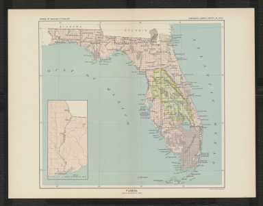
Geographical Description:
|
Shows Indian land cession according to treaty in 1823 and subsequent expansion approved by the President. Inset shows cession in Apalachicola River area.
|
|
Cartobibliographic notes:
|
Accompanies report on Florida in: Eighteenth annual report of the Bureau of American Ethnology. Part 2, Indian land cessions in the United States / by Charles C. Royce.
In margin above map: "Bureau of Ethnology. Eighteenth annual report. Pl. CXXiI."
This is a duplicate of accession number L2018.053.020
|
|
Subject Information:
|
Indians of North America
|
|
Subject Information:
|
Indian land transfers
|
|
Subject Information:
|
Florida
|
|
Related Item(s):
|
L2018.053.020
|
|
OCLC:
|
1110110542
|