Detail View: Touchton Map Library: City of Jacksonville Duval Co., 1887 + 1/2
|
Accession Number:
|
2016.059.019
|
|
Short Title:
|
City of Jacksonville Duval Co., 1887 + 1/2
|
|
Full Title:
|
City of Jacksonville Duval Co., 1887 + 1/2, Issued by the Board of Trade of Jacksonville, Fla., Copyrighted by J. Francis Le Baron, C. E., 1887
|
|
Year:
|
1887
|
|
Author:
|
J. Francis Le Baron (Civil Engineer and U.S. Deputy Surveyor)
|
|
Institution:
|
Board of Trade Jacksonville, Fla
|
|
Surveyor:
|
J. Francis Le Baron
|
|
Seller:
|
J. Francis Le Baron
|
|
Obj Height cm:
|
43
|
|
Object Width cm:
|
55.5
|
|
Scale:
|
yes
|
|
Multiple Sheets:
|
no
|
|
Neatline:
|
yes
|
|
Continent:
|
North America
|
|
Country:
|
United States
|
|
State:
|
Florida
|
|
City:
|
Jacksonville
|
|
Geographic Area:
|
Florida panhandle
|
|
Geographic Area:
|
St. John's River
|
|
County:
|
Duval
|
|
Language:
|
English
|
|
Type:
|
city map
|
|
Geographical Description:
|
City of Jacksonville, Fla
|
|
Cartobibliographic notes:
|
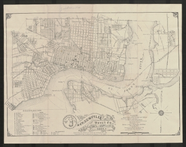
Map entitled "City of Jacksonville Duval Co., Fla. 1887 + 1/2." According to text printed along the bottom edge, it was issued by Jacksonville's Board of Trade and copyrighted by J. Francis Le Baron, C. E., 1887; additional text near the bottom right corner states that it was "Made from actual surveys and Official Records, and for sale by J. Francis Le Baron." A table of references in the bottom left corner provides a key to the location of miscellaneous significant buildings (e.g., Florida Yacht Club, Greenleaf's Museum, Murphy's Foundry, and the State Fair Grounds and Buildings), as well as depots, schools, banks, "Principal Hotels," and buildings belonging to the Fire Department. Neighborhoods are labeled, as well as streets.
|
|
Subject Information:
|
Duval County, Jacksonville, churches, sawmills
|