Detail View: Touchton Map Library: Head of Tampa Bay, Fla
|
Accession Number:
|
2009.001.030
|
|
Short Title:
|
Head of Tampa Bay, Fla
|
|
Full Title:
|
Head of Tampa Bay, Fla, from Coast Chart No. 77 H.S.C. & G.S.
|
|
Year:
|
1887
|
|
Engraver or Printer:
|
N. M. Black
|
|
Obj Height cm:
|
28.5
|
|
Object Width cm:
|
23
|
|
Scale:
|
yes
|
|
Multiple Sheets:
|
no
|
|
Neatline:
|
yes
|
|
Continent:
|
North America
|
|
Country:
|
United States
|
|
State:
|
Florida
|
|
Geographic Area:
|
Florida panhandle
|
|
County:
|
Hillsborough County
|
|
Language:
|
English
|
|
Type:
|
nautical chart
|
|
Geographical Description:
|
waters of Old Tampa Bay and Hillsborough Bay
|
|
Cartobibliographic notes:
|
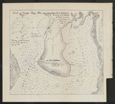
Upper right reads, "To accompany annual report for 1887. N.M. Black, Capt & Eng At the upper left corner, Plate 1 shows the velocity of tidal currents with respect to the age of the tide, and Plate 2 shows directions and velocity of tidal currents and direction of the channel. Location of prop dyke, dredge channel, and current obstructions are noted.
|
|
Subject Information:
|
Old Tampa Bay
|
|
Subject Information:
|
Hillsboro Bay
|
|
Subject Information:
|
nautical chart
|
|
Related Item(s):
|
L2018.053.193
|
|
Related Item(s):
|
L2018.018.012
|