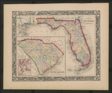
Detail View: Touchton Map Library: County Map of Florida and South Carolina
|
Accession Number:
|
1996.051.2555
|
|
Short Title:
|
County Map of Florida and South Carolina
|
|
Full Title:
|
County Map of Florida, County Map of South Carolina
|
|
Year:
|
1860
|
|
Engraver or Printer:
|
S. Augustus Mitchell, Jr.
|
|
Obj Height cm:
|
33
|
|
Object Width cm:
|
39.5
|
|
Scale:
|
yes
|
|
Multiple Sheets:
|
no
|
|
Neatline:
|
yes
|
|
Continent:
|
North America
|
|
Country:
|
United States
|
|
State:
|
Florida
|
|
State:
|
South Carolina
|
|
Decorative Cartouche:
|
Around the neatline is a 1.5 cm decorative border of flowers, foilage, and ribbons
|
|
Language:
|
English
|
|
Insets:
|
Charleston Harbor
|
|
Type:
|
county map
|
|
Geographical Description:
|
two states in the southeastern United States: Florida and South Carolina
|
|
Cartobibliographic notes:
|
South Carolina appears in a box at lower left of map where the Gulf of Mexico would otherwise appear. The different counties in the states are differentiated by both dashed lines and color.
|
|
Subject Information:
|
South Carolina
|
|
Subject Information:
|
Florida
|
|
Subject Information:
|
Charleston Harbor
|
|
Subject Information:
|
County map
|