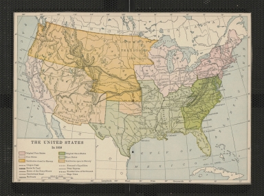
Detail View: Touchton Map Library: The United States in 1850
|
Accession Number:
|
2000.084.086
|
|
Short Title:
|
The United States in 1850
|
|
Full Title:
|
The United States in 1850
|
|
Obj Height cm:
|
28.5
|
|
Object Width cm:
|
23
|
|
Scale:
|
yes
|
|
Multiple Sheets:
|
no
|
|
Neatline:
|
no
|
|
Continent:
|
North America
|
|
Country:
|
United States
|
|
Geographic Area:
|
North America
|
|
Geographical Description:
|
United States
|
|
Cartobibliographic notes:
|
Printed map of the United States in 1850 color coding slave and free states and territories along with well known trails and railroads. The legend, located in the lower left corner of the map, provides a key depicting what each color on the map means along with the symbology used for various trails, roads, and railroads, and provides a scale of miles. Latitude and longitude markings border the map. Appears to have been cut from source along the neatline.
|