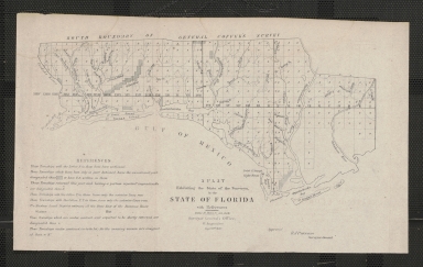
Detail View: Touchton Map Library: A Plat Exhibiting the State of the Surveys, in the State of Florida
|
Accession Number:
|
2017.035.017
|
|
Short Title:
|
A Plat Exhibiting the State of the Surveys, in the State of Florida
|
|
Year:
|
1850
|
|
Month & Day:
|
Sept. 30th
|
|
Author:
|
B.A. Putnam
|
|
Object Publisher:
|
Surveyor General's Office
|
|
Place of Publication:
|
St. Augustine
|
|
Pub Note:
|
Approved B.A. Putnam, Surveyor General
|
|
Obj Height cm:
|
19
|
|
Object Width cm:
|
32
|
|
Scale:
|
18 Miles to an Inch
|
|
Neatline:
|
No
|
|
Continent:
|
North America
|
|
Country:
|
United States
|
|
State:
|
Florida
|
|
City:
|
St. George's Island; Apalachicola
|
|
Geographic Area:
|
South Boundary of General Coffee's Survey; St. Joseph Bay; St. George's Island; Apalachicola Bay
|
|
Geographic Area:
|
Florida Panhandle; northern Gulf Coast; Gulf of Mexico
|
|
County:
|
Franklin
|
|
Color Type:
|
Uncolored
|
|
Language:
|
English
|
|
Cartobibliographic notes:
|
References: Those Townships with the Letter S in them have been sectioned; Those Townships which have been only in part Sectioned have the unsectioned part designated this [diagonal shading] or have P.S. written in them; Those Townships returned this year and having a portion reported impracticable are designated thus [S with asterisk above]; Those Townships with the letter T. in them have only the exterior lines run; Those Townships with the letters P.R. in them have only the exterior lines run; The Eastern Land District embraces all the State East of the Suwanee River; The Western Land District embraces all the State West of the Suwanee River; Those Townships which are under contract and expected to be shortly returned are designated thus [cross]; Those townships under contract (or to be let) fr the ensuing season are designated thus, &c.
|
|
Subject Information:
|
Boundaries,Land surveys, Land plots, Rivers, Townships, Land sectioning, Lighthouses, General Coffee, Waterways, Land use
|
|
Related Item(s):
|
L2018.098.015.001
|