Detail View: Touchton Map Library: Cram's New Indexed Sectional Map of the State of Florida, Showing Private and Government Grants, Prairie, Sawgrass Marsh, Swamp, and Hammock Lands. Compiled from official Records of the General Land Office and other Sources
|
Accession Number:
|
2016.014.026
|
|
Short Title:
|
Cram's New Indexed Sectional Map of the State of Florida, Showing Private and Government Grants, Prairie, Sawgrass Marsh, Swamp, and Hammock Lands. Compiled from official Records of the General Land Office and other Sources
|
|
Year:
|
1884
|
|
Object Publisher:
|
George F. Cram
|
|
Place of Publication:
|
Chicago, Illinois
|
|
Obj Height cm:
|
103.5
|
|
Object Width cm:
|
105
|
|
Scale:
|
yes
|
|
Neatline:
|
yes
|
|
Continent:
|
North America
|
|
Country:
|
United States
|
|
State:
|
Florida
|
|
Geographic Area:
|
Southeast United States
|
|
Language:
|
English
|
|
Type:
|
railroad map
|
|
Geographical Description:
|
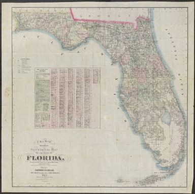
The map is colored by counties and shows the extent of the General Land Office Township Surveys in Florida.
The Index includes an Explanation, list of Railroads, etc., with the map itelf showing:
Post Offices
Telegraph Stations
Court Houses
Railways
All areas with a population over 100
Railroad Grant Limits
Government and Private Grants
Sawgrass, Marsh and Swamp lands
Prairie
Large Hammocks
This is without question one of the most detailed privately printed maps of Florida in the 19th Century and one of the largest.
|
|
Cartobibliographic notes:
|
Map appears to have water damage State of Florida has been divided into plats. Cities are marked as well as post offices. Post offices that provide money orders and have a telegraph station are also marked. Railway lines are indicated, not roads. In the lower left is an index to the map providing information on four topics: one, symbols and typeface are explained; two, railroad routes are named and the cities they service listed; three, an index to counties and their respective population is provided; and four, an index to towns and their respective populations is provided.
|
|
Subject Information:
|
Florida
|
|
Subject Information:
|
railroad
|
|
Subject Information:
|
population
|