Detail View: Touchton Map Library: Pensacola Bay Florida & Key West Island Florida
|
M Number:
|
M1049
|
|
Short Title:
|
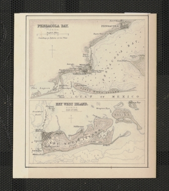
Pensacola Bay Florida & Key West Island Florida
|
|
Year:
|
1872
|
|
Date Range:
|
1864-1872
|
|
Author:
|
Archibald Fullarton
|
|
Engraver or Printer:
|
John Bartholomew, Jr.
|
|
Publisher:
|
A. Fullarton & Co.
|
|
Publisher Location:
|
London and Edinburgh
|
|
Pub Title:
|
The Royal Illustrated Atlas, Of Modern Geography With An Introductory Notice By Dr. N. Shaw, Secretary To The Royal Geographical Society &c. A. Fullarton And Co. London And Edinburgh. (title page only) W.B. Scott. W. Holl.
|
|
Pub Note:
|
Plate LX a (Plate 60 a), maps five and six. This sheet was cut from the lower right portion of the page/plate. Other maps on the overall plate (though not present on this particular sheet) include Washington; Beaufort Harbor, North Carolina; Mobile, Alabama; Charleston Harbor, South Carolina; Galveston Entrance, Texas; and Delta of the Mississippi and Environs of New Orleans.
|
|
Pub Type:
|
World Atlas
|
|
Continent:
|
North America
|
|
Country:
|
United States
|
|
State:
|
Florida
|
|
City:
|
Pensacola; Key West
|
|
Geographic Area:
|
Florida Panhandle; Florida Keys
|
|
County:
|
Escambia; Monroe
|
|
Cited References:
|
Rumsey Map Center has the entire atlas; see also Tooley for additional references
|