Detail View: Touchton Map Library: [Topographic maps of lands in Indian River County area, Florida]. Plate 3.
|
Accession Number:
|
L2018.111.002.001
|
|
M Number:
|
M1243(a)
|
|
Short Title:
|
[Topographic maps of lands in Indian River County area, Florida]. Plate 3.
|
|
Date Range:
|
1800s
|
|
Obj Height cm:
|
33
|
|
Object Width cm:
|
20
|
|
Scale:
|
no
|
|
Continent:
|
North America
|
|
Country:
|
United States
|
|
State:
|
Florida
|
|
Geographic Area:
|
Saint Johns River
|
|
Geographic Area:
|
Saint Sebastian River
|
|
Geographic Area:
|
Indian River
|
|
County:
|
Indian River County
|
|
Language:
|
English
|
|
Type:
|
Topographic map
|
|
Geographical Description:
|
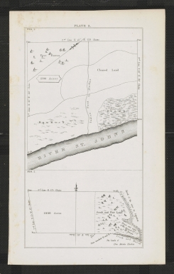
Part of a series of maps showing topography of areas around St. Johns River, Indian River, and St. Sebastian River in the Indian River County area. Plate 3 shows 2 maps. Figure 1 shows portion of St. Johns and land designated pine barren, hommock, and swamp. Figure 2 shows marsh of the St. Sebastian, scrub and pine land.
|
|
Cartobibliographic notes:
|
No title on maps. Collective title assigned by cataloger.
|
|
Subject Information:
|
Indian River County (Fla.)
|
|
Subject Information:
|
Saint Johns River (Fla.)
|
|
Subject Information:
|
Saint Sebastian River (Fla.)
|
|
Subject Information:
|
Indian River (Fla. : Lagoon)
|
|
OCLC:
|
1111802752
|