Detail View: Touchton Map Library: St. Andrew's Bay.
|
Accession Number:
|
L2018.111.012
|
|
M Number:
|
M912
|
|
Short Title:
|
St. Andrew's Bay.
|
|
Full Title:
|
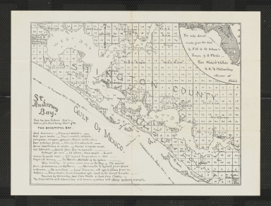
St. Andrew's Bay. The Beautiful Bay.
|
|
Year:
|
1889
|
|
Engraver or Printer:
|
August Gast Banknote & Lithographing Company
|
|
Object Publisher:
|
August Gast Banknote & Lithographing Company.
|
|
Place of Publication:
|
St. Louis or New York
|
|
Obj Height cm:
|
18
|
|
Object Width cm:
|
24
|
|
Scale:
|
no
|
|
Continent:
|
North America
|
|
Country:
|
United States
|
|
State:
|
Florida
|
|
City:
|
St. Andrews; Gold Town; Harrison; Craman, Parker (historic names on map); Panama City
|
|
Geographic Area:
|
St. Andrew Bay
|
|
County:
|
Washington; Calhoun; Bay
|
|
Language:
|
English
|
|
Verso:
|
Handwritten note dated 1/30/90.
|
|
Insets:
|
Inset shows map of Florida and Mobile, Alabama, with mileage listed from Mobile to St. Andrews Bay and St. Andrews Bay to Tampa. Includes text.
|
|
Direction/Orientation:
|
north at the top
|
|
Type:
|
Lithograph
|
|
Geographical Description:
|
Cadastral map showing townships, ranges, and lots for area in Washington and Calhoun Counties, Florida near St. Andrews Bay (also called St. Andrew Bay). The area is not part of Bay County, which was created from parts of Washington County and Calhoun County in 1913.
|
|
Cartobibliographic notes:
|
Includes promotional text on St. Andrews Bay area.
|
|
Subject Information:
|
Real property
|
|
Subject Information:
|
Saint Andrew Bay (Fla.)
|
|
Subject Information:
|
Washington County; Calhoun County; Bay County; Panama City
|
|
Related Item(s):
|
2019.012.001 (1887) and 2018.115.001 (1912) show the same geographic area.
|
|
OCLC:
|
1129591155
|