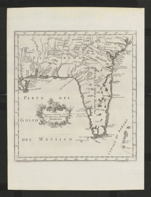
Detail View: Touchton Map Library: Carta rappresentante la Penisola della Florida.
|
Accession Number:
|
L2018.111.034
|
|
M Number:
|
M179
|
|
Short Title:
|
Carta rappresentante la Penisola della Florida.
|
|
Date Range:
|
1763?
|
|
Author:
|
Andrea Scacciati
|
|
Engraver or Printer:
|
Giusepped Pazzi
|
|
Obj Height cm:
|
23
|
|
Object Width cm:
|
22
|
|
Scale:
|
ca. 1:6,000,000
|
|
Continent:
|
North America
|
|
Country:
|
United States
|
|
State:
|
Florida
|
|
Geographic Area:
|
Southern States
|
|
Language:
|
Italian
|
|
Geographical Description:
|
Shows southeastern United States, west to Pearl River, Louisiana and Mississippi, and north to latitude 34 degrees.
|
|
Subject Information:
|
Florida
|
|
Subject Information:
|
Southern States
|
|
OCLC:
|
5400343
|