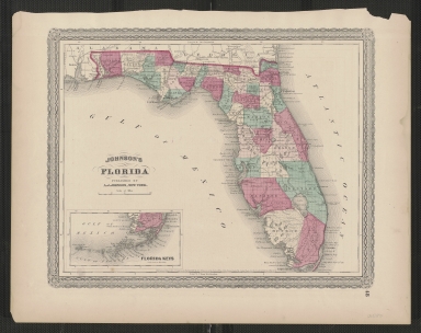
Detail View: Touchton Map Library: Johnson's Florida.
|
Accession Number:
|
L2019.068.064
|
|
M Number:
|
M507
|
|
Short Title:
|
Johnson's Florida.
|
|
Year:
|
1870
|
|
Author:
|
A.J. Johnson
|
|
Object Publisher:
|
A.J. Johnson
|
|
Place of Publication:
|
New York
|
|
Obj Height cm:
|
26
|
|
Object Width cm:
|
34
|
|
Scale:
|
ca. 1:2,600,000
|
|
Continent:
|
North America
|
|
Country:
|
United States
|
|
State:
|
Florida
|
|
Language:
|
English
|
|
Verso:
|
Geographical index, or ready reference.
|
|
Insets:
|
Florida Keys.
|
|
Geographical Description:
|
Shows counties, towns, canals, and railroads on a township grid.
|
|
Cartobibliographic notes:
|
"Entered according to Act of Congress, in the Year 1863 by A.J. Johnson, in the Clerks Office of the District Court of the United States, for the Southern District of New York."
Decorative border with rosette in each corner.
In lower right margin: 48.
Publication date of 1870 derived from information in "Ira Lourie's Johnson U.S. Map Project" web site.
|
|
Subject Information:
|
Florida
|
|
Subject Information:
|
Railroads
|
|
OCLC:
|
1127643263
|