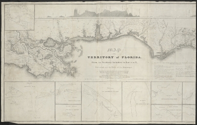
Detail View: Touchton Map Library: Map of the Territory of Florida.
|
Accession Number:
|
L2011.070.167.001
|
|
M Number:
|
M110a
|
|
Short Title:
|
Map of the Territory of Florida.
|
|
Full Title:
|
Map of the Territory of Florida. From its Northern boundary to Lat: 27, 50 N, Connected with the Delta of the Mississippi. Annexed to the report of the Board of Internal Improvement dated Feby. 19th 1829 relating to the Canal contemplated to connect the Atlantic with the Gulf of Mexico; and describing the Inland Navigation parallel to the Coast from the Mississippi to the Bay of Espiritu Santo; and from St. Mary's Harbour to St. Augustine.
|
|
Year:
|
1829
|
|
Month & Day:
|
February 19
|
|
Author:
|
William Henry (W. H.) Swift
|
|
Contributor(s):
|
Simon Bernard
|
|
Contributor(s):
|
William Tell Poussin
|
|
Institution:
|
Florida Board of Internal Improvements
|
|
Surveyor:
|
William Tell Poussin; James Kearney; Frederick Searle; Benjamin Huger; Abbott Hall Brisbane; Paul Hyacinte Perrault; Augustus Canfield; Smith; Walter Gwynn
|
|
Continent:
|
North America
|
|
Country:
|
United States
|
|
State:
|
Florida
|
|
Geographic Area:
|
Florida Territory
|
|
Language:
|
English
|
|
Insets:
|
Entrance to Mobile Bay Lt. Col. James Kearney
|
|
Insets:
|
Entrance to Pensacola Bay Lt. Col. James Kearney
|
|
Insets:
|
Eastern entrance to St. Rosa Sound Lts. Canfield & Smith
|
|
Insets:
|
Entrances to St. Andrew's Sounds Lt. Swift
|
|
Insets:
|
Entrance to St. Joseph's Bay Lt. Swift
|
|
Insets:
|
Entrance to Appalachicola Bay Lt. Swift
|
|
Insets:
|
Main entrance to St. George's Sound Lt. Swift
|
|
Direction/Orientation:
|
North at the top
|
|
Geographical Description:
|
Top portion shows Level of low water in Appalachicola Bay Gulf of Mexico & Level of low-water in the St. Marys R. & Level of low-water in the Gulf & Suwanee River at the Indian Cowpen
|