Detail View: Touchton Map Library: New Map of Florida, 1879
|
Accession Number:
|
L2018.058.088.001
|
|
M Number:
|
M444
|
|
Short Title:
|
New Map of Florida, 1879
|
|
Year:
|
1879
|
|
Author:
|
Rand, McNally & Co.
|
|
Object Publisher:
|
Florida Bureau of Immigration
|
|
Place of Publication:
|
Tallahassee
|
|
Obj Height cm:
|
48
|
|
Object Width cm:
|
31
|
|
Scale:
|
1:2,090,880
|
|
Continent:
|
North America
|
|
Country:
|
United States
|
|
State:
|
Florida
|
|
Language:
|
English
|
|
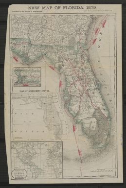
Insets:
|
Continuation of western Florida
|
|
Insets:
|
Plan of government survey
|
|
Insets:
|
Steamship lines from Europe via New York to Florida
|
|
Geographical Description:
|
Shows state of Florida, with map extending north to Savannah, Georgia and also the southeastern portion of Alabama.
|
|
Cartobibliographic notes:
|
Uses solid red lines to denote chartered railroads and dashed red lines to denote steamship lines. Originally issued folded. Cover panel has title: Florida as it is. Cover scanned separately.
|
|
Subject Information:
|
Florida.
|
|
Subject Information:
|
Railroads.
|
|
Subject Information:
|
Steamboat lines.
|
|
Related Item(s):
|
2001.097.007.002
|
|
OCLC:
|
925551315
|