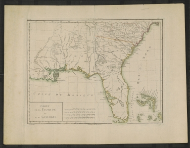
Detail View: Touchton Map Library: Carte de la Floride et de la Georgie.
|
Accession Number:
|
L2018.087.023
|
|
M Number:
|
M157
|
|
Short Title:
|
Carte de la Floride et de la Georgie.
|
|
Date Range:
|
1782?
|
|
Author:
|
P.F. Tardieu
|
|
Contributor(s):
|
P.J. Valet
|
|
Object Publisher:
|
Edme Mentelle
|
|
Place of Publication:
|
Paris
|
|
Obj Height cm:
|
32
|
|
Object Width cm:
|
42
|
|
Scale:
|
ca. 1:3,500,000
|
|
Continent:
|
North America
|
|
Country:
|
United States
|
|
Country:
|
Bahamas
|
|
Geographic Area:
|
Southern States
|
|
Language:
|
French
|
|
Geographical Description:
|
Shows cities, major roads, swamps, and areas of Indian habitation inland and along the coasts of Louisiana, Florida, Georgia, and South Carolina; the Bahama Islands.
|
|
Cartobibliographic notes:
|
Above map: No. 159, 136.
Published in: Atlas nouveau, 1782.
|
|
Subject Information:
|
Southern States
|
|
Subject Information:
|
Bahamas
|
|
Subject Information:
|
Indians of North America
|
|
Related Item(s):
|
L2018.087.024
|
|
OCLC:
|
752591160
|