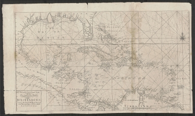
Detail View: Touchton Map Library: A new and correct large chart of the tradeing part of the West Indies.
|
Accession Number:
|
L2018.087.032
|
|
M Number:
|
M431
|
|
Short Title:
|
A new and correct large chart of the tradeing part of the West Indies.
|
|
Year:
|
1713
|
|
Object Publisher:
|
Richard & William Mount and Thomas Page
|
|
Place of Publication:
|
London
|
|
Obj Height cm:
|
47
|
|
Object Width cm:
|
82
|
|
Scale:
|
ca. 1:6,000,000
|
|
Continent:
|
North America
|
|
Country:
|
United States
|
|
Country:
|
Mexico
|
|
Geographic Area:
|
West Indies
|
|
Geographic Area:
|
Central America
|
|
Language:
|
English
|
|
Geographical Description:
|
Shows Gulf Coast and Caribbean Area.
|
|
Subject Information:
|
Gulf Coast (U.S.)
|
|
Subject Information:
|
West Indies
|
|
Subject Information:
|
Mexico
|
|
Subject Information:
|
Central America
|
|
OCLC:
|
1135463744
|