|
REFINE
Browse All : Images from 1852
1-27 of 27
Short Title
G. No. 3 Reconnaissance of the bar and channel of St. Marks on the western coast of Florida
Year
1852
Author
F. H. Gerdes
Short Title
G No. 3 Reconnaissance of the bar and channel of St. Marks on the western coast of Florida
Year
1852
Author
F. H. Gerdes
Short Title
Map of the Straits of Florida and Gulf of Mexico.
Year
1852
Author
U.S. Coast Survey
Short Title
Map of the Straits of Florida and Gulf of Mexico.
Year
1852
Author
U. S. Coast Survey
Short Title
North America. XIV, Florida.
Year
1852
Author
Henry Schenck Tanner
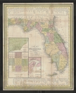
Short Title
Map of Florida
Year
1852
Author
Thomas, Cowperthwait & Co
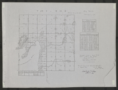
Short Title
T 29 S - R 19 E
Year
1852
Author
Charles F Hopkins
Short Title
Negative print of Sketch of Military Reserve of Fort Brooke in 1852
Year
1852
Short Title
Negative print of Sketch of Military Reserve of Fort Brooke in 1852
Year
1852
Short Title
Billy Bowlegs and Chiefs of the Seminole Indians
Year
1852
Short Title
Billy Bowlegs and Chiefs of the Seminole Indians
Year
1852
Short Title
Billy Bowlegs and Chiefs of the Seminole Indians
Year
1852
Short Title
Billy Bowlegs and Chiefs of the Seminole Indians
Year
1852
Short Title
(Sketch F No. 3) Preliminary Chart of Key West Harbor and Approaches
Year
1852
Author
A. D. Bache
Short Title
G No. 2 U. S. Coast Survey Reconnaissance of Channel No. IV Cedar-Keys Florida
Year
1852
Author
F. H. Gerdes
Short Title
G. No. 3 U. S. Coast Survey Reconnaissance of the Bar and Channel of St. Marks On the Western Coast of Florida
Year
1852
Author
F. H. Gerdes
Short Title
(Sketch F No. 3) Preliminary Chart of Key West Harbor and Approaches
Year
1852
Author
A. D. Bache
Short Title
Sketch F Showing the Progress of the Survey in Section VI With a General Reconnaissance of the Western Coast of Florida
Year
1852
Date Range
1848-52
Author
A. D. Bache
Short Title
Wind and Current Chart of the North Atlantic by M. F. Maury IMAGE FILE TOO LARGE, SEE FOLDER ON P DRIVE
Year
1852
Short Title
Wind and Current Chart of the North Atlantic by M. F. Maury IMAGE FILE TOO LARGE, SEE FOLDER ON P DRIVE
Year
1852
Short Title
Map of Florida Thomas, Cowperthwait & Co. notes routes of the Army during Seminole War
Year
1852
Author
Thomas, Cowperthwait & Co.
Short Title
Map of Florida Thomas, Cowperthwait & Co. notes routes of the Army during Seminole War
Year
1852
Author
Thomas, Cowperthwait & Co.
Short Title
Chart of the Bahama Islands and Banks and of the Strait of Florida & Adjacent Coasts; Drawn from the Late Surveys of Commanders Owen & Barnett of the Royal Navy, the Spanish & United States Coast Surveys & C.
Year
1852
1-27 of 27
|