|
REFINE
Browse All : Images from 1857
1-16 of 16
Short Title
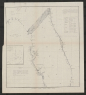
Sketch F Showing the Progress of the Survey in Section VI with a general reconnaissance of the Coast of Florida
Year
1857
Date Range
1848-57
Author
A. D. Bache
Short Title
Sketch F Showing the Progress of the Survey in Section VI with a general reconnaissance of the Coast of Florida
Year
1857
Date Range
1848-57
Author
A. D. Bache
Short Title
Map of the State of Florida, Showing the Progress of the Surveys.
Year
1857
Author
John Westcott
Short Title
Comparative chart of St. Johns River, Florida.
Year
1857
Author
F. Fairfax
Short Title
Chart of the Gulf of Florida, and the Bahama Islands…
Year
1857
Author
J. S. Hobbs
Short Title
Gulf of Mexico, West Indies & Spanish Main
Year
1845
Author
Blunt
Short Title
An 1857 publication by J. H. Colton titled "Comparative Size of Lakes and Islands" in the Eastern and Western Hemispheres.
Year
1857
Short Title
Preliminary Chart of Florida Reefs Showing the Approaches to Key West Harbor. A. D. Bache Survey of the COast of the United States 1857.
Year
1857
Short Title
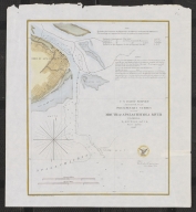
St. Mary's River and Fernandina Harbor Florida Survey of the Coast of the United States A. D. Bache
Year
1857
Author
Survey of the Coast of the United States
Short Title
States of South Carolina, Georgia, Alalbama, and Florida
Year
1857
Author
[Prof. H. D. Rogers, A. Keith Johnston]
Short Title
Map of the State of Florida, Showing the Progress of the Surveys Accompanying Annual Report of the Surveyor General for 1857
Year
1857
Short Title
U. S. Coast Survey Sketch G Showing the Progress of the Survey in Section No. VII from 1849 to 1857
Year
1857
Short Title
U. S. Coast Survey Sketch G Showing the Progress of the Survey in Section No. VII from 1849 to 1857
Year
1857
Short Title
U. S. Coast Survey Preliminary Survey of the Mouth of Apalachicola River Florida
Year
1857
Author
G. D. Wise
Short Title
Preliminary survey of the mouth of Apalachicola River, Florida.
Year
1857
Author
G.D. Wise
1-16 of 16
|