|
REFINE
Browse All : Images from 1860
1-22 of 22
Short Title
Map of the State of Florida Showing the Progress of the Surveys Accompanying Annual Report of the Surveyor General for 1860.
Year
1860
Author
Francis L. Dancy
Short Title
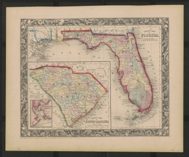
County Map of Florida
Year
1860
Author
S. Augustus Mitchell, Jr.
Short Title
County Map of Florida
Year
1860
Author
S. Augustus Mitchell, Jr.
Short Title
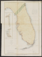
Sketch F Showing the Progress of the Survey in Section VI With a General Reconnaissance of the Coast of Florida
Year
1860
Date Range
1848-60
Author
A. D. Bache
Short Title
United States of North America (Eastern & Central) T. Ettling Weekly Dispatch Atlas 139
Year
1860
Author
T. Ettling
Short Title
Col. Taylor at the Battle of Okey Chobey J. R. Chapin & S. S. Swith
Year
1860
Author
J. R. Chapin & S. S. Swith
Short Title
Chart of the Gulf of Mexico and Windward Passages including the islands of Cuba, Haiti, Jamaica, Porto Rico, and the Bahamas. Compiled Principally from the Surveys made by order of the British, Spanish, and United States Governments
Year
1860
Short Title
Chart of the Gulf of Mexico and Windward Passages including the islands of Cuba, Haiti, Jamaica, Porto Rico, and the Bahamas. Compiled Principally from the Surveys made by order of the British, Spanish, and United States Governments
Year
1860
Short Title
Preliminary Chart of St. Augustine Harbor, Florida
Year
1860
Author
J. Hilguard
Short Title
County Map of Florida
Year
1860
Author
S. Augustus Mitchell, Jr.
Short Title
County Map of Florida
Year
1860
Author
S. Augustus Mitchell, Jr.
Short Title
County Map of Florida
Year
1860
Author
S. Augustus Mitchell, Jr.
Short Title
County Map of Florida
Year
1860
Author
S. Augustus Mitchell, Jr.
Short Title
County Map of Florida
Year
1860
Author
S. Augustus Mitchell, Jr.
Short Title
Coast of the United States, from Cape Fear to the Bahamas, with Plans of the Principal Harbors on an Enlarged Scale: Compiled From the Most Recent Surveys Made By Order of the United States Government, and Adjusted By the Latest Astronomical Observations
Year
1860
Author
Charles Copley
Short Title
Coast of the United States, from Cape Fear to the Bahamas, with Plans of the Principal Harbors on an Enlarged Scale: Compiled From the Most Recent Surveys Made By Order of the United States Government, and Adjusted By the Latest Astronomical Observations
Year
1860
Author
Charles Copley
Short Title
Preliminary Chart of Western Part of St. George's Sound Florida Survey of the Coast of the United States A. D. Bache
Year
1860
Author
Survey of the Coast of the United States
Short Title
Map of the State of Florida, Showing the Progress of the Surveys.
Year
1860
Author
Francis L. Dancy
Short Title
Georgia, Alabama and Florida
Year
1860
Author
J. H. Colton
Short Title
Georgia, Alabama and Florida
Year
1860
Author
J. H. Colton
1-22 of 22
|