|
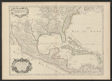
Short Title
Carte de la Florida occidentale et Louisiane ; la peninsule et golfe de la Floride ou canal de Bahama avec les isles de Bahama.
Year
1777
Author
Thomas Jefferys
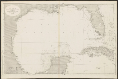
Short Title
Carta General del Seno Mejicano con los canales de Yucatan, Florida y Nuevo de Bahama.
Year
1869
Author
T. Bryant
Short Title
North America. East Coast, sheet VIII : Cumberland Sound to the Florida Channel.
Year
1847
Author
Captain E. Barnett.
Short Title
[America : the map of the colonies of the governments of England, Spain, and the United States.]
Year
1803
Author
Mahmoud Raif after William Faden
Short Title
A new map of the British colonies in North America, shewing the seat of the present war [bottom sheet only].
Year
1777
Author
John Andrews
Short Title
Carte des côtes du Golfe du Mexique.
Year
1800
Author
Depot General de la Marine
Short Title
Baie de Tampa ; Port de Sn. Augustin ; Embouchure de la rivière Sn. Juan ; Embouchure de la rivière Nassau.
Year
1831
Author
Dépôt des cartes et plans de la marine.
Short Title
Carte des Carolines Meridionale et Septenttrionale, la Georgie, la Floride, Orientale et Occididentale.
Year
1799
Author
J. B. Poirson
Short Title
Insulae Americanae in Oceano Septentrionali cum terris adiacentibus.
Date Range
1665?
Author
William Janszoon Blaeu
Short Title
Insulae Americanae in Oceano Septentrionali cum terris adiacentibus.
Date Range
1665?
Author
William Janszoon Blaeu
Short Title
Physical chart of the Atlantic Ocean.
Year
1856
Author
A. Keith Johnston
Short Title
Historical Map of Florida showing points of interest to visitors
Year
1934
Author
issued by the Florida State Department of Agriculture
Short Title
Historical Map of Florida showing points of interest to visitors
Year
1934
Author
issued by the Florida State Department of Agriculture
Short Title
Map of Florida
Date Range
1881-1883
Author
Rand McNally & Co.
Short Title
Historical Map of Florida Historical Data Concerning Florida
Year
1932
Author
issued by the Florida State Department of Agriculture
Short Title
Gadsden Point
Year
1947
Date Range
1944,1947
Author
Army Map Service
Short Title
Anna Maria
Year
1946
Date Range
1944,1946
Author
Army Map Service
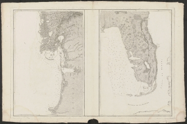
Short Title
Untitled proof state of Carte d'une Partie des Costes de la Floride... and Carte Reduite des Cotes et de L'Interieur de la Presqu'ile de la Floride
Year
1778
Date Range
ca. 1778 (check against final copy M#s)
Author
Antoine Sartine
Short Title
Map of Pinellas County Florida Roads
Year
1937
Author
E. N. Metzen
Short Title
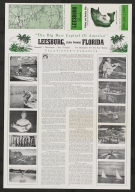
Fresh Water Fishing Guide of Leesburg, Florida and Vicinity
Date Range
c 1950s
Author
Finley C. Brooke
Short Title
Fresh Water Fishing Guide of Leesburg, Florida and Vicinity
Date Range
c 1950s
Author
Finley C. Brooke
Short Title
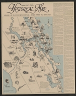
Historical Map Martin County, Florida
Year
1971
Author
[Ernest Lyons, Stuart Land Development, Inc.]
Short Title
El Portal Tampa's North Side Super Suburb
Year
1925
Author
Fernandez & Henderson Engineers
Short Title
El Portal Tampa's North Side Super Suburb
Year
1925
Author
Fernandez & Henderson Engineers
Short Title
Map of Lands Belonging to Florida Farms & Home, Inc., Located in Clay and Putnam Counties, Florida.
Year
1915
Author
Randall Wells
Short Title
Map of Lands Belonging to Florida Farms & Home, Inc., Located in Clay and Putnam Counties, Florida.
Year
1915
Author
Randall Wells
Short Title
Cote est de L'Amerique Septentrionale Floride. Riviere S te.Marie et Port de Fernandina
Year
1868
Date Range
1857
Author
Depot des Cartes et Plans de la Marine
Short Title
Tampa Bay
Year
1882
Date Range
1877-1879
Author
US Coast Survey
Short Title
Geologic and Topographic Map of Florida
Year
1909
Author
[United States Geological Survey, Florida State Geological Survey, E.H. Sellards]
Short Title
The Bell System of toll lines in the eastern portion of the United States and Canada.
Year
1909
Author
American Telephone and Telegraph Company
Short Title
Citrus Park, Florida, Hillsborough County.
Year
1947
Author
Army Map Service
Short Title
General topographical map sheet XI : [peninsular Florida]
Date Range
1891?
Author
United States War Dept.
Short Title
Sinclair road map : Florida.
Year
1937
Author
Rand McNally and Company
Short Title
Sinclair road map : Florida.
Year
1937
Author
Rand McNally and Company
Short Title
Carte du Mexique et de la Floride des Terres Angloises et des Isles Antilles.
Year
1703
Author
Guillaume de L'Isle
Short Title
Partie méridionale de la Louisiane, avec la Floride, la Caroline et la Virginie.
Year
1784
Author
Jean Baptiste Bourguignon d'Anville
Short Title
Perrine's new military map illustrating the seat of war.
Year
1862
Author
C. O. Perrine
Short Title
Perrine's new military map illustrating the seat of war.
Year
1862
Author
C. O. Perrine
Short Title
Sullivan and Mendenhall's guide map of Tampa and vicinity, Hillsborough County, Florida.
Year
1939
Author
Fred D. Mendenhall
Short Title
Map of Florida showing the main line and branches of The International Railroad and Steamship Company of Florida.
Year
1884
Author
G. W. & C. B. Colton & Co.
Short Title
Map of the state of Florida.
Date Range
ca. 1874
Author
Taintor Bros. & Merrill
Short Title
Map of central portion of St. Petersburg, Florida.
Date Range
1930s
Author
St. Petersburg Map & Blueprint Co.
Short Title
Map of central portion of St. Petersburg, Florida.
Date Range
1930s
Author
St. Petersburg Map & Blueprint Co.
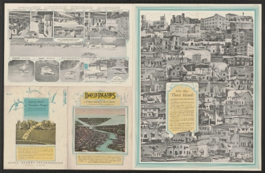
Short Title
Map of Davis Islands : Tampa in the Bay.
Year
1925
Author
G. F. Young
Short Title
Davis Islands : Tampa In the Bay.
Year
1927
Author
G.F. Young
Short Title
Davis Islands : Tampa In the Bay.
Year
1927
Author
G.F. Young
|


![[America : the map of the colonies of the governments of England, Spain, and the United States.]](https://luna.tampabayhistorycenter.org/MediaManager/srvr?mediafile=/Size2/TBHC~3~3/24/M1575.jpg)

![A new map of the British colonies in North America, shewing the seat of the present war [bottom sheet only].](https://luna.tampabayhistorycenter.org/MediaManager/srvr?mediafile=/Size2/TBHC~3~3/24/M1576.jpg)


![General topographical map sheet XI : [peninsular Florida]](https://luna.tampabayhistorycenter.org/MediaManager/srvr?mediafile=/Size2/TBHC~3~3/24/M129.jpg)