WHAT
-
"...a letter which set fo
…
(1)
-
"Every Man Can Own A Farm
…
(2)
-
admittance to Union
(1)
-
Advertisement
(5)
-
Advertisements
(1)
-
Aerial view
(3)
-
Aeronautical charts
(1)
-
Africa
(1)
-
African Americans
(1)
-
Agriculture
(21)
-
Air Force Eastern Test Ra
…
(2)
-
Air travel
(5)
-
Airports
(1)
-
Alabama
(7)
-
Alachua County (Fla.)
(5)
-
altlas
(1)
-
Amelia Island (Fla.)
(1)
-
Apalachicola (Fla.)
(3)
-
Apalachicola River (Fla.)
(1)
-
Apartments
(2)
-
Army, Seminole War, Troop
…
(1)
-
Arrow Head Hotel
(1)
-
Atlantic & Gulf Coast Can
…
(1)
-
Atlantic Coast (Fla.)
(4)
-
Atlantic Coast (Ga.)
(1)
-
Atlantic Coast (South Atl
…
(2)
-
Atlantic Coast (U.S.)
(8)
-
Atlantic Coast Line Railr
…
(2)
-
Atlantic Ocean
(2)
-
Atlantic States
(2)
-
Atlas
(3)
-
atlas
(1)
-
Atlas Map
(1)
-
Atlas map
(1)
-
Automobile driving
(2)
-
Automobile travel
(14)
-
Automobile travel.
(2)
-
Avon Park (Fla.)
(1)
-
Bahamas
(16)
-
Baker County (Fla.)
(1)
-
Ballistic missiles
(2)
-
Banana River (Fla.)
(1)
-
Bathymetric map
(1)
-
Battlefields
(4)
-
Battlegrounds
(1)
-
Beach Park (Tampa, Fla.)
(1)
-
Beaches
(2)
-
Beaches, Tourist attracti
…
(1)
-
Beacons
(2)
-
Bight redfish
(1)
-
Bird Key, FL
(2)
-
Bird refuges
(1)
-
Bird's-eye view
(1)
-
blue print, plat map
(1)
-
blueprint of Tampa
(2)
-
blueprint, plat map
(16)
-
Boats and boating
(1)
-
Boca Raton (Fla.)
(3)
-
Bok Tower (Lake Wales, Fl
…
(1)
-
Border States (U.S. Civil
…
(2)
-
Boundaries,Land surveys,
…
(1)
-
Bowman Heights
(1)
-
Bradenton (Fla.)
(2)
-
Bradford County (Fla.)
(1)
-
Brandon (Fla.)
(2)
-
Brevard County (Fla.)
(1)
-
Bridges
(1)
-
Bridges.
(1)
-
British Colonies; British
…
(1)
-
British Colonies; Colonia
…
(1)
-
Broward County (Fla.)
(2)
-
Buildings
(2)
-
Bulkheads
(3)
-
Bus lines
(4)
-
Bus travel
(1)
-
Cadastral map
(22)
-
Caloosahatchee River (Fla
…
(1)
-
Camp Cuba Libre (Fla.)
(1)
-
Canada
(2)
-
Canals
(6)
-
Canaveral, Cape (Fla.)
(1)
-
Caribbean Area
(10)
-
Caribbean Area.
(1)
-
Casey Key (Fla.)
(2)
-
Castillo de San Marcos (S
…
(1)
-
Cedar Keys
(1)
-
Cedar Keys (Fla. : Island
…
(1)
-
Central America
(4)
-
Charleston Harbor
(1)
-
Charlotte County (Fla.)
(3)
-
Charlotte Harbor (Fla. :
…
(1)
-
Citrus County (Fla.)
(1)
-
Citrus fruit industry
(1)
-
Citrus fruit industry.
(1)
-
city map
(1)
-
City of Tampa
(14)
-
City squares, Land lots,
…
(1)
-
Civil War, 1861-1865
(1)
-
Civil War, 1861-1865.
(1)
-
Claims
(1)
-
Clearwater (Fla.)
(4)
-
Clyde Steamship Company.
(1)
-
Collier County (Fla.)
(2)
-
Columbia County (Fla.)
(2)
-
Columbus, Christopher.
(1)
-
commemorative poster
(2)
-
Conference materials
(3)
-
Contests
(2)
-
Convention facilities
(1)
-
Coral Gables (Fla.)
(2)
-
Counties, Topography, Lan
…
(2)
-
County map
(1)
-
county map
(1)
-
Cross-stitch
(2)
-
Cuba
(30)
-
Cuba.
(1)
-
Cumberland Island (Ga.)
(1)
-
Cumberland Sound (Ga. and
…
(2)
-
Dade Battlefield Historic
…
(2)
-
Dade City (Fla.)
(2)
-
Dade Massacre, 1835
(2)
-
Dade Massacre, Fla., 1835
(3)
-
Davis Islands (Tampa, Fla
…
(3)
-
Daytona Beach (Fla.)
(5)
-
Daytona Beach Shores (Fla
…
(1)
-
De Land
(1)
-
De Land (Fla.)
(3)
-
De Soto County (Fla.)
(9)
-
Deerfield Beach (Fla.)
(2)
-
Delray Beach (Fla.)
(2)
-
Dixie Highway
(2)
-
Downtown River Arts Neigh
…
(1)
-
downtown Tampa
(2)
-
Dry Tortugas (Fla.)
(2)
-
Duval County (Fla.)
(4)
-
Duval County, Jacksonvill
…
(1)
-
East (U.S.)
(3)
-
East Tampa
(1)
-
Economic development
(1)
-
Egmont Key, FL
(2)
-
Electric lines
(4)
-
encyclopedia
(1)
-
Escambia County (Fla.)
(1)
-
Estates, Parks, Golf cour
…
(1)
-
Europe
(1)
-
Everglades (Fla.)
(1)
-
Everglades National Park
…
(1)
-
Explorers.
(1)
-
Federal Highway Program (
…
(1)
-
Fernandina (Fla.)
(1)
-
Fishing
(2)
-
Fishing Map
(12)
-
Florida
(527)
-
Florida Counties
(1)
-
Florida counties
(1)
-
Florida East Coast Railwa
…
(6)
-
Florida East Coast Railwa
…
(1)
-
Florida East Coast Steams
…
(1)
-
Florida Keys
(2)
-
Florida Keys (Fla.)
(9)
-
Florida roads 1884
(1)
-
Florida State Bankers Ass
…
(2)
-
Florida State Fair
(1)
-
Florida, Straits of.
(2)
-
Florida.
(45)
-
Florida; Gulf Coast (U.S.
…
(4)
-
Folded Brochure
(3)
-
Folded Brochure; Pleasure
…
(2)
-
Foldout Map
(1)
-
Football
(1)
-
Fort Brooke
(1)
-
Fort Lauderdale (Fla.)
(1)
-
Fortification
(2)
-
forts
(1)
-
Franklin County (Fla.)
(3)
-
French exploration; Spani
…
(1)
-
French Florida; French Lo
…
(1)
-
Frontier and pioneer life
(1)
-
Gadsden County (Fla.)
(1)
-
Game reserves
(1)
-
Gandy Bridge (Hillsboroug
…
(8)
-
Gandy Bridge(Hillsborough
…
(2)
-
Gardens
(1)
-
Geologic and Topographic
…
(1)
-
Geological map
(12)
-
Geology
(2)
-
Geology, Stratigraphic
(1)
-
Georgia
(15)
-
Georgia Colony; Spanish F
…
(1)
-
Georgia.
(2)
-
German maps of America
(1)
-
Glass bottom boats
(1)
-
Green Cove Springs (Fla.)
(1)
-
Guidebooks
(2)
-
Gulf Coast (Fla.)
(15)
-
Gulf Coast (La.)
(1)
-
Gulf Coast (Mexico)
(9)
-
Gulf Coast (U.S.)
(19)
-
Gulf States
(6)
-
Gulf Stream
(1)
-
Gulfport (Fla.)
(3)
-
Haines City (Fla.)
(1)
-
Halifax River (Fla.)
(1)
-
Harbor Oaks (Clearwater,
…
(1)
-
Harbors
(8)
-
Havana (Cuba).
(1)
-
Health resorts
(2)
-
Heliotype
(1)
-
Hernando County (Fla.)
(3)
-
Highland Park (Fla.)
(1)
-
Highlands County (Fla.)
(2)
-
Highways, Roads, Railroad
…
(1)
-
Hillsboro Bay
(1)
-
Hillsborough Bay (Fla.)
(2)
-
Hillsborough County (Fla
…
(41)
-
Hillsborough River (Polk
…
(1)
-
Hillsborough River State
…
(2)
-
Historic buildings, Histo
…
(1)
-
Historic Map
(1)
-
Historic Markers 1. Rough
…
(1)
-
historical events in Tamp
…
(1)
-
Historical geography
(5)
-
Historical geography.
(2)
-
Historical Map
(5)
-
Historical notes, Florida
…
(1)
-
History.
(1)
-
Hollywood (Fla.)
(2)
-
Homestead (Fla.)
(1)
-
Horticulture
(1)
-
Hotel Highland Lakes.
(1)
-
Hotel Seminole (Winter Pa
…
(1)
-
Hotels
(16)
-
Housing development
(1)
-
Hudson (Fla.)
(1)
-
Hudson Creek (Fla.)
(1)
-
Hyde Park
(2)
-
illustrated
(2)
-
Indian land transfers
(1)
-
Indian River (Fla. : Lago
…
(9)
-
Indian River County (Fla.
…
(4)
-
Indian Rocks Beach (Fla.)
(2)
-
Indians of North America
(18)
-
Industrial promotion
(1)
-
Industry
(1)
-
Inland water transportati
…
(1)
-
International Railroad an
…
(1)
-
International relations
(1)
-
Intracoastal waterways
(1)
-
Jackson County (Fla.)
(1)
-
Jacksonville (Fla.)
(5)
-
Jamaica
(2)
-
Jefferson County (Fla.)
(1)
-
Jigsaw puzzle
(2)
-
Jigsaw puzzles
(2)
-
Jonathan Dickinson, a Qua
…
(2)
-
Jupiter Island (Fla.)
(1)
-
Kenilworth Lodge.
(1)
-
Kennedy Space Center, Spa
…
(2)
-
Kentucky
(2)
-
Key West (Fla.)
(9)
-
Kissimmee River (Fla.)
(1)
-
Lafayette County (Fla.)
(2)
-
Lake City (Fla.)
(1)
-
Lake County
(1)
-
Lake Wales (Fla.)
(2)
-
Lakeland (Fla.)
(11)
-
Lakes
(1)
-
Land grants
(1)
-
land management
(1)
-
Land purchases, Boundarie
…
(1)
-
Land purchases, Townships
…
(1)
-
Land tenure
(1)
-
Largo (Fla.)
(1)
-
Lee County (Fla.)
(1)
-
Legal instruments
(2)
-
Lemon Bay (Fla.)
(1)
-
Leon County (Fla.)
(1)
-
Leroy (Fla.)
(9)
-
Levy County (Fla.)
(2)
-
Lighthouses
(2)
-
Lithograph
(2)
-
Local attractions, Beache
…
(1)
-
Lodging-houses
(1)
-
Louisiana
(4)
-
Lumber trade
(1)
-
Lynn Haven
(2)
-
Maine.
(2)
-
Manatee County (Fla.)
(12)
-
Manatee River (Fla.)
(2)
-
Mangroves, Topography, Na
…
(1)
-
Manuscript
(2)
-
Manuscript (facsimile)
(1)
-
Manuscript map
(1)
-
Marion County (Fla.)
(6)
-
Market surveys
(1)
-
Martin County (Fla.)
(1)
-
Maza Arredondo, Fernando
…
(1)
-
Mexico
(4)
-
Mexico, Gulf of
(8)
-
Mexico, Gulf of.
(5)
-
Miami (Fla.)
(26)
-
Miami Beach (Fla.)
(25)
-
Miami Metropolitan Area (
…
(4)
-
Miami-Dade County (Fla.)
(20)
-
Middle Atlantic States
(3)
-
Military campaigns.
(1)
-
Military camps.
(1)
-
military fort
(1)
-
Military map, Military ba
…
(1)
-
Mississippi
(2)
-
Mississippi River
(1)
-
Mobile (Ala.)
(7)
-
Monroe County (Fla.)
(1)
-
Mosquito Lagoon (Fla.)
(1)
-
Motels
(1)
-
Mullet Key, FL
(2)
-
Napkin; Souvenir Map
(1)
-
Nassau (Bahamas)
(3)
-
Nassau County (Fla.)
(4)
-
Nassau River (Fla.)
(2)
-
National Airlines
(1)
-
Nautical chart
(26)
-
nautical chart
(3)
-
Nautical charts
(2)
-
Nautical map
(2)
-
nautical map
(1)
-
Naval reservations, Stree
…
(1)
-
Navigation
(2)
-
Navigation Chart
(1)
-
Navigation chart
(1)
-
North America
(9)
-
North America.
(1)
-
North Carolina
(5)
-
Ocala (Fla.)
(1)
-
Ocala House (Ocala, Fla.)
(1)
-
Ocean currents
(2)
-
Ocean liner passengers
(2)
-
Ocean temperature
(1)
-
Old Seminole Heights
(4)
-
Old Spanish Trail
(2)
-
Old Tampa Bay
(1)
-
Old Tampa West
(1)
-
Old West Tampa
(1)
-
Orange County
(1)
-
Orange County (Fla.)
(4)
-
Orlando (Fla.)
(5)
-
Ormond Beach (Fla.)
(2)
-
Ormond Hotel (Ormond Beac
…
(1)
-
Osceola County
(1)
-
Palatka (Fla.)
(1)
-
Palm Beach County (Fla.)
(2)
-
Palm Key, FL
(2)
-
Panama Canal (Panama)
(1)
-
Parades
(1)
-
Parks
(1)
-
Pasco County (Fla.)
(1)
-
Patrick Air Force Base (F
…
(2)
-
Peace River Valley (Fla.)
(1)
-
Pennants
(1)
-
Pennsylvania (Ship)
(2)
-
Pensacola (Fla.)
(15)
-
Pensacola Bay (Fla.)
(10)
-
Perdido Bay (Fla. and Ala
…
(2)
-
Phosphate fields, Natural
…
(1)
-
Phytogeography
(1)
-
Pictorial map
(35)
-
Pictorial maps
(1)
-
Pine barrens
(1)
-
Pinellas County (Fla.)
(26)
-
Pirates
(2)
-
Place mats
(1)
-
Planned communities
(1)
-
Plant City (Fla.)
(1)
-
Plant System
(2)
-
Plat Map
(2)
-
plat map
(2)
-
Polk County
(1)
-
Polk County (Fla.)
(5)
-
Polk Hotel (Haines City,
…
(1)
-
Ponce de Leon Inlet (Fla.
…
(1)
-
Ponds
(1)
-
population
(1)
-
Population forecasting
(1)
-
Port Tampa (Fla.)
(6)
-
Potholders
(1)
-
Prairies
(1)
-
property map
(1)
-
Public land sales
(1)
-
Public lands
(1)
-
Punta Gorda Isles (Punta
…
(1)
-
Quebec Act of 1774, Terri
…
(1)
-
Railroad
(2)
-
railroad
(1)
-
Railroad land grants
(1)
-
railroad lines
(1)
-
Railroad Map
(1)
-
railroad map
(1)
-
Railroad travel
(12)
-
Railroad travel.
(1)
-
Railroads
(240)
-
Railroads, Construction,
…
(1)
-
Railroads, Railways, Tran
…
(1)
-
Railroads.
(32)
-
Railways, Transportation,
…
(1)
-
Rambler's Guide to Florid
…
(2)
-
Ravine State Gardens (Pal
…
(1)
-
Real estate development
(11)
-
Real estate development.
(1)
-
Real property
(57)
-
Real property auctions
(4)
-
Real property.
(27)
-
Reclamation of land
(1)
-
Reconnaissance of Tampa B
…
(2)
-
Recreation
(4)
-
Redington Beach (Fla.)
(2)
-
Resorts
(2)
-
Restaurants
(1)
-
Richard Hackley's Spanish
…
(1)
-
Ridgewood Park
(2)
-
Rivergrove
(2)
-
Rivers
(3)
-
Riverside Heights
(2)
-
Road map
(63)
-
road map
(2)
-
Road map.
(2)
-
Road maps
(1)
-
Road maps.
(2)
-
Roads
(108)
-
Roads.
(12)
-
Rowlett Park
(1)
-
Sable, Cape (Fla.)
(1)
-
Safety Harbor (Fla.)
(2)
-
sailing directions
(1)
-
Saint Andrew Bay (Fla.)
(1)
-
Saint Andrews Bay
(2)
-
Saint Augustine (Fla.)
(5)
-
Saint John River (Fla.)
(1)
-
Saint John River Valley (
…
(1)
-
Saint Johns County (Fla.)
(2)
-
Saint Johns River (Fla.)
(13)
-
Saint Marks River (Jeffer
…
(2)
-
Saint Mary's River (Ga. a
…
(1)
-
Saint Marys River (Ga. an
…
(3)
-
Saint Marys River (Georgi
…
(1)
-
Saint Petersburg (Fla.)
(11)
-
Saint Petersburg Beach (F
…
(2)
-
Saint Petersburg, Florida
(1)
-
Saint Sebastian River (Fl
…
(4)
-
Saint Vincent Island (Fla
…
(1)
-
Santa Rosa Island (Fla.)
(3)
-
Sarasota (Fla.)
(7)
-
Sarasota Bay (Fla.)
(1)
-
Sarasota Bay Region (Fla.
…
(1)
-
Sarasota County (Fla.)
(4)
-
sea chart
(1)
-
Sea-walls
(1)
-
Seabreeze (Fla.)
(2)
-
Seaplane bases
(1)
-
Sebring (Fla.)
(4)
-
Second Seminole War; Flor
…
(1)
-
Section map
(1)
-
Section map.
(1)
-
Seminole County (Fla.)
(2)
-
Seminole Heights
(2)
-
Seminole Indians are refe
…
(1)
-
Seminole Nation
(2)
-
Seminole War, 2nd, 1835-1
…
(4)
-
Seminole War, 2nd,1835-18
…
(1)
-
Shipment of goods
(2)
-
Shipping
(1)
-
Shipwrecks
(2)
-
Short Canal (Fla.)
(1)
-
Silver Springs (Fla.)
(5)
-
Soil profiles
(8)
-
Soil surveys
(10)
-
Soils
(11)
-
Soto, Hernando de, approx
…
(1)
-
South America
(4)
-
South Atlantic States
(15)
-
South Carolina
(9)
-
South Seminole Heights
(2)
-
Southeastern States
(1)
-
Southern States
(1)
-
Southern States
(32)
-
Southern states
(2)
-
Souveinr Map
(1)
-
Souvenir Map
(2)
-
Souvenir map
(2)
-
Spanish-American War, 189
…
(1)
-
Spanish-American War, 189
…
(1)
-
Sponge fisheries
(1)
-
Sports
(2)
-
St. Petersburg (Fla.)
(7)
-
St.Augustine during the U
…
(1)
-
Steamboat lines
(34)
-
Steamboat lines.
(6)
-
Steamship lines
(1)
-
steamship lines
(1)
-
Stieler's Hand Atlas
(1)
-
Street Map
(2)
-
Street view, Streets, Loc
…
(2)
-
Street-railroads
(2)
-
Streets
(5)
-
Streets.
(2)
-
Sumter County (Fla.)
(5)
-
Sunshine State Parkway
(2)
-
Super Bowl (18th : 1984 :
…
(1)
-
Superior, Lake
(1)
-
Surveying
(1)
-
Suwannee County (Fla.)
(1)
-
swamp land
(1)
-
Swamps
(2)
-
Tamp[a (Fla.)
(1)
-
Tampa
(3)
-
Tampa (Fla.)
(98)
-
Tampa Bay
(2)
-
Tampa Bay (Fla.)
(4)
-
Tampa Bay Hotel (Tampa, F
…
(5)
-
Tampa Bay Hotel.
(1)
-
Tampa Bay Region (Fla.)
(10)
-
Tampa Heights
(1)
-
Tampa International Airpo
…
(2)
-
Tangerine (Fla.)
(2)
-
Tarpon Springs (Fla.)
(1)
-
Telephone lines
(1)
-
Temple Crest
(2)
-
Temple Terrace (Fla.)
(8)
-
Tennessee
(2)
-
Territories, Land charter
…
(1)
-
The Marina Club of Tampa
(2)
-
This item was created dur
…
(2)
-
This item was created dur
…
(1)
-
This item was created dur
…
(4)
-
This items was created du
…
(2)
-
This map is among the ear
…
(1)
-
Timetables
(3)
-
Titusville (Fla.)
(1)
-
Toll roads
(2)
-
Topographic map
(14)
-
Topographical map
(1)
-
Topography, Roads, Canals
…
(1)
-
Topography, Shipwrecks, W
…
(1)
-
Tourist attractions, Loca
…
(2)
-
Tourist information cente
…
(2)
-
Tourist map
(2)
-
Tours
(1)
-
Towels
(1)
-
Townships, Land use, Swam
…
(1)
-
Traffic regulations.
(1)
-
Trails
(2)
-
trails
(1)
-
Treasure Island (Fla.)
(3)
-
Treasure troves
(4)
-
Trees
(1)
-
Trigonometric Survey
(1)
-
United Spanish War Vetera
…
(1)
-
United States
(9)
-
United States Highway 1
(2)
-
United States, East Coast
(1)
-
United States. Army. Corp
…
(1)
-
Vegetation boundaries
(1)
-
Volusia County (Fla.)
(3)
-
Voyages and travels.
(1)
-
Washington County; Calhou
…
(3)
-
Wauchula (Fla.)
(1)
-
Wellswood Estates
(2)
-
West (U.S.)
(1)
-
West Indies
(16)
-
West Indies.
(1)
-
West Palm Beach (Fla.)
(2)
-
West River
(2)
-
West Riverside Heights
(2)
-
Western Hemisphere
(1)
-
Wheel charts.
(3)
-
Winter Haven (Fla.)
(5)
-
Winter Park
(1)
-
Winter Park (Fla.)
(1)
-
World maps
(1)
-
world's fair
(1)
-
Ybor City (Tampa, Fla.)
(2)
-
Ye Mystic Krewe of Gaspar
…
(1)
-
yellow fever
(1)
-
Zephyrhills (Fla.)
(3)
Less
|
Browse All
:
Images of North America
Short Title
A New and Accurate Map of East and West Florida
Short Title
A New and Accurate Map of East and West Florida, Drawn from the best Authorities
Short Title
Florida, et regiones vicinae
Short Title
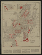
Diagram: of Tampa Land District
Short Title
A New Map of Georgia, with Part of Carolina, Florida and Louisiana
Short Title
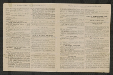
$100,000 worth of valuable real estate to be given absolutely free!
Author
Co-Operative Land and Improvement Company.
Short Title
$100,000 worth of valuable real estate to be given absolutely free!
Author
Co-Operative Land and Improvement Company.
Short Title
Map of Florida according to the latest authorities.
Short Title
Untitled manuscript map of Tampa Bay with Fort Brooke
Short Title
Untitled manuscript map of Tampa Bay with Fort Brooke
Short Title
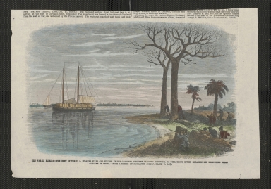
The War in Florida
Short Title
Insulae Americanae in Oceano Septentrionali ac Regiones Adiacentes, a C. de May usque ad Lineam Aequinoctialem
Short Title
Pas kaart van de boght van Florida : met de canaal tusschen Florida en Cuba.
Author
Claes Janszoon Vooght
Author
Boazio, Giovanni Battista
Short Title
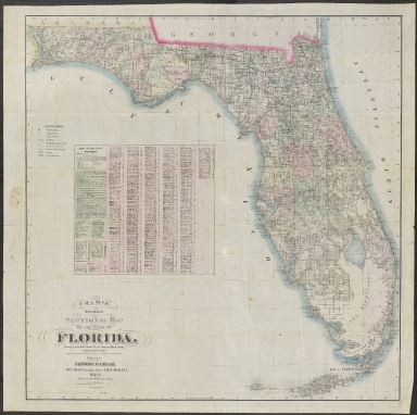
Cram's Map of Florida
Short Title
Cram's Map of Florida
Short Title
Cram's Standard County Colored Map of Florida
Short Title
Cram's Standard County Colored Map of Florida
Short Title
A map of the southern section of the United States including the Floridas & Bahama islands shewing the seat of war, in that department.
Short Title
A Map of Part of West Florida, from Pensacola to the Mouth of the Iberville River, with a View to Shew the Proper Spot for a Settlement on the Mississipi
Short Title
No. 1 A Map of Part of Alabama & Florida. Shewing the route of the proposed Columbus & Pensacola Rail Road.
Short Title
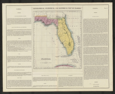
Geographical, Statistical, and Historical Map of Florida
Short Title
Geographisch-statistische und historische Charte von Florida
Short Title
Geographical, Statistical, and Historical Map of Florida
Short Title
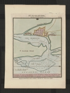
St. Augustine
Short Title
Official Map of the City of Tampa Florida and Vicinity
Short Title
Official Map of the City of Tampa Florida and Vicinity
Short Title
Official Map of the City of Tampa Florida and Vicinity
Short Title
Official Map of the City of Tampa Florida and Vicinity
Short Title
Tampa, Hillsborough County, Florida
Author
Greater Tampa Chamber of Commerce
Short Title
Hawthorne Heights The Lake Bound Center of Florida
Short Title
Hawthorne Heights The Lake Bound Center of Florida
Short Title
Partie méridionale de la rivière de Missisipi, et ses environs, dans l'Amérique Septentrionale.
Short Title
Detail Map of Tampa, Clearwater, St. Petersburg & Vicinity
Short Title
Sectional map of our New Lithia Lands, suburban to Tampa in Hillsboro County, Florida.
Author
North Tampa Land Co.
Short Title
Sectional map of our New Lithia Lands, suburban to Tampa in Hillsboro County, Florida.
Author
North Tampa Land Co.
Short Title
Map of North America Showing Direct Passenger Transportation Lines between the United States, Mexico, The West Indies, Central and South America, also Illustrating the Geographical position of Florida and Location of the Railroad, Steamboat and Steamship Lines of the Plant System for Commerce with other States and the Countries South and East of the Gulf of Mexico
Short Title
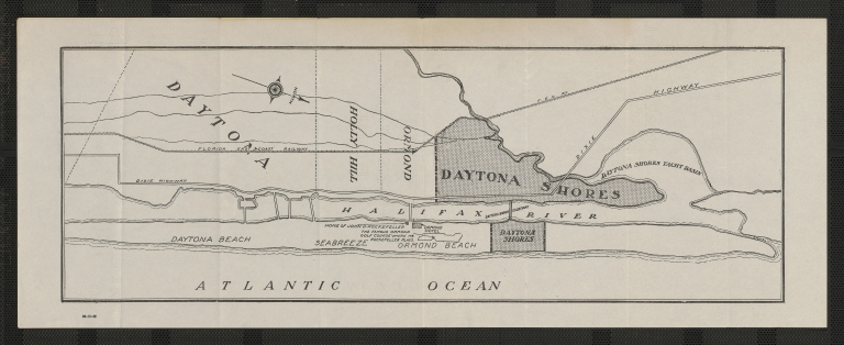
Daytona Shores
Short Title
Cram's New Indexed Sectional Map of the State of Florida, Showing Private and Government Grants, Prairie, Sawgrass Marsh, Swamp, and Hammock Lands. Compiled from official Records of the General Land Office and other Sources
Short Title
Revised map of Berkeley.
Short Title
Table of land measurements.
Short Title
Table of land measurements.
Short Title
Port et Barre D'Amelia de la Floride Orientale
Author
Georges Louis Le Rouge
Short Title
Carte réduite des costes de la Louisiane et de la Floride.
Author
Jacques Nicolas Bellin
Short Title
Location of the Clark Syndicate Lands & Enterprises
Short Title
Location of the Clark Syndicate Lands & Enterprises
Short Title
Location of the Clark Syndicate Farming Lands and Enterprises
Short Title
Location of the Clark Syndicate Farming Lands and Enterprises
|