|
Short Title
A New and Accurate Map of East and West Florida
Year
1765
Short Title
A New and Accurate Map of East and West Florida, Drawn from the best Authorities
Year
1765
Author
Thomas Kitchin
Short Title
Florida, et regiones vicinae
Date Range
1630-1640
Author
Joannes de Laet
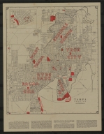
Short Title
Diagram: of Tampa Land District
Author
A Hoen & Co.
Short Title
A New Map of Georgia, with Part of Carolina, Florida and Louisiana
Year
1748
Author
Emanuel Bowen
Short Title
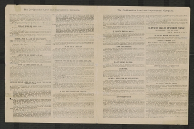
$100,000 worth of valuable real estate to be given absolutely free!
Date Range
1889?
Author
Co-Operative Land and Improvement Company.
Short Title
$100,000 worth of valuable real estate to be given absolutely free!
Date Range
1889?
Author
Co-Operative Land and Improvement Company.
Short Title
Map of Florida according to the latest authorities.
Year
1827
Short Title
Untitled manuscript map of Tampa Bay with Fort Brooke
Year
1830
Short Title
Untitled manuscript map of Tampa Bay with Fort Brooke
Year
1830
Short Title
Insulae Americanae in Oceano Septentrionali ac Regiones Adiacentes, a C. de May usque ad Lineam Aequinoctialem
Year
1682
Author
Nicolaum Vischer
Short Title
Pas kaart van de boght van Florida : met de canaal tusschen Florida en Cuba.
Date Range
1685-1705
Author
Claes Janszoon Vooght
Short Title
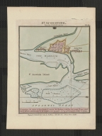
S. Augustin
Year
1588
Author
Boazio, Giovanni Battista
Short Title
A map of the southern section of the United States including the Floridas & Bahama islands shewing the seat of war, in that department.
Year
1813
Author
John Melish
Short Title
A Map of Part of West Florida, from Pensacola to the Mouth of the Iberville River, with a View to Shew the Proper Spot for a Settlement on the Mississipi
Year
1772
Author
John Lodge
Short Title
No. 1 A Map of Part of Alabama & Florida. Shewing the route of the proposed Columbus & Pensacola Rail Road.
Year
1836
Author
William R. Palmer
Short Title
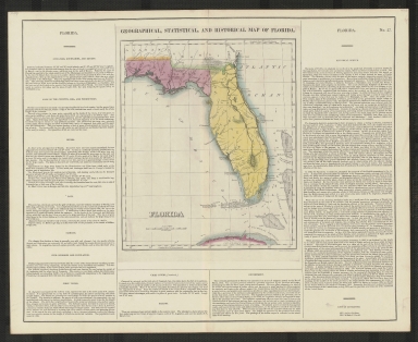
Geographical, Statistical, and Historical Map of Florida
Year
1823
Author
F. Lucas Jr.
Short Title
Geographisch-statistische und historische Charte von Florida
Year
1823
Author
Weiland, C. F.
Short Title
Geographical, Statistical, and Historical Map of Florida
Year
1827
Author
J. Drayton
Short Title
Official Map of the City of Tampa Florida and Vicinity
Year
1940
Short Title
Official Map of the City of Tampa Florida and Vicinity
Year
1940
Short Title
Official Map of the City of Tampa Florida and Vicinity
Year
1940
Short Title
Official Map of the City of Tampa Florida and Vicinity
Year
1940
Short Title
Tampa, Hillsborough County, Florida
Date Range
1960-1968
Author
Greater Tampa Chamber of Commerce
Short Title
Partie méridionale de la rivière de Missisipi, et ses environs, dans l'Amérique Septentrionale.
Year
1718
Author
Nicolas de Fer
Short Title
Detail Map of Tampa, Clearwater, St. Petersburg & Vicinity
Date Range
ca. 1934
Short Title
Sectional map of our New Lithia Lands, suburban to Tampa in Hillsboro County, Florida.
Date Range
ca. 1918/1922
Author
North Tampa Land Co.
Short Title
Sectional map of our New Lithia Lands, suburban to Tampa in Hillsboro County, Florida.
Date Range
ca. 1918/1922
Author
North Tampa Land Co.
Short Title
Map of North America Showing Direct Passenger Transportation Lines between the United States, Mexico, The West Indies, Central and South America, also Illustrating the Geographical position of Florida and Location of the Railroad, Steamboat and Steamship Lines of the Plant System for Commerce with other States and the Countries South and East of the Gulf of Mexico
Year
1889
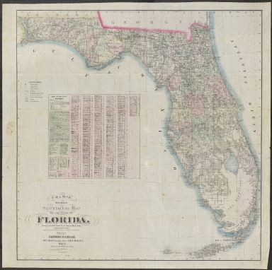
Short Title
Cram's New Indexed Sectional Map of the State of Florida, Showing Private and Government Grants, Prairie, Sawgrass Marsh, Swamp, and Hammock Lands. Compiled from official Records of the General Land Office and other Sources
Year
1884
Short Title
Port et Barre D'Amelia de la Floride Orientale
Year
1778
Date Range
1775-1778
Author
Georges Louis Le Rouge
Short Title
Carte réduite des costes de la Louisiane et de la Floride.
Year
1764
Author
Jacques Nicolas Bellin
Short Title
Location of the Clark Syndicate Lands & Enterprises
Author
C. T & C. R. R
Short Title
Location of the Clark Syndicate Lands & Enterprises
Author
C. T & C. R. R
Short Title
Location of the Clark Syndicate Farming Lands and Enterprises
|