|
REFINE
Browse All : Images by J. C. Ives
1-4 of 4
Short Title
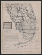
Military map of the Peninsula of Florida South of Tampa Bay, Compiled from the latest and most reliable authorities Map-overlay- present day roads and cities in relation to those of 1856.
Year
1856
Author
J. C. Ives
Short Title
Military map of the Peninsula of Florida South of Tampa Bay, Compiled from the latest and most reliable authorities Map-overlay- present day roads and cities in relation to those of 1856.
Year
1856
Author
J. C. Ives
Short Title
Military map of the Peninsula of Florida South of Tampa Bay, Compiled from the latest and most reliable authorities Map-overlay- present day roads and cities in relation to those of 1856.
Year
1856
Author
J. C. Ives
1-4 of 4
|