|
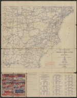
Short Title
Rand McNally Official 1922 Auto Trails Map District No. 21 State of Florida
Year
1922
Short Title
Rand McNally Official 1922 Auto Trails Map District No. 21 State of Florida
Year
1922
Short Title
Official Road Map of Florida
Year
1929
Author
Florida State Road Department
Short Title
Official Road Map of Florida
Year
1929
Author
Florida State Road Department
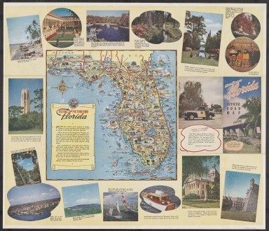
Short Title
Florida featuring Walt Disney World Your Hertz Travel Map & Tour Planner
Year
1971
Short Title
Florida featuring Walt Disney World Your Hertz Travel Map & Tour Planner
Year
1971
Short Title
Mappa Geographica Regionem Mexicanam et Floridam
Year
1756
Author
Tobias Conrad Lotter
Short Title
Sectional Map of St. Andrews Bay
Year
1887
Short Title
Sectional Map of St. Andrews Bay
Year
1887
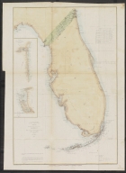
Short Title
U. S. Coast Survey A. D. Bache Superintendent Sketch F Showing the progress of the survey in Section VI with a general reconnoissance of the Coast of Florida 1848-61. 1861
Year
1861
Short Title
Plan de la baye de pensacola dans la Floride
Short Title
Plan de la baye de pensacola dans la Floride
Short Title
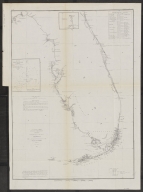
Ensign and Thayer Map titled Southern Part of Florida 1845
Year
1845
Short Title
Aerial photo map taken by space shuttle discovery nasa titled Florida 190 nautical miles. Space Graphics Winter Park, FL.
Short Title
G. W. and C. B. Colton Map of �FLORIDA�. Page 50. Discussion of Florida and Alabama on unnumbered verso pages; note reference in the discussions to the date of each state�s secession in 1861. Railroads are beginning to appear in north Florida. Interlocki
Year
1868
Short Title
G. W. and C. B. Colton Map of �FLORIDA�. Page 50. Discussion of Florida and Alabama on unnumbered verso pages; note reference in the discussions to the date of each state�s secession in 1861. Railroads are beginning to appear in north Florida. Interlocki
Year
1868
Short Title
Geological Map of the United States and Part of Canada Compiled by C. H. Hitchcock for the American Institute of Mining Engineers to Illustrate the Schemes of Coloration and Nomenclature Recommended by the International Geological Congress **the first ge
Year
1886
Short Title
Tourist Information Map All About U S 41 The Nation�s Main Street from The Great Midwest to Florida. A large inset Road Map of United States shows the route of U. S. 41 in red. There are many local advertisements of accommodations and services with accom
Year
1961
Short Title
Tourist Information Map All About U S 41 The Nation�s Main Street from The Great Midwest to Florida. A large inset Road Map of United States shows the route of U. S. 41 in red. There are many local advertisements of accommodations and services with accom
Year
1961
Short Title
Latest Map of Winter Haven and Lake Wales Florida With Street Index and Information. The two individual maps were Drawn by J. R. S., and the map was Distributed by Lakeland News Co. although copyrighted by Interstate Publishing Co. Inc. of Everett, Mass.
Date Range
1950s
Short Title
Latest Map of Winter Haven and Lake Wales Florida With Street Index and Information. The two individual maps were Drawn by J. R. S., and the map was Distributed by Lakeland News Co. although copyrighted by Interstate Publishing Co. Inc. of Everett, Mass.
Date Range
1950s
Short Title
The Motor Roads of Florida Compiled and Published by General Drafting Co., Inc. 1925 census information is included. An early road map of Florida � with a map on verso of The Main Thoroughfares of Eastern United States with Particular Reference to Florid
Year
1926
Short Title
The Motor Roads of Florida Compiled and Published by General Drafting Co., Inc. 1925 census information is included. An early road map of Florida � with a map on verso of The Main Thoroughfares of Eastern United States with Particular Reference to Florid
Year
1926
Short Title
Eustis Florida City Map and Classified Business Directory Frank Palmer. A small inset map of Florida locates The Orange Blossom Trail. Verso map is of Lake County. One of the advertisements is for a Deer Tongue Buyer.
Year
1939
Short Title
Eustis Florida City Map and Classified Business Directory Frank Palmer. A small inset map of Florida locates The Orange Blossom Trail. Verso map is of Lake County. One of the advertisements is for a Deer Tongue Buyer.
Year
1939
Short Title
Historical Reference Map of the State of Florida. The last event date shown is 1930, but the listing of Florida�s Governors shows Doyle Carlton�s term as 1929-1933. See the note at Charlotte Harbor which states, De Narvaez landed here in 1528 and took po
Date Range
1930s
Short Title
Envelope originally containing map 2019.026.008.001
Date Range
1930s
Short Title
A Guide Map to Geologic and Paleontologic Sites in Florida
Year
1989
Author
Frank R. Rupert
Short Title
A Guide Map to Geologic and Paleontologic Sites in Florida
Year
1989
Author
Frank R. Rupert
Short Title
Sketch F Showing the Progress of the Survey in Section VI With a General Reconnaissance of the Western Coast of Florida
Year
1852
Date Range
1848-52
Author
A. D. Bache
Short Title
Sketch F Showing the Progress of the Survey in Section VI With a General Reconnaissance of the Coast of Florida
Year
1854
Date Range
1848-54
Author
A. D. Bache
Short Title
Sketch F Showing the Progress of the Survey in Section VI With a General Reconnaissance of the Coast of Florida
Year
1860
Date Range
1848-60
Author
A. D. Bache
Short Title
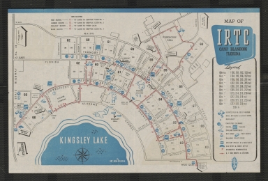
Handbook containing "Map of IRTC, Camp Blanding, Florida"
Year
1944
Short Title
Texaco Road Map Alabama Georgia Florida Cuba. One side is Rand McNally map of Florida with ten insets of Florida cities � also a map of Cuba. Verso is map of Alabama and Georgia and Florida panhandle.
Year
1933
Short Title
Texaco Road Map Alabama Georgia Florida Cuba. One side is Rand McNally map of Florida with ten insets of Florida cities � also a map of Cuba. Verso is map of Alabama and Georgia and Florida panhandle.
Year
1933
Short Title
3 Maps in 1 Jacksonville And Environs With Street Index [-] The Beach Cities [-] Road and Sectional Map of Duval County Florida.
Short Title
3 Maps in 1 Jacksonville And Environs With Street Index [-] The Beach Cities [-] Road and Sectional Map of Duval County Florida.
Short Title
3 Maps in 1 Jacksonville And Environs With Street Index [-] The Beach Cities [-] Road and Sectional Map of Duval County Florida.
Short Title
Tampa, USGS, NG 17-14. Coverage area extends from Clearwater to south of Sanibel Island, including Sarasota, Bradenton, St. Petersburg, and the Temporary Explosives Anchorage south of Port Tampa.
Year
1960
Short Title
Map of Palm Beach, Dolph. Fold-out street plan published by real estate broker Trevor C. Howell. Locates Lido Pools, Palm Beach Pier, Graham-Eckes School, Surfside Hotel, Paramount Theater, Embassy Club, South Bridge, and other landmarks, as well as pa
Year
1947
Short Title
Map of Palm Beach, Dolph. Fold-out street plan published by real estate broker Trevor C. Howell. Locates Lido Pools, Palm Beach Pier, Graham-Eckes School, Surfside Hotel, Paramount Theater, Embassy Club, South Bridge, and other landmarks, as well as pa
Year
1947
Short Title
Georgia & Florida, Adam & Charles Black. Handsome color lithographed map of Florida and Georgia, Drawn by John Bartholomew. Shows railways, wagon roads, towns, forts, and natural features, including the Alpatiokee Swamp. Dade county extends north to th
Year
1879
Short Title
Tunison's Florida, Henry Cuthbert Tunison. Labels 39 counties and shows completed and proposed railroads, including the Florida Railway & Navigation Company line ot Charlotte Harbor and the South Flroida narrow-gauge to Tampa. Inset: Mouths of the Missi
Year
1885
|


![3 Maps in 1 Jacksonville And Environs With Street Index [-] The Beach Cities [-] Road and Sectional Map of Duval County Florida.](https://luna.tampabayhistorycenter.org/MediaManager/srvr?mediafile=/Size1/TBHC~3~3/111/2019.026.021-01.jpg)
![3 Maps in 1 Jacksonville And Environs With Street Index [-] The Beach Cities [-] Road and Sectional Map of Duval County Florida.](https://luna.tampabayhistorycenter.org/MediaManager/srvr?mediafile=/Size1/TBHC~3~3/111/2019.026.021-02.jpg)
![3 Maps in 1 Jacksonville And Environs With Street Index [-] The Beach Cities [-] Road and Sectional Map of Duval County Florida.](https://luna.tampabayhistorycenter.org/MediaManager/srvr?mediafile=/Size1/TBHC~3~3/111/2019.026.021-03.jpg)


