|
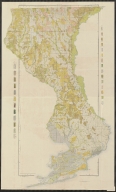
Short Title
Florida.
Year
1908
Author
Rand McNally and Company
Short Title
Florida.
Year
1908
Author
Rand McNally and Company
Short Title
Soil map : Florida, Ocala sheet.
Year
1912
Author
U.S. Dept. of Agriculture Bureau of Soils
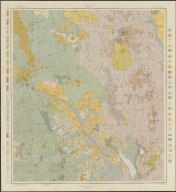
Short Title
Soil map : Florida, Escambia County sheet.
Year
1906
Author
U.S. Dept. of Agriculture Bureau of Soils
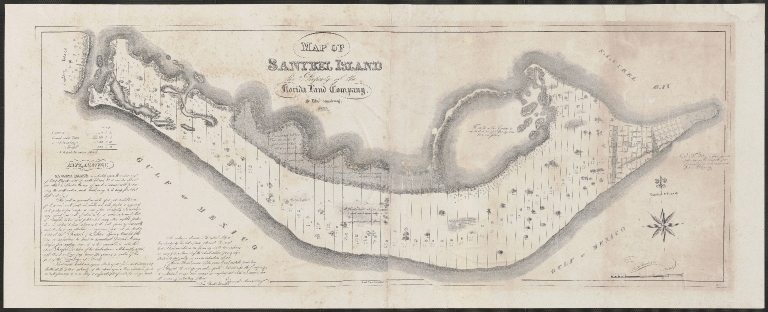
Short Title
Map of Sanybel Island
Year
1833
Author
Edward Armstrong
Short Title
Map of a part of the United States showing the quantity of each variety of iron ore produced in each county during the Census year. Plate XVII. Sheet No 3. Tenth Census of the United States. Department of the Interior.
Year
1880
Short Title
Map of Ocean Front Property of The Miami Beach Improvement Company
Date Range
1913-1916
Short Title
Plan of the New City of Pensacola from recent and accurate survey
Year
1836
Author
G.E. Chase
Short Title
Lower Tampa Bay Boater's Guide sponsored by Audubon Florida
Date Range
2016-2017
Short Title
Lower Tampa Bay Boater's Guide sponsored by Audubon Florida
Date Range
2016-2017
Short Title
A new chart of the Bahama Islands, Part of Florida Cuba and Hispaniola
Year
1769
Short Title
Untitled chart of the Florida peninsula and the western coast of the Gulf of Mexico
Year
1769
Short Title
Ottoman-Turkish map of Florida and the West Indies which also shows most of the peninsula of Florida from just above Tampa Bay
Year
1893
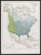
Short Title
Map showing the natural divisions of the north american forests exclusive of mexico
Year
1884
Author
Harry Kind
Short Title
Map of the Florida East Coast Railway Flagler System Florida's Only Double Track Route
Year
1948
Short Title
Map of the Florida East Coast Railway Flagler System Florida's Only Double Track Route
Year
1948
Short Title
Manuscript map of St. Augustine
Date Range
1861-1865
Author
Unknown
Short Title
Map of the United States, Commercial Products
Year
1903
Author
Rand, McNally & Company
Short Title
Rand, McNally & Co.'s indexed atlas of the world map of Florida.
Year
1892
Author
Rand McNally and Company
Short Title
Rand, McNally & Co.'s indexed atlas of the world map of Florida.
Year
1892
Author
Rand McNally and Company
Short Title
Florida Geological Survey Map
Year
1929
Short Title
North Atlantic Ocean Steamship Routes and Distances
Year
1915
Short Title
Tampa Map of Business Section Guide to Points of Interest Facts and Figures
Year
1926
Short Title
Tampa Map of Business Section Guide to Points of Interest Facts and Figures
Year
1926
Short Title
Florida East Coast Railway Jacksonville via St. Augustine, Ormond, Palm Beach and Miami to Key West and Havana
Year
1911
Short Title
Florida East Coast Railway Jacksonville via St. Augustine, Ormond, Palm Beach and Miami to Key West and Havana
Year
1911
Short Title
Map of Tampa’s Street Car System
Short Title
Map of Tampa’s Street Car System
Short Title
Florida.
Year
1904
Author
Rand McNally and Company
Short Title
Florida.
Year
1904
Author
Rand McNally and Company
Short Title
The North Coast of the Gulf of Mexico, from St. Marks to Galveston
Year
1844
Author
E & G. W. Blunt
Short Title
St. Marks to Galveston Sheet II
Year
1846
Author
E & G. W. Blunt
Short Title
Eldridge's Chart, No. 9. St. Augustine to New Orleans, with Florida Reefs and Entrance to Pensacola and Mobile Bays on a large scale
Year
1872
Author
George Eldridge
Short Title
Florida East Coast Railway copper plate (possibly a stereotyple plate). Used to create "Florida East Coast Railway Jacksonville via St. Augustine, Ormond, Palm Beach and Miami to Key West and Havana"
Short Title
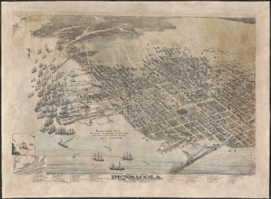
Bird's Eye view of Pensacola, County Seat of Escambia County, Florida. The Only Natural Deep Harbor on the Gulf.
Year
1896
Author
Augustus Koch
Short Title
America - Septentrional. Costa Este. Hoja I. Florida con los Canales de Bahama y Providencia, segun los trabajos mas fidedignos nacionales y extrajeros.
Year
1867
Author
Direccion de Hidrografia
Short Title
Florida.
Year
1904
Author
Rand McNally and Company
Short Title
Florida.
Year
1904
Author
Rand McNally and Company
|