WHERE
-
[Map of southern Florida
…
(1)
-
[Pensacola and Mobile are
…
(2)
-
[Pensacola-Mobile area]
(4)
-
[Pensacola-Mobile area].
(2)
-
[Pensacola-Mobile region]
(4)
-
[Pensacola-Mobile region]
…
(2)
-
A Draught of Spirito Sanc
…
(2)
-
A Plan of Pensacola Harbo
…
(1)
-
A Plan of Pensacola Harbo
…
(1)
-
Abaco Island
(1)
-
Africa
(3)
-
Alabama
(29)
-
Alachua
(7)
-
Alachua; Hillsborough
(2)
-
Altamonte Springs
(1)
-
Amelia Island
(2)
-
Anclote Keys
(1)
-
Anna Maria
(1)
-
Apalachicola
(4)
-
Apalachicola River
(1)
-
Apalachicola River area
(2)
-
Aripeka
(2)
-
Arkansas
(1)
-
Asia
(3)
-
At left top inset-Florida
…
(1)
-
Atlantic Coast
(2)
-
Atlantic Coast (Fla.)
(3)
-
Atlantic Coast (U.S.)
(9)
-
Atlantic Intracoastal Wat
…
(1)
-
Atlantic Ocean
(2)
-
Atlantic Ocean; Caribbean
(1)
-
Atlantic Ocean; Gulf of M
…
(1)
-
Atlantic States
(4)
-
Avon Park
(1)
-
Azores
(1)
-
Bahama Islands
(1)
-
Bahamas
(30)
-
Bahia de Matanças int Gr
…
(1)
-
Bahia Honda
(1)
-
Baja Honda int Groodt.
(1)
-
Baker
(2)
-
Baldwin
(2)
-
Banana River
(1)
-
Bar & Entrance of Mobile
…
(1)
-
Bar & Entrance of Pensaco
…
(1)
-
Battle ground of Major Da
…
(2)
-
Battle ground of Major Da
…
(1)
-
Battle ground of Major Da
…
(1)
-
Bay
(2)
-
Bermuda Islands
(1)
-
Big Cypress
(1)
-
Big Pine Key
(2)
-
Black and white map showi
…
(1)
-
Black Hammock Island
(1)
-
Boca Grande
(1)
-
Boca Raton
(3)
-
Border States
(2)
-
Bottom inset: Tampa Bay S
…
(1)
-
bottom portion of Florida
(1)
-
bottom portion of Texas
(1)
-
Braden River
(2)
-
Bradenton
(3)
-
Bradford
(1)
-
Brandon
(2)
-
Brandon Area
(2)
-
Brazil; Cuba; Jamaica; Ba
…
(2)
-
Brevard
(4)
-
Brighton
(1)
-
British East and West Flo
…
(1)
-
British East Florida
(1)
-
Broward
(8)
-
Broward County
(2)
-
Caloosahatchee River
(1)
-
Camp Blanding
(2)
-
Canada
(6)
-
Canal de Bahama
(1)
-
Cape Canaveral
(1)
-
Cape Sable
(1)
-
Caribbean
(2)
-
Caribbean Area
(9)
-
Caribbean; Gulf of Mexico
…
(1)
-
Caroline
(1)
-
Carrabelle
(1)
-
Carte des embouchures du
…
(1)
-
Casey Key
(2)
-
Casselberry
(1)
-
Cedar Key
(1)
-
Cedar Keys
(1)
-
Central America
(6)
-
Central Florida
(2)
-
Central St. Petersburg.
(2)
-
Central Tampa.
(2)
-
Charleston and vicinity
(3)
-
Charleston Harbor
(1)
-
Charlotte
(4)
-
Charlotte Harbor (Bay)
(1)
-
Charlotte Harbor; Sanibel
…
(1)
-
Chart of the currents in
…
(1)
-
Chart of the Eads Jetty S
…
(1)
-
Chart of the mouths of th
…
(3)
-
Chuluota
(1)
-
Citrus
(1)
-
City
(1)
-
City of Temple Terrace.
(4)
-
Civic Center Area
(2)
-
Clay
(3)
-
Clay County
(1)
-
Clearwater
(6)
-
Clermont
(1)
-
Coffin's Patches
(1)
-
Collier
(2)
-
Collier County
(1)
-
Colombia
(1)
-
Color illustration, "Capt
…
(1)
-
Color illustration, "Capt
…
(1)
-
Color illustration, "Exto
…
(1)
-
Color illustration, "The
…
(1)
-
Color illustration, "Then
…
(1)
-
Color illustration, Buffi
…
(1)
-
Color illustration, Judso
…
(1)
-
Color illustration, pirat
…
(1)
-
Color illustration, Sammi
…
(1)
-
Color illustration, two s
…
(1)
-
Color illustration,"Who s
…
(1)
-
Columbia
(2)
-
Comparative elevation of
…
(1)
-
Continuation of Florida
(7)
-
Continuation of Florida.
(3)
-
Continuation of northwest
…
(1)
-
Continuation of Pass-a-Gr
…
(1)
-
Continuation of the Coast
…
(1)
-
Continuation of western F
…
(2)
-
Coral Gables
(3)
-
Costa Rica
(1)
-
Cotee Lake
(1)
-
County Map of North Carol
…
(1)
-
Cross Florida Barge Canal
(2)
-
Crystal River
(1)
-
Cuba
(50)
-
Cuba.
(2)
-
Cuba; Dominican Republic;
…
(1)
-
Cumberland lsland
(1)
-
Cumberland Sound
(2)
-
Dade Battlefield
(1)
-
Dade Battlefield Historic
…
(2)
-
Dade City
(2)
-
Dade County
(2)
-
Dade; Miami Dade
(1)
-
Daytona Beach Shores
(1)
-
Daytona Beach
(7)
-
De Land
(3)
-
De Soto
(10)
-
Deerfield Beach
(2)
-
Del Ray Beach
(1)
-
DeLand
(1)
-
Delray Beach
(2)
-
Der Niagara-Fall und sein
…
(1)
-
Der südliche Teil von Fl
…
(1)
-
Der südliche Teil von Te
…
(1)
-
Distances to Miami
(4)
-
Distances to Miami.
(4)
-
Dixie Highway
(2)
-
Dominican Republic
(2)
-
Downtown Tampa
(8)
-
downtown Tampa
(1)
-
Downtown Tampa.
(22)
-
Dry Tortugas
(36)
-
Dry Tortugas.
(37)
-
Du Noveau Mexique
(1)
-
Dunedin
(2)
-
Duval
(11)
-
Dètroit de la Floride
(1)
-
East (U.S)
(1)
-
East (U.S.)
(1)
-
East Coast of Florida; Ev
…
(2)
-
East Florida
(3)
-
East Florida; West Florid
…
(1)
-
East Tampa
(1)
-
Eastern Entrance to St. G
…
(1)
-
Eastern entrance to St. R
…
(1)
-
Eastern Hemisphere
(1)
-
Eastern portion of the Un
…
(1)
-
Eastern portion of the Un
…
(2)
-
Eastern U.S.
(1)
-
Eastern United States
(2)
-
Eastern United States; At
…
(1)
-
eight regional insets
(2)
-
England
(1)
-
Englewood
(1)
-
Enlarged map of the Tampa
…
(2)
-
Enlarged map of the Tampa
…
(2)
-
Enlarged plan of Pensacol
…
(1)
-
Entrance to Appalachicola
…
(1)
-
Entrance to Mobile Bay Lt
…
(1)
-
Entrance to Ocklockony Ba
…
(1)
-
Entrance to Pensacola Bay
…
(1)
-
Entrance to St. Augustine
…
(1)
-
Entrance to St. John's Ri
…
(1)
-
Entrance to St. Joseph's
…
(1)
-
Entrance to St. Mary's Ha
…
(1)
-
Entrances to St. Andrew's
…
(1)
-
Escambia
(15)
-
Escambia; Monroe
(1)
-
Europe
(6)
-
Europe; Asia; Africa
(3)
-
Evan's Polymetric Table o
…
(1)
-
Everglades
(3)
-
Everglades and Key West
(1)
-
Everglades National Park
(1)
-
Extension of the larger m
…
(1)
-
Fanning Island
(1)
-
Fern Park
(1)
-
Fernandina
(1)
-
Fernandina Beach
(1)
-
Fernandina; Amelia Island
(1)
-
Five road maps showing ho
…
(2)
-
Florida
(1279)
-
Florida (Western section)
(2)
-
Florida and the east coas
…
(2)
-
Florida City
(1)
-
Florida East Coast
(1)
-
Florida Keys
(22)
-
Florida Keys.
(11)
-
Florida Ocidental
(1)
-
Florida Oriental
(1)
-
Florida Panhandle
(9)
-
Florida panhandle
(2)
-
Florida Panhandle; Florid
…
(1)
-
Florida Panhandle; northe
…
(1)
-
Florida Panhandle; northe
…
(1)
-
Florida peninsula
(1)
-
Florida Straits
(1)
-
Florida Territory
(5)
-
Florida West Coast
(2)
-
Florida | Georgia
(2)
-
Florida, Straits of
(1)
-
Florida-Georgia border
(1)
-
Florida; East Florida; We
…
(1)
-
Florida; Georgia
(1)
-
Florida; Georgia; Alabama
(1)
-
Florida; Georgia; Alabama
…
(1)
-
Florida; Georgia; Alabama
…
(2)
-
Florida; Georgia; Alabama
…
(1)
-
Florida; Georgia; South C
…
(3)
-
Florida; Georgia; South C
…
(1)
-
Florida; Georgia; South C
…
(1)
-
Florida; Georgia; South C
…
(1)
-
Floride Occidentale
(1)
-
Floride Orientale
(1)
-
Forest City
(1)
-
Forest Hills - Babe Zahar
…
(2)
-
Forme des balises.
(1)
-
Fort Dallas Park
(2)
-
Fort Lauderdale
(3)
-
Fort Myers
(2)
-
Fort Pierce
(1)
-
Four inset maps show the
…
(1)
-
Franklin
(9)
-
Gadsden
(2)
-
Gandy Bridge
(6)
-
Gateway to Pan America
(2)
-
General map of part of Fl
…
(1)
-
General Map of Part of Fl
…
(1)
-
Geneva
(1)
-
Georgia
(37)
-
Georgia; Florida
(1)
-
Georgia; Florida; Louisia
…
(1)
-
Georgie
(1)
-
Glades
(1)
-
Goldenrod
(1)
-
Green Cove Springs
(1)
-
Greenland
(1)
-
Grove City
(1)
-
Guatemala
(1)
-
Gulf Coast
(1)
-
Gulf Coast (Fla.)
(12)
-
Gulf Coast (Mexico)
(8)
-
Gulf Coast (U.S.)
(19)
-
Gulf of Mexico
(7)
-
Gulf of Mexico; Caribbean
…
(2)
-
Gulf of Mexico; Mexico Ci
…
(1)
-
Gulf States
(4)
-
Gulf Stream
(1)
-
Gulfport
(3)
-
Haines City
(2)
-
Haiti
(2)
-
Halifax River
(2)
-
Harbour of St. Augustine
(5)
-
Harbour of St. Augustine.
(1)
-
Hardee
(2)
-
Havana int Groodt.
(1)
-
Hernando
(3)
-
Highlands
(8)
-
Hilliard
(1)
-
Hillsboro River Drainage
…
(1)
-
Hillsborough
(170)
-
Hillsborough Bay
(3)
-
Hillsborough County
(12)
-
Hillsborough River
(1)
-
Hillsborough; Pinellas
(1)
-
Hilsboro Bay
(1)
-
Hispaniola
(2)
-
Hispanola
(1)
-
Hollywood
(2)
-
Holmes Beach
(1)
-
Holy Hill
(1)
-
Homestead
(2)
-
Homosassa
(1)
-
Honduras
(1)
-
Hours to St. Petersburg f
…
(2)
-
Hudson
(3)
-
Hudson Creek
(1)
-
Ile Ameila
(1)
-
Ile Cumberland
(1)
-
Ile Tiger
(1)
-
Index to Adjoining Sheets
(1)
-
Index to Boundaries
(1)
-
Indian River
(5)
-
Indian River (Lagoon)
(5)
-
Indian River County
(5)
-
Indian Rocks Beach
(2)
-
inset at the lower left c
…
(2)
-
Inset Chart of Key West b
…
(2)
-
Inset maps feature Key We
…
(1)
-
Inset of western Panhandl
…
(1)
-
Inset shows map of Florid
…
(1)
-
Isla de Cuba
(2)
-
Isla de Santo Domingo
(2)
-
Isla Jamayca
(2)
-
Islamorada
(1)
-
Island of New Found Land
(1)
-
Islas Lucayas o de Bahama
(2)
-
Isthmus of Tehuantepec
(1)
-
Jackson
(2)
-
Jacksonville
(20)
-
Jacksonville and Vicinity
(4)
-
Jacksonville and vicinity
(2)
-
Jacksonville to Saint Aug
…
(1)
-
Jacksonville-St. Augustin
…
(3)
-
Jacksonville; Palatka; Ma
…
(1)
-
Jamaica
(10)
-
Jefferson
(1)
-
Jessamine
(1)
-
Jucatan
(1)
-
Jupiter Island
(1)
-
Kennedy Space Center
(2)
-
Kentucky
(4)
-
Key West
(16)
-
Key West as Surveyed Febr
…
(1)
-
Kissimmee
(1)
-
Kissimmee River
(1)
-
Lafayette
(2)
-
Lake
(3)
-
Lake City
(1)
-
Lake County
(4)
-
Lake Mary
(1)
-
Lake Okeechobee
(1)
-
Lake Panasoffkee
(2)
-
Lake Superior
(1)
-
Lake Wales
(3)
-
Lake Worth
(1)
-
Lakeland
(16)
-
Lanark
(2)
-
Largo
(2)
-
Laurel
(1)
-
Lee
(2)
-
Lee County
(3)
-
Leesburg
(2)
-
Lemon Bay
(1)
-
Leo
(1)
-
Leon
(4)
-
Leroy
(9)
-
Les Bermudes
(1)
-
Les costes de la Louisian
…
(1)
-
Levy
(4)
-
Location map : from U.S.C
…
(3)
-
Location map showing Pine
…
(1)
-
Location map, map of Flor
…
(2)
-
Longwood
(1)
-
Looking South from Post O
…
(1)
-
Louisiana
(16)
-
Louisiane
(1)
-
lower peninsula of Florid
…
(1)
-
Lynn Haven
(2)
-
Main Entrance to St. Geor
…
(1)
-
Main entrance to St. Geor
…
(1)
-
Main highways in eastern
…
(1)
-
Maine
(2)
-
Manatee
(16)
-
Manatee River
(4)
-
Map of Florida and the We
…
(9)
-
Map of Florida Panhandle
…
(1)
-
Map of Florida Panhandle.
(2)
-
Map of Florida with steam
…
(1)
-
Map of Greyhound routes t
…
(4)
-
Map of Lee County, Florid
…
(2)
-
Map of North America sout
…
(2)
-
Map of northwest Florida.
(4)
-
Map of northwestern Flori
…
(4)
-
Map of peninsular Florida
…
(1)
-
Map of routes through Geo
…
(2)
-
Map of South Carolina
(1)
-
Map of South Carolina wit
…
(1)
-
Map of southern Florida.
(1)
-
Map of Tampa area (100 mi
…
(4)
-
Map of the Florida Keys a
…
(1)
-
Map showing Georgia, Flor
…
(1)
-
Map showing lines of tran
…
(2)
-
Map showing part of Lake,
…
(1)
-
Map showing part of Lake,
…
(6)
-
Map showing parts of Lake
…
(8)
-
Map showing parts of Lake
…
(2)
-
Map Showing Parts of Lake
…
(1)
-
Map showing parts of Lake
…
(4)
-
Map showing parts of Lake
…
(4)
-
Map showing parts of Lake
…
(2)
-
Map showing parts of Lake
…
(1)
-
Map showing parts of Lake
…
(1)
-
Map showing parts of Lake
…
(2)
-
Map showing parts of Lake
…
(1)
-
Map Showing the Relation
…
(1)
-
Maps Showing the Florida
…
(1)
-
Marianna
(1)
-
Marion
(20)
-
Martin
(2)
-
Merritt Island
(2)
-
Mexico
(20)
-
Mexico, Gulf of
(2)
-
Miami
(32)
-
Miami and Miami Beach
(4)
-
Miami and Vicinity
(4)
-
Miami and vicinity
(4)
-
Miami Beach
(28)
-
Miami Metropolitan Area
(2)
-
Miami-Dade
(29)
-
Miami-Dade County
(2)
-
Miami; Miami Beach
(1)
-
Middle Atlantic States
(3)
-
Middle entrance to St. Ge
…
(1)
-
Middle inset-Old Hillsbor
…
(1)
-
Middle West
(1)
-
Mississippi
(8)
-
Mississippi River
(1)
-
Missouri
(1)
-
Mobile
(9)
-
Mobile.
(5)
-
Monroe
(18)
-
Monroe County
(1)
-
Mosquito Lagoon
(1)
-
Mouths of the Suwanee Riv
…
(1)
-
Mullet Key and vicinity.
(2)
-
Murdock
(1)
-
Myakka City
(1)
-
Myakka River
(1)
-
Nassau
(8)
-
Nassau County
(2)
-
Nassau River
(2)
-
National trails east of t
…
(2)
-
New England
(1)
-
New Mexico
(1)
-
New Port Comfort
(1)
-
New Port Richey
(1)
-
New Providence
(1)
-
New Smyrna
(1)
-
New York
(1)
-
Nicaragua
(1)
-
Nokomis
(1)
-
None
(2)
-
North America
(1370)
-
North America (Caribbean
…
(1)
-
North America; Atlantic O
…
(1)
-
North America; Central Am
…
(1)
-
North America; Europe (sm
…
(1)
-
North America; South Amer
…
(4)
-
North America; South Amer
…
(2)
-
North American continent
…
(1)
-
North Carolina
(13)
-
North Florida
(1)
-
North Orlando
(1)
-
North Palm Beach
(1)
-
North western part of Flo
…
(1)
-
North Western Portion of
…
(1)
-
North western portion of
…
(1)
-
North-western part of Flo
…
(1)
-
North-western portion of
…
(19)
-
North-Western portion of
…
(13)
-
North-Western Portion of
…
(1)
-
North-western portion of
…
(32)
-
northeast Florida
(2)
-
Northeast Florida
(1)
-
northeast Florida; Britis
…
(1)
-
northeast Florida; Britis
…
(1)
-
Northeast Florida; Territ
…
(1)
-
Northern Gulf Coast; Gulf
…
(1)
-
Northwest Florida
(4)
-
Northwest Passage
(1)
-
Northwestern portion of
…
(2)
-
Northwestern Florida
(6)
-
Northwestern Florida.
(2)
-
Northwestern Part of Flor
…
(4)
-
Northwestern part of Flor
…
(3)
-
Northwestern part of Flor
…
(2)
-
Northwestern part of stat
…
(4)
-
Northwestern portion of
…
(13)
-
Northwestern portion of
…
(34)
-
Nouveau Royaume de Leon
(1)
-
Nova Scotia
(1)
-
Ocala
(1)
-
Ochlockonee River; Ochloc
…
(1)
-
Old Spanish Trail
(1)
-
Old Tampa Bay
(2)
-
Olustee; Ocean Pond; nort
…
(1)
-
Orange
(10)
-
Orange Park
(1)
-
Orlando
(9)
-
Ormond Beach
(3)
-
Osceola
(2)
-
Osprey
(1)
-
Oviedo
(1)
-
Palatka
(1)
-
Palm Beach
(9)
-
Palm Harbor
(1)
-
Palmetto
(1)
-
Panama
(3)
-
Panama City
(3)
-
Panhandle of Florida
(1)
-
Parte de la Ysla de Cuba
(1)
-
Pasco
(9)
-
Patrick Air Force Base
(2)
-
Peace River Valley
(1)
-
Pennsylvania
(3)
-
Pensacola
(27)
-
Pensacola Bay
(10)
-
Pensacola Bay Area
(1)
-
Pensacola Bay; Santa Rosa
…
(1)
-
Pensacola-Mobile area
(2)
-
Pensacola-Mobile region
(2)
-
Pensacola-Mobile region.
(6)
-
Pensacola.
(1)
-
Pensacola; Key West
(1)
-
Perdido Bay
(2)
-
Perrine
(1)
-
Pictorial representations
…
(1)
-
Pinellas
(54)
-
Pinellas County
(6)
-
Pinellas Park
(2)
-
Pinellas; Hillsborough; M
…
(1)
-
Placida
(1)
-
Plains States
(1)
-
Plamore
(1)
-
Plan for a new settlement
…
(1)
-
Plan of Charlestown
(1)
-
Plan of government survey
(2)
-
Plan of Grounds and Impro
…
(1)
-
Plan of Pensacola
(2)
-
Plan of St. Augustine
(1)
-
Plan of Tallahassee
(1)
-
Plan of the City of Talla
…
(1)
-
Plan of the Florida Keys
(6)
-
Plan of the Florida Keys
…
(15)
-
Plano de la Aguadilla
(2)
-
Plano del Baxo
(2)
-
Plant City
(1)
-
Polk
(23)
-
Ponce de Leon Inlet
(1)
-
Population of Incorporate
…
(2)
-
Port de Fernandina
(1)
-
Port Everglades
(1)
-
Port of Tampa; Tampa Bay;
…
(2)
-
Port Tampa
(6)
-
Port Tampa City
(1)
-
portion of Florida (Escam
…
(1)
-
portion of Mexico shown w
…
(1)
-
portion of western tip of
…
(1)
-
Principal Highways of Flo
…
(2)
-
Principal products and pr
…
(3)
-
Profile along the sailing
…
(1)
-
Profile along the sailing
…
(1)
-
Profile on line of propos
…
(1)
-
Province of Quebec
(1)
-
Provincia de Yucatan
(1)
-
Punta Gorda
(2)
-
Putnam
(2)
-
Quebec
(1)
-
Ravine State Gardens
(1)
-
Redington Beach
(2)
-
Redland District
(1)
-
Republic of Cuba
(2)
-
Ridgewood
(1)
-
Road map of Florida: From
…
(2)
-
Safety Harbor
(4)
-
Saint Augustine
(1)
-
Saint Johns
(2)
-
Saint Johns River
(14)
-
Saint Marys River
(3)
-
Saint Petersburg
(2)
-
Saint Petersburg Beach
(2)
-
Saint Sebastian River
(5)
-
Saint Vincent Island
(1)
-
Sanford
(1)
-
Sanibel
(1)
-
Sanlando Springs
(1)
-
Santa Rosa
(2)
-
Santa Rosa Island
(1)
-
Sarasota
(13)
-
Sarasota Bay
(2)
-
Savannah and vicinity
(3)
-
Seaboard Air Line around
…
(2)
-
Seabreeze
(2)
-
Sebring
(4)
-
Seminole
(3)
-
Seno Mexicano
(2)
-
Short Canal
(1)
-
Silver Springs
(5)
-
Sketch of Tortugas Island
…
(4)
-
South America
(12)
-
South Atlantic States
(11)
-
South Boundary of General
…
(1)
-
South Carolina
(19)
-
South Florida
(2)
-
South Florida; Southeast
…
(2)
-
South Tampa; Palma Ceia
(1)
-
South-Eastern Portion of
…
(2)
-
Southeast Florida
(1)
-
Southeast United States
(8)
-
Southeastern States
(1)
-
Southeastern United State
…
(3)
-
Southeastern United State
…
(2)
-
Southeastern United State
…
(1)
-
Southeastern United State
…
(1)
-
Southeastern United State
…
(1)
-
Southern Florida Keys.
(1)
-
Southern part of Florida.
(3)
-
Southern part of state
(3)
-
Southern part of state.
(2)
-
Southern part of the Pine
…
(2)
-
Southern portion of Flor
…
(28)
-
Southern portion of Flor
…
(22)
-
Southern portions of Flor
…
(1)
-
Southern States
(37)
-
Southern United States
(1)
-
Spain
(2)
-
Spain; France
(1)
-
Specimen Section official
…
(2)
-
St. Anastatia Island
(1)
-
St. Andrew Bay
(1)
-
St. Andrew's Bay
(2)
-
St. Andrew's Bay (spelled
…
(1)
-
St. Andrews; Gold Town; H
…
(1)
-
St. Augustine
(15)
-
St. Augustine, Ocklawaha
…
(2)
-
St. Augustine; Daytona Be
…
(2)
-
St. George's Island; Apal
…
(1)
-
St. John's River
(1)
-
St. Johns
(9)
-
St. Johns (present day)
(1)
-
St. Johns Cpunty
(1)
-
St. Johns River; northeas
…
(1)
-
St. Lucie
(1)
-
St. Marks River
(2)
-
St. Mary's River
(2)
-
St. Petersburg
(26)
-
St. Petersburg Beach
(1)
-
St. Petersburg; Clearwate
…
(1)
-
St. Petersburg; Gulfport;
…
(2)
-
St.Augustine
(1)
-
State of Florida
(5)
-
state of Florida
(2)
-
State of Florida; souther
…
(1)
-
Ste Marie
(1)
-
Steamship lines from Euro
…
(2)
-
Steamship Lines from Euro
…
(1)
-
Street map of St. Petersb
…
(2)
-
Street map of Tampa showi
…
(2)
-
Street maps of downtown f
…
(2)
-
Streets
(1)
-
Stuart
(1)
-
Sub Sketch Charlotte Harb
…
(1)
-
Sub Sketch of Cedar Keys
(2)
-
Sub sketch of Cedar Keys
(1)
-
Sub Sketch St. John's Riv
…
(1)
-
Sub-Sketch showing the pr
…
(1)
-
Sub-Sketch showing the pr
…
(1)
-
Sumter
(7)
-
Sunshine State Parkway
(2)
-
Supplemento alla Florida
…
(1)
-
Suwannee
(1)
-
Talbot Island
(1)
-
Tallahassee
(7)
-
Tallahassee.
(1)
-
Tampa
(176)
-
Tampa and St. Petersburg
(4)
-
Tampa Bay
(10)
-
Tampa Bay and Vicinity
(4)
-
Tampa Bay and vicinity
(2)
-
Tampa Bay Area
(3)
-
Tampa Bay Region
(5)
-
Tampa Bay Region (Fla.)
(1)
-
Tampa Bay; Fort Brooke
(2)
-
Tampa Bay; south end of t
…
(1)
-
Tampa International Airpo
…
(2)
-
Tampa, FL
(2)
-
Tampa- St. Petersburg dis
…
(2)
-
Tampa-St. Petersburg area
(2)
-
Tangerine
(2)
-
Tarpon Springs
(3)
-
Temple Terrace
(8)
-
Tennessee
(4)
-
Texas
(4)
-
The Bahamas
(1)
-
The coast and river line,
…
(1)
-
The eastern portion of No
…
(1)
-
The Gallapagos Islands
(1)
-
The known world according
…
(1)
-
Tierra Verde and Fort De
…
(2)
-
Titusville
(1)
-
Treasure Island
(3)
-
Two: Jamaica (spelled Iam
…
(1)
-
United Sates
(1)
-
United States
(1349)
-
United States map
(1)
-
United States of America
(5)
-
United States | Cuba
(2)
-
United States; British Co
…
(1)
-
United States; Canada; Me
…
(1)
-
United States; Confederat
…
(1)
-
United States; Cuba; Braz
…
(1)
-
United States; Cuba; Brit
…
(1)
-
United States; Cuba; Domi
…
(1)
-
United States; England
(1)
-
United States; France
(1)
-
United States; Great Brit
…
(2)
-
United States; Mexico; Ca
…
(1)
-
United States; Mexico; Cu
…
(1)
-
United States; Mexico; Cu
…
(1)
-
United States; Northeast;
…
(2)
-
United States; Spain
(1)
-
Unites States
(1)
-
Untitled inset of Florida
…
(1)
-
Venezuela
(1)
-
Venice
(1)
-
Vero Beach
(1)
-
Vicinity Map
(2)
-
View of Gun Cay Light Hou
…
(1)
-
View of Gun Cay Light Hou
…
(1)
-
Virginia
(2)
-
Volusia
(13)
-
Wabasso
(1)
-
Wakulla
(3)
-
Walton
(1)
-
Warrington
(1)
-
Washington; Bay
(1)
-
Washington; Calhoun; Bay
(3)
-
Waterfront of St. Augusti
…
(1)
-
Wauchula
(1)
-
Weekiwachee
(2)
-
West (U.S.)
(1)
-
West Central Florida; Gul
…
(1)
-
West Coast of Florida Anc
…
(1)
-
West Florida
(11)
-
West Indes
(1)
-
West Indies
(17)
-
West Indies and Central A
…
(1)
-
West Indies; Caribbean
(1)
-
West Palm Beach
(3)
-
West Palm Beach and Palm
…
(4)
-
West Palm Beach to Miami
…
(1)
-
West Part of Florida
(2)
-
West part of Florida
(1)
-
West part of Florida.
(2)
-
West Tampa
(1)
-
Western end of state
(2)
-
Western Florida
(29)
-
Western Florida.
(10)
-
Western part of Florida
(5)
-
Western Part of Florida
(1)
-
Western part of Florida.
(4)
-
Western part of state
(1)
-
Western part of state.
(4)
-
Western Portion of Florid
…
(4)
-
western tip of Florida
(1)
-
Westward Extension of Flo
…
(1)
-
Wilmington and vicinity
(3)
-
Windward Passage
(2)
-
Winter Haven
(5)
-
Winter Park
(2)
-
World
(2)
-
Ybor City
(1)
-
Zephyrhills
(3)
Less
|
Short Title
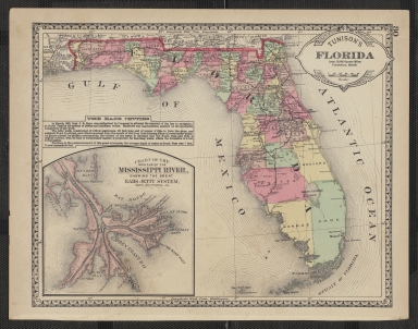
Tunison's Florida, Henry Cuthbert Tunison. Labels 39 counties and shows completed and proposed railroads, including the Florida Railway & Navigation Company line ot Charlotte Harbor and the South Flroida narrow-gauge to Tampa. Inset: Mouths of the Missi
Short Title
Tunison's Florida, Henry Cuthbert Tunison. Labels 39 counties and shows completed and proposed railroads, including the Florida Railway & Navigation Company line ot Charlotte Harbor and the South Flroida narrow-gauge to Tampa. Inset: Mouths of the Missi
Short Title
Tunison's Florida, Henry Cuthbert Tunison. Labels 39 counties and shows completed and proposed railroads, including the Florida Railway & Navigation Company line ot Charlotte Harbor and the South Flroida narrow-gauge to Tampa. Inset: Mouths of the Missi
Short Title
Tunison's Florida, Thompson & Thomas. Dade county extends north of Jupiter to a "proposed drainage canal" from Lake Okeechobee to the Indian River. Flagler's FEC railroad reaches Miami. The Everglades is marked as "unsurveyed".
Short Title
Tunison's Florida, Thompson & Thomas. Dade county extends north of Jupiter to a "proposed drainage canal" from Lake Okeechobee to the Indian River. Flagler's FEC railroad reaches Miami. The Everglades is marked as "unsurveyed".
Short Title
(Florida), Charles Scribner's Sons. Shows railroads and labels counties, cities, rivers, and inlets. Dade County extends to north of Lake Okeechobee. Inset: Northwestern Florida. From 9th Edition of the Encyclopedia Britannica.
Short Title
Florida, Adam & Charles Black. labels counties, cities, rivers and inlets. Dade County extends to north of Lake Okeechobee. Inset: Southeastern United States. From the Scribner-Black atlas of the World, published by Charles Scribner's Sons.
Short Title
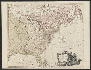
The United States of North America with the British & Spanish Territories according to the Treaty
Short Title
Map of Greater Plantation and Vicinity Florida
Short Title
Map of Greater Plantation and Vicinity Florida
Short Title
Watch Ruskin Grow, Chamber of Commerce
Short Title
Watch Ruskin Grow, Chamber of Commerce
Short Title
St. Petersburg, Fla. and Southern Pinellas County / Clearwater, Fla. and Northern Pinellas County
Short Title
St. Petersburg, Fla. and Southern Pinellas County / Clearwater, Fla. and Northern Pinellas County
Short Title
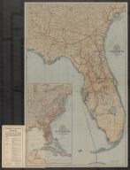
Preliminary Coast Chart No. 70 Florida Reefs, US Coast Survey
Short Title
Preliminary Coast Chart No. 70 Florida Reefs, US Coast Survey
Short Title
Florida Central & Peninsular R. R. Florida Trunk Line Information Folder November 1, 1896
Short Title
Florida Central & Peninsular R. R. Florida Trunk Line Information Folder November 1, 1896
Short Title
Americae Sive Novi Orbis Nova Descriptio
Short Title
Americae Sive Novi Orbis Nova Descriptio
Short Title
Sectional Map of the Eastern and Southern Portion of The State of Florida Showing The Lands Owned and Offered for Sale by the Following Railroad Companies:
Jacksonville, Tampa & Key West Railway.
Florida Southern Railway.
St. John & Lake Eustis Railway.
Sanford & Lake Eustis Railway.
Jacksonville, St. Augustine & Halifax River R'y.
St. Johns & Halifax River Railway.
St. Augustine & Halifax River Railway.
St. Johns Railway.
Short Title
A New-England Colony in the Highlands of Florida Belleview, Marion County
Short Title
A New-England Colony in the Highlands of Florida Belleview, Marion County
Short Title
Map of the Peninsula of Florida and Adjacent Islands
Author
Florida East Coast Railway
Short Title
Map of the Peninsula of Florida and Adjacent Islands
Author
Florida East Coast Railway
Short Title
Complete Map of Florida And The South with Index showing the Semi-Tropical Resorts Reached by the Lines of Atlantic Coast Line.
Short Title
Complete Map of Florida And The South with Index showing the Semi-Tropical Resorts Reached by the Lines of Atlantic Coast Line.
Short Title
Florida Central & Peninsular R. R. Florida Trunk Line Information Folder 1890
Short Title
Florida Central & Peninsular R. R. Florida Trunk Line Information Folder 1890
Short Title
Florida Central & Peninsular R. R. Florida Trunk Line Information Folder December 1, 1892
Short Title
Florida Central & Peninsular R. R. Florida Trunk Line Information Folder December 1, 1892
Short Title
Florida Central & Peninsular R. R. Florida Trunk Line Information Folder June 1895
Short Title
Florida Central & Peninsular R. R. Florida Trunk Line Information Folder June 1895
Short Title
Marion County Florida The Kingdom of the Sun A Map-Facts Study
Short Title
Marion County Florida The Kingdom of the Sun A Map-Facts Study
Short Title
Map of the Phosphate Fields of Florida
Author
Tucker, Captain James F.
Short Title
Map of the City of St. Augustine, Showing Location of Hotel San Marco
Short Title
Map of the City of St. Augustine, Showing Location of Hotel San Marco
Short Title
Miami Beach by Whitney Donati produced by Modern Graphics. Decorative, pictorial bird's eye view of Miami Beach, issued in Miami in 1990. The map gives a perspective of South Beach, which, though only 30 years old, is barely recognizable. The view highlights many hotels, cafes, tour companies, and other tourist hotspots, most of which no longer exist. A few paragraphs of descriptive text are set within a tropical cartouche in the lower right; they place the map within the historical context of the Miami revitalization campaign of the 1980s, which followed a declining period after the glamorous boom years of the 1940s-1960s. An inset map shows Miami Beach relative to the rest of Miami.
Short Title
Postcard-size advertisement for St. Petersburg-Bradenton Ferry with image of ferry on one side (ferry name is Pinellas) and map of greater Tampa Bay area on verso (with timetable)
Short Title
Postcard-size advertisement for St. Petersburg-Bradenton Ferry with image of ferry on one side (ferry name is Pinellas) and map of greater Tampa Bay area on verso (with timetable)
Short Title
Postcard advertising location of Dade City, Florida with discussion/description on one side and Tropical Trail map of peninsular Florida on the verso with an indicated location of Dade City
Short Title
Postcard advertising location of Dade City, Florida with discussion/description on one side and Tropical Trail map of peninsular Florida on the verso with an indicated location of Dade City
Short Title
Postcard-size advertisement for Bee Line Ferry by Florida State Improvement Commission. Image of ferry on one side (ferry name is Manatee) and map and timetable on verso
Short Title
Postcard-size advertisement for Bee Line Ferry by Florida State Improvement Commission. Image of ferry on one side (ferry name is Manatee) and map and timetable on verso
Short Title
Generalized Soil Map of Florida
Short Title
Invitation to the 31st Annual Tampa Bay Business Hall of Fame with colorful map on one side and photos of Legacy of Leaders recipients on the verso
|