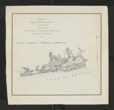
Detail View: Touchton Map Library: Sketch G, showing the progress in Section No. 7, U.S. Coast Survey in the year 1849.
|
Accession Number:
|
L2018.105.002
|
|
M Number:
|
M947
|
|
Short Title:
|
Sketch G, showing the progress in Section No. 7, U.S. Coast Survey in the year 1849.
|
|
Full Title:
|
Sketch G, showing the progress in Section No. 7, U.S. Coast Survey in the year 1849 : reconnoissance of Pensacola and Perdido Bays and plan of triangulation.
|
|
Year:
|
1849
|
|
Author:
|
U.S. Coast Survey
|
|
Object Publisher:
|
U.S. Coast Survey
|
|
Place of Publication:
|
Washington, D.C.
|
|
Obj Height cm:
|
18
|
|
Object Width cm:
|
19
|
|
Scale:
|
1:600,000
|
|
Continent:
|
North America
|
|
Country:
|
United States
|
|
State:
|
Florida
|
|
State:
|
Alabama
|
|
Geographic Area:
|
Pensacola Bay
|
|
Geographic Area:
|
Perdido Bay
|
|
County:
|
Escambia
|
|
County:
|
Santa Rosa
|
|
County:
|
Baldwin
|
|
Language:
|
English
|
|
Cartobibliographic notes:
|
Accession number L2018.105.001 is a similar map, but has brighter colors and lacks a border.
|
|
Subject Information:
|
Pensacola Bay (Fla.)
|
|
Subject Information:
|
Perdido Bay (Fla. and Ala.)
|
|
Related Item(s):
|
L2018.105.001
|
|
OCLC:
|
39206544
|