Detail View: Touchton Map Library: Florida state map
|
Accession Number:
|
L2018.105.053.001
|
|
M Number:
|
M1856a
|
|
Short Title:
|
Florida state map
|
|
Year:
|
1997
|
|
Author:
|
Highlights for Children, Inc.
|
|
Object Publisher:
|
Highlights for Children, Inc.
|
|
Place of Publication:
|
Columbus, Ohio
|
|
Obj Height cm:
|
61
|
|
Object Width cm:
|
48
|
|
Scale:
|
ca. 1:1,584,000
|
|
Continent:
|
North America
|
|
Country:
|
United States
|
|
State:
|
Florida
|
|
Language:
|
English
|
|
Verso:
|
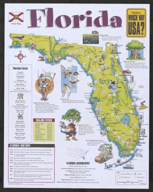
Text and color illustrations.
|
|
Type:
|
Pictorial map
|
|
Geographical Description:
|
Pictorial map showing highways, cities, and points of interest.
|
|
Cartobibliographic notes:
|
Includes location map, notes, chronology, table showing populations of major cities, and color illustrations.
Originally issued folded. Title comes from folded front panel.
Issued as part of the series: Highlights which way USA?
|
|
Subject Information:
|
Florida
|
|
OCLC:
|
1139709190
|