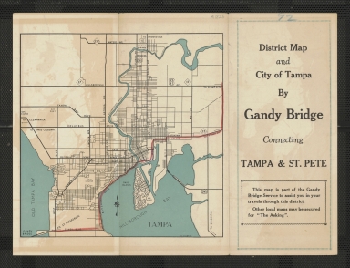
Detail View: Touchton Map Library: District map and city of Tampa by Gandy Bridge : connecting Tampa & St. Pete.
|
Accession Number:
|
L2018.111.073
|
|
M Number:
|
M1825
|
|
Short Title:
|
District map and city of Tampa by Gandy Bridge : connecting Tampa & St. Pete.
|
|
Year:
|
1939
|
|
Author:
|
Bowman Studios
|
|
Contributor(s):
|
W.C. Disbrow
|
|
Institution:
|
Gandy Bridge Co.
|
|
Object Publisher:
|
Bowman Studios
|
|
Place of Publication:
|
Tampa
|
|
Obj Height cm:
|
21
|
|
Object Width cm:
|
29
|
|
Scale:
|
no
|
|
Continent:
|
North America
|
|
Country:
|
United States
|
|
State:
|
Florida
|
|
City:
|
Tampa
|
|
Language:
|
English
|
|
Verso:
|
Street map of Tampa.
|
|
Geographical Description:
|
Larger map is road map of greater Tampa Bay Area and central Florida, copyright 1939 Bowman Studios, prepared for Gandy Bridge Co. Smaller map on verso is street map of Tampa, created by W.C. Disbrow.
|
|
Cartobibliographic notes:
|
"This map is part of the Gandy Bridge Service to assist you in your travels through this district. Other local maps may be secured for 'The Asking'"
|
|
Subject Information:
|
Roads
|
|
Subject Information:
|
Streets
|
|
Subject Information:
|
Gandy Bridge (Hillsborough County, Fla.)
|
|
Subject Information:
|
Florida
|
|
Subject Information:
|
Tampa (Fla.)
|
|
Related Item(s):
|
2019.058.015
|
|
Related Item(s):
|
1997.003.148
|
|
OCLC:
|
1117498113
|