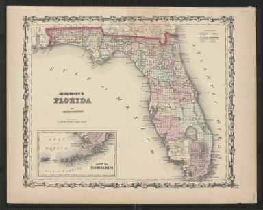
Detail View: Touchton Map Library: Johnson's Florida.
|
Accession Number:
|
L2019.068.076
|
|
M Number:
|
M148
|
|
Short Title:
|
Johnson's Florida.
|
|
Date Range:
|
1861-1862
|
|
Author:
|
Johnson & Browning
|
|
Object Publisher:
|
Johnson & Browning
|
|
Place of Publication:
|
New York
|
|
Obj Height cm:
|
29
|
|
Object Width cm:
|
36
|
|
Scale:
|
ca. 1:2,600,000
|
|
Continent:
|
North America
|
|
Country:
|
United States
|
|
State:
|
Florida
|
|
Language:
|
English
|
|
Insets:
|
Plan of the Florida Keys.
|
|
Geographical Description:
|
Shows counties, cities and towns, and railroads on a township grid.
|
|
Cartobibliographic notes:
|
This is a later state of an 1860-1861 map. In this map, the name of the Brunswick & Pensacola Railroad is shown just above the Florida state line as "Johnson &" with the rest of the name erased.
Publication date estimate is derived from information in "Ira Lourie's Johnson U.S. Map Project" web site.
In lower right outside map: "36."
|
|
Subject Information:
|
Florida
|
|
Subject Information:
|
Railroads
|
|
OCLC:
|
923794452
|