Detail View: Touchton Map Library: Greyhound's fun map of the sunshine zone.
|
Accession Number:
|
L2018.056.012
|
|
M Number:
|
M1206
|
|
Short Title:
|
Greyhound's fun map of the sunshine zone.
|
|
Year:
|
1936
|
|
Author:
|
Greyhound Lines
|
|
Object Publisher:
|
Greyhound Lines
|
|
Obj Height cm:
|
46
|
|
Object Width cm:
|
60
|
|
Scale:
|
no
|
|
Continent:
|
North America
|
|
Country:
|
United States
|
|
State:
|
Florida
|
|
Geographic Area:
|
Gulf Coast (U.S.)
|
|
Language:
|
English
|
|
Verso:
|
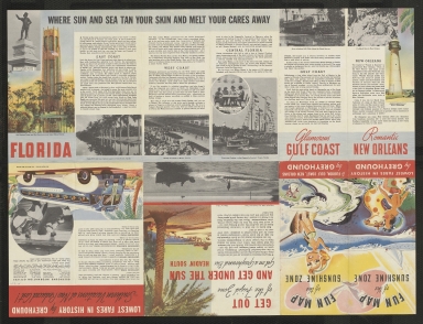
Text on locations in Florida and Gulf Coast.
|
|
Insets:
|
Map of Greyhound routes to Florida and Gulf Coast.
|
|
Type:
|
Pictorial map
|
|
Geographical Description:
|
Pictorial map of Florida and Gulf Coast. The cartoonish figures populating the map were intended to be humorous but the depictions of African Americans, American Indians, and Hispanics is offensive and derogatory. This was very common in publications during the 19th and 20th centuries, including those produced by large, nation-wide companies. Interstate buses, like those operated by Greyhound, required African American riders to move to the rear of the bus when state laws and/or customs required segregation by race.
|
|
Cartobibliographic notes:
|
Maps are one side of folded out pamphlet. Title on folded panel of pamphlet: Fun map of the sunshine zone.
Accession number L2018.105.045 appears to be a duplicate of this map.
|
|
Subject Information:
|
Bus lines
|
|
Subject Information:
|
This item was created during the era of Jim Crow. Its racist themes are not supported or condoned by the Tampa Bay History Center, which is an anti-racist institution. These items are important reminders of the racism and discrimination faced by African Americans, and other minorities, throughout the history of the United States.
|
|
Subject Information:
|
Florida; Gulf Coast (U.S.)
|
|
Related Item(s):
|
L2018.105.045
|
|
OCLC:
|
82384474
|