|
REFINE
Browse All : Images from 1960
1-21 of 21
Short Title
Indexed Street Map of Dade City, Florida by
Year
1960
Author
Fred J. Wysor, Jr.
Short Title
Indexed Street Map of Dade City, Florida by
Year
1960
Author
Fred J. Wysor, Jr.
Short Title
City of Tallahassee Inauguration of Governor Farris Bryant January 3, 1961.
Year
1960
Author
Jacobs
Short Title
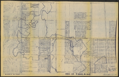
Location of Flood Waters, Temple Terrace (Sec. 13 - T28 S - R18E)
Year
1960
Short Title
Area Flooded By River, March 21, 1960, from 22nd St. to Hillsborough Avenue, Sec. 35, T 28 S, R 18 E
Year
1960
Short Title
Area Flooded By River, March 21, 1960, from 22nd St. to Hillsborough Avenue, Sec. 36, T 28 S, R 18 E
Year
1960
Short Title
Area Flooded By River, March 21, 1960, from 22nd St. to Hillsborough Avenue
Year
1960
Short Title
1960 "Section Map of Collier County, Florida" by Webb Realty Corporation of Miami. Shows township and range lines. Extensive markings by a previous owner.
Year
1960
Short Title
1960 "Section Map of Collier County, Florida" by Webb Realty Corporation of Miami. Shows township and range lines. Extensive markings by a previous owner.
Year
1960
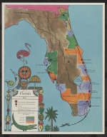
Short Title
Map of Florida from the January, 1960 issue of Fortune Magazine (verso of p. 119). Locates certain developments in Florida � including Progress Village in/near Tampa � and also indicates changes in population by county since 1950.
Year
1960
Short Title
Map of Florida from the January, 1960 issue of Fortune Magazine (verso of p. 119). Locates certain developments in Florida � including Progress Village in/near Tampa � and also indicates changes in population by county since 1950.
Year
1960
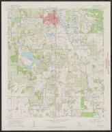
Short Title
Tampa, USGS, NG 17-14. Coverage area extends from Clearwater to south of Sanibel Island, including Sarasota, Bradenton, St. Petersburg, and the Temporary Explosives Anchorage south of Port Tampa.
Year
1960
Short Title
A Special Esso Map of Folklore and Legends of our Country with a Guide to the Treasuries of Americana Plus a Trip-Planning Road Map of the U.S.A.
Year
1960
Short Title
A Special Esso Map of Folklore and Legends of our Country with a Guide to the Treasuries of Americana Plus a Trip-Planning Road Map of the U.S.A.
Year
1960
Short Title
Rube Allyn's Authentic Fishing map Lower Tampa Bay #1A
Year
1960
Author
Rube Allyn
1-21 of 21
|