|
REFINE
Browse All : Images from 1969
1-13 of 13
Short Title
Florida's growth markets.
Year
1969
Author
Trend Publications.
Short Title
Florida Aeronautical Char
Year
1969
Author
H.M. Gousha
Short Title
Florida Aeronautical Char
Year
1969
Author
H.M. Gousha
Short Title
Vacation treasure map for Florida explorers
Year
1969
Author
Florida Power & Light Company
Short Title
Topographical map of the Tampa Quadrangle from 1969. The map was produced by the United States Department of the Interior Geological Survey and is of the Florida - Hillsborough Co. 7.5 Minute Series (Topographic). The map's subject is noted as Tampa, Fla. N22752.5 - W8222.5/7.5. Originally mapped, edited and published by the Geological Survey with control by the USGS [United States Geological Survey], the USC&GS [United States Coast and Geodetic Survey], and the USCE [United States Corps of Engineers]. The map is based off of aerial photographs from 1954, topographical surveys of 1956, and partially revised using aerial photographs taken in 1969. The red tinted areas on the map indicate "areas in which only landmark buildings are shown." Any areas or locations in purple are revisions based off of the 1969 aerial photographs.
Year
1969
Short Title
Topographical map of the St. Petersburg Quadrangle from 1969. The map was produced by the United States Department of the Interior Geological Survey and is of the Florida - Pinellas Co. 7.5 Minute Series (Topographic). The map's subject is noted as St.Petersburg, Fla. N2745 - W8237.2/7.5. Originally mapped, edited and published by the Geological Survey with control by the USGS [United States Geodetic Survey], the USC&GS [United States Coast and Geodetic Survey], and the Florida Geodetic Survey. The map is based off of aerial photographs from 1954, topographical surveys of 1956, hydrogaphic data from USC&GS charts 587 and 1257 (1953),and was partially revised using aerial photographs taken in 1969. The red tinted areas on the map indicate "areas in which only landmark buildings are shown." Any areas or locations in purple are revisions based off of 1969 aerial photographs which indicate the extension of urban areas. In the bottom right corner of the document there is a "Property of The Ohio State University Museum of Zoology" stamp but this has been crossed out in pen with the addition of "triplicate 14 Feb 83."
Year
1969
Short Title
Topographical map of the St. Petersburg Quadrangle from 1969. The map was produced by the United States Department of the Interior Geological Survey and is of the Florida - Pinellas Co. 7.5 Minute Series (Topographic). The map's subject is noted as St.Petersburg, Fla. N2745 - W8237.2/7.5. This map is an identical copy of record (2018.031.005). Originally mapped, edited and published by the Geological Survey with control by the USGS [United States Geodetic Survey], the USC&GS [United States Coast and Geodetic Survey], and the Florida Geodetic Survey. The map is based off of aerial photographs from 1954, topographical surveys of 1956, hydrogaphic data from USC&GS charts 587 and 1257 (1953),and was partially revised using aerial photographs taken in 1969. The red tinted areas on the map indicate "areas in which only landmark buildings are shown." Any areas or locations in purple are revisions based off of 1969 aerial photographs which indicate the extension of urban areas. In the bottom right corner of the document there is a "Property of The Ohio State University Museum of Zoology" stamp.
Year
1969
Short Title
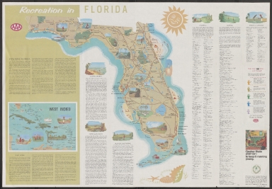
AAA American Automobile Association Florida and West Indies
Year
1969
Short Title
AAA American Automobile Association Florida and West Indies
Year
1969
Short Title
The handy illustrated encyclopedia of Florida.
Year
1969
Author
Jim Weakley
1-13 of 13
|


![Topographical map of the Tampa Quadrangle from 1969. The map was produced by the United States Department of the Interior Geological Survey and is of the Florida - Hillsborough Co. 7.5 Minute Series (Topographic). The map's subject is noted as Tampa, Fla. N22752.5 - W8222.5/7.5. Originally mapped, edited and published by the Geological Survey with control by the USGS [United States Geological Survey], the USC&GS [United States Coast and Geodetic Survey], and the USCE [United States Corps of Engineers]. The map is based off of aerial photographs from 1954, topographical surveys of 1956, and partially revised using aerial photographs taken in 1969. The red tinted areas on the map indicate "areas in which only landmark buildings are shown." Any areas or locations in purple are revisions based off of the 1969 aerial photographs.](https://luna.tampabayhistorycenter.org/MediaManager/srvr?mediafile=/Size1/TBHC~3~3/115/2018.031.001.jpg)
![Topographical map of the St. Petersburg Quadrangle from 1969. The map was produced by the United States Department of the Interior Geological Survey and is of the Florida - Pinellas Co. 7.5 Minute Series (Topographic). The map's subject is noted as St.Petersburg, Fla. N2745 - W8237.2/7.5. Originally mapped, edited and published by the Geological Survey with control by the USGS [United States Geodetic Survey], the USC&GS [United States Coast and Geodetic Survey], and the Florida Geodetic Survey. The map is based off of aerial photographs from 1954, topographical surveys of 1956, hydrogaphic data from USC&GS charts 587 and 1257 (1953),and was partially revised using aerial photographs taken in 1969. The red tinted areas on the map indicate "areas in which only landmark buildings are shown." Any areas or locations in purple are revisions based off of 1969 aerial photographs which indicate the extension of urban areas. In the bottom right corner of the document there is a "Property of The Ohio State University Museum of Zoology" stamp but this has been crossed out in pen with the addition of "triplicate 14 Feb 83."](https://luna.tampabayhistorycenter.org/MediaManager/srvr?mediafile=/Size1/TBHC~3~3/115/2018.031.005.jpg)
![Topographical map of the St. Petersburg Quadrangle from 1969. The map was produced by the United States Department of the Interior Geological Survey and is of the Florida - Pinellas Co. 7.5 Minute Series (Topographic). The map's subject is noted as St.Petersburg, Fla. N2745 - W8237.2/7.5. This map is an identical copy of record (2018.031.005). Originally mapped, edited and published by the Geological Survey with control by the USGS [United States Geodetic Survey], the USC&GS [United States Coast and Geodetic Survey], and the Florida Geodetic Survey. The map is based off of aerial photographs from 1954, topographical surveys of 1956, hydrogaphic data from USC&GS charts 587 and 1257 (1953),and was partially revised using aerial photographs taken in 1969. The red tinted areas on the map indicate "areas in which only landmark buildings are shown." Any areas or locations in purple are revisions based off of 1969 aerial photographs which indicate the extension of urban areas. In the bottom right corner of the document there is a "Property of The Ohio State University Museum of Zoology" stamp.](https://luna.tampabayhistorycenter.org/MediaManager/srvr?mediafile=/Size1/TBHC~3~3/115/2018.031.006.jpg)