|
Short Title
Historical Map of Florida showing points of interest to visitors
Year
1934
Author
issued by the Florida State Department of Agriculture
Short Title
Historical Map of Florida showing points of interest to visitors
Year
1934
Author
issued by the Florida State Department of Agriculture
Short Title
Map of Florida
Date Range
1881-1883
Author
Rand McNally & Co.
Short Title
Historical Map of Florida Historical Data Concerning Florida
Year
1932
Author
issued by the Florida State Department of Agriculture
Short Title
Gadsden Point
Year
1947
Date Range
1944,1947
Author
Army Map Service
Short Title
Anna Maria
Year
1946
Date Range
1944,1946
Author
Army Map Service
Short Title
Map of Pinellas County Florida Roads
Year
1937
Author
E. N. Metzen
Short Title
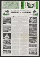
Fresh Water Fishing Guide of Leesburg, Florida and Vicinity
Date Range
c 1950s
Author
Finley C. Brooke
Short Title
Fresh Water Fishing Guide of Leesburg, Florida and Vicinity
Date Range
c 1950s
Author
Finley C. Brooke
Short Title
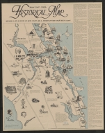
Historical Map Martin County, Florida
Year
1971
Author
[Ernest Lyons, Stuart Land Development, Inc.]
Short Title
El Portal Tampa's North Side Super Suburb
Year
1925
Author
Fernandez & Henderson Engineers
Short Title
El Portal Tampa's North Side Super Suburb
Year
1925
Author
Fernandez & Henderson Engineers
Short Title
Map of Lands Belonging to Florida Farms & Home, Inc., Located in Clay and Putnam Counties, Florida.
Year
1915
Author
Randall Wells
Short Title
Map of Lands Belonging to Florida Farms & Home, Inc., Located in Clay and Putnam Counties, Florida.
Year
1915
Author
Randall Wells
Short Title
Cote est de L'Amerique Septentrionale Floride. Riviere S te.Marie et Port de Fernandina
Year
1868
Date Range
1857
Author
Depot des Cartes et Plans de la Marine
Short Title
Tampa Bay
Year
1882
Date Range
1877-1879
Author
US Coast Survey
Short Title
Geologic and Topographic Map of Florida
Year
1909
Author
[United States Geological Survey, Florida State Geological Survey, E.H. Sellards]
Short Title
Citrus Park, Florida, Hillsborough County.
Year
1947
Author
Army Map Service
Short Title
General topographical map sheet XI : [peninsular Florida]
Date Range
1891?
Author
United States War Dept.
Short Title
Sinclair road map : Florida.
Year
1937
Author
Rand McNally and Company
Short Title
Sinclair road map : Florida.
Year
1937
Author
Rand McNally and Company
Short Title
Sullivan and Mendenhall's guide map of Tampa and vicinity, Hillsborough County, Florida.
Year
1939
Author
Fred D. Mendenhall
Short Title
Map of Florida showing the main line and branches of The International Railroad and Steamship Company of Florida.
Year
1884
Author
G. W. & C. B. Colton & Co.
Short Title
Map of the state of Florida.
Date Range
ca. 1874
Author
Taintor Bros. & Merrill
Short Title
Map of central portion of St. Petersburg, Florida.
Date Range
1930s
Author
St. Petersburg Map & Blueprint Co.
Short Title
Map of central portion of St. Petersburg, Florida.
Date Range
1930s
Author
St. Petersburg Map & Blueprint Co.
Short Title
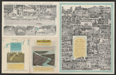
Map of Davis Islands : Tampa in the Bay.
Year
1925
Author
G. F. Young
Short Title
Davis Islands : Tampa In the Bay.
Year
1927
Author
G.F. Young
Short Title
Davis Islands : Tampa In the Bay.
Year
1927
Author
G.F. Young
Short Title
Map of the city of St. Petersburg, Florida and vicinity.
Date Range
1924-1929
Short Title
[Street map of Orlando, Florida]
Year
1928
Author
Florida Associated Engineers Inc.
Short Title
[Street map of Orlando, Florida]
Year
1928
Author
Florida Associated Engineers Inc.
Short Title
Historical map of Florida.
Year
1931
Author
Florida State Department of Agriculture
Short Title
Geologic map of Florida.
Year
1945
Author
C. Wythe Cooke
Short Title
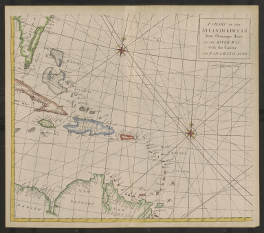
A Chart of the Atlantick Ocean from the Oronoque River to the River May, with the Caribee and Bahama Islands
Year
1728
Short Title
Plano del Rio De Sn. Juan desde su embocadura hasta Punta Dames (Florida).
Year
1887
Author
Spain. Direccion de Hidrografía
Short Title
East Florida, from surveys made since the last peace, adapted to Dr. Stork's history of that country.
Year
1769
Author
Thomas Jefferys
Short Title
Tourist's guide, Miami & Miami Beach, Florida.
Date Range
1925-1930?
Author
Richeson Love
Short Title
Tourist's guide, Miami & Miami Beach, Florida.
Date Range
1925-1930?
Author
Richeson Love
Short Title
Map of Florida.
Date Range
1910?
Author
George F. Cram
Short Title
Map of Lakeland
Year
1929
Date Range
1929-1933
Author
G.D. & H.D. Mendenhall
Short Title
Map of Lakeland
Year
1929
Date Range
1929-1933
Author
G.D. & H.D. Mendenhall
Short Title
Highway map & guide of Florida
Year
1933
Author
Mid-West Map Company
Short Title
Highway map & guide of Florida
Year
1933
Author
Mid-West Map Company
|


![General topographical map sheet XI : [peninsular Florida]](https://luna.tampabayhistorycenter.org/MediaManager/srvr?mediafile=/Size2/TBHC~3~3/24/M129.jpg)


![[Street map of Orlando, Florida]](https://luna.tampabayhistorycenter.org/MediaManager/srvr?mediafile=/Size2/TBHC~3~3/24/M836b.jpg)
![[Street map of Orlando, Florida]](https://luna.tampabayhistorycenter.org/MediaManager/srvr?mediafile=/Size1/TBHC~3~3/24/M836a.jpg)