|
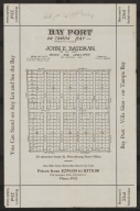
Short Title
Bay Port on Tampa Bay Subdivision
Year
1925
Author
John E. Bateman
Short Title
Untitled; eastern portion of a map of West Florida (with a small piece of East Florida)
Year
1803
Author
Andrew Ellicott
Short Title
Official road map, Florida.
Year
1959
Author
American Automobile Association
Short Title
Official road map, Florida.
Year
1959
Author
American Automobile Association
Short Title
U.S. No. 1 Highway, Canada to Florida
Year
1958
Author
U.S. No. 1 Highway Association
Short Title
U.S. No. 1 Highway, Canada to Florida
Year
1958
Author
U.S. No. 1 Highway Association
Short Title
Sunshine State Pkwy
Date Range
ca. 1957
Author
Florida State Turnpike Authority
Short Title
Sunshine State Pkwy
Date Range
ca. 1957
Author
Florida State Turnpike Authority
Short Title
Florida road condition map
Year
1926
Author
Florida State Road Department
Short Title
Florida
Date Range
1925-1926
Author
H.M. Gousha Company
Short Title
Florida
Date Range
1925-1926
Author
H.M. Gousha Company
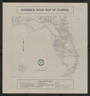
Short Title
Goodrich road map of Florida
Year
1916
Author
Raymond Beck
Short Title
Goodrich road map of Florida
Year
1916
Author
Raymond Beck
Short Title
Mileage map of the best roads of Florida
Date Range
1925-1926
Author
Clason Map Co.
Short Title
Mileage map of the best roads of Florida
Date Range
1925-1926
Author
Clason Map Co.
Short Title
Rinaldi's official road guide map of Florida
Year
1926
Author
Rinaldi Printing Co.
Short Title
Rinaldi's official road guide map of Florida
Year
1926
Author
Rinaldi Printing Co.
Short Title
This accurate road map is presented by the West Coast Association
Date Range
ca. 1920s
Author
Collins and Montanye
Short Title
This accurate road map is presented by the West Coast Association
Date Range
ca. 1920s
Author
Collins and Montanye
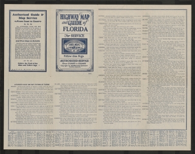
Short Title
Highway map & guide of Florida
Date Range
ca. 1932
Author
Mid-West Map Co.
Short Title
Highway map & guide of Florida
Date Range
ca. 1932
Author
Mid-West Map Co.
Short Title
Kaart van Louisiana, en Florida.
Year
1785
Author
Rigobert Bonne
Short Title
MWM Official Road Map Florida
Year
1936
Author
Mid-West Map Company
Short Title
MWM Official Road Map Florida
Year
1936
Author
Mid-West Map Company
Short Title
Langwith's motor trails map : Florida
Date Range
ca. 1925-1930
Author
Langwith, Inc.
Short Title
Langwith's motor trails map : Florida
Date Range
ca. 1925-1930
Author
Langwith, Inc.
Short Title
Highway map & guide of Florida
Date Range
1933-1934
Author
Mid-West Map Company.
Short Title
Highway map & guide of Florida
Date Range
1933-1934
Author
Mid-West Map Company.
Short Title
Highway map and guide of Florida
Date Range
ca. 1935-1939
Author
Mid-West Map Co.
Short Title
Highway map and guide of Florida
Date Range
ca. 1935-1939
Author
Mid-West Map Co.
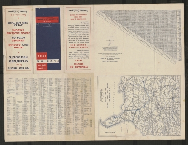
Short Title
Standard road map of Florida
Year
1932
Author
General Drafting
Short Title
Standard road map of Florida
Year
1932
Author
General Drafting
Short Title
Official road map of Florida
Year
1949
Author
State Road Department of Florida
Short Title
Official road map of Florida
Year
1949
Author
State Road Department of Florida
Short Title
Florida
Date Range
1930s
Author
Geographical Publishing Company
Short Title
Florida
Date Range
1930s
Author
Geographical Publishing Company
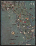
Short Title
untitled map of Florida from article Florida: Big Sunshine
Year
1946
Author
Arnold Blanch
Short Title
untitled map of Florida from article Florida: Big Sunshine
Year
1946
Author
Arnold Blanch
Short Title
Florida
Date Range
1940s
Author
Geographical Publishing Company
Short Title
Florida
Date Range
1940s
Author
Geographical Publishing Company
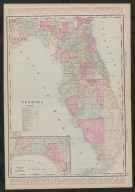
Short Title
Railroad and county map of Florida
Date Range
ca. 1891
Short Title
Railroad and county map of Florida
Date Range
ca. 1891
|