Who What Where WhenWHEREShow More |
Short Title
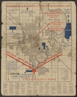
See Seminole Heights -- "The Last of the Best on South Florida Avenue"
Year
1925
Author
[G.D. Mendenhall, H.D. Mendenhall]
Short Title
See Seminole Heights -- "The Last of the Best on South Florida Avenue"
Year
1925
Author
[G.D. Mendenhall, H.D. Mendenhall]
Short Title
St. Vincents Island, Florida
Short Title
Rube Allyn's Authentic Fishing Map 1-G Hudson Aripeka Weekiwachee
Author
Erland M. Larson
Short Title
Rube Allyn's Authentic Fishing Map 1-G Hudson Aripeka Weekiwachee
Author
Erland M. Larson
Short Title
COVER ENVELOPE FOR Rube Allyn's Fishing Maps 1-G Hudson, Aripeka, New Port Richey, (Weekiwachee)
Short Title
COVER ENVELOPE FOR Rube Allyn's Fishing Maps 1-G Hudson, Aripeka, New Port Richey, (Weekiwachee)
Short Title
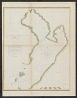
Reconnaissance of Tampa Bay Florida
Year
1855
Author
W. Fairfax
Short Title
COVER ENVELOPE FOR Rube Allyn's Fishing Maps 5-0 Lake Okeechobee
Short Title
COVER ENVELOPE FOR Rube Allyn's Fishing Maps 5-0 Lake Okeechobee
Short Title
COVER ENVELOPE FOR Rube Allyn's Fishing Maps 1-H Homosassa, Crystal River
Short Title
COVER ENVELOPE FOR Rube Allyn's Fishing Maps 1-H Homosassa, Crystal River
Short Title
Rube Allyn's Authentic Fishing Map Manatee & Braden Rivers #2D
Author
Alice Sheehan
Short Title
Rube Allyn's Authentic Fishing Map Manatee & Braden Rivers #2D
Author
Alice Sheehan
Short Title
Rube Allyn's Authentic Fishing Map Old Tampa Bay #1E
Author
Jack A. Meyer
Short Title
COVER ENVELOPE FOR Rube Allyn's Fishing Maps 1-E Old Tampa Bay
Short Title
Rube Allyn's Authentic Fishing Map Lake Panasoffkee #5A
Author
Alice Sheehan
Short Title
Rube Allyn's Authentic Fishing Map Lake Panasoffkee #5A
Author
Alice Sheehan
Short Title
COVER ENVELOPE FOR Rube Allyn's Fishing Maps 1-F Tarpon Springs, New Port Richey
Short Title
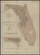
"Geologic and Topographic Map of Florida� from book about the Phosphate Deposits of Florida
Year
1915
Author
[G.C. Matson, F.G. Clapp, Samuel Sanford]
Short Title
COPY of a chart of waters between Venice, FL and Punta Gorda, FL. Sold at Plamore Resort at Venice � and chart shows the Resort�s location.
Short Title
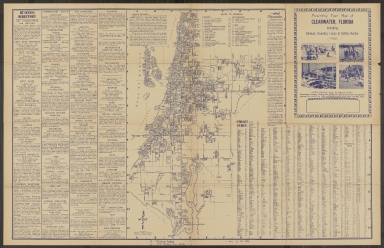
Presenting Your Map of Clearwater, Florida including Belleair, Dunedin, Largo & Safety Harbor
Short Title
Per dealer this original cigarette card was from the 1888 set of cards called State and Territorial Governors, Coats of Arms, etc. � N133, issued in the U. S. by W. Duke & Sons Ltd. The Florida Governor illustrated is Governor Perry. A map of Florida is
Year
1888
Short Title
Per dealer this original cigarette card was from the 1888 set of cards called State and Territorial Governors, Coats of Arms, etc. � N133, issued in the U. S. by W. Duke & Sons Ltd. The Florida Governor illustrated is Governor Perry. A map of Florida is
Year
1888
Short Title
The Rand-McNally new commercial atlas map of Florida.
Year
1914
Author
Rand, McNally and Company
Short Title
The Rand-McNally new commercial atlas map of Florida.
Year
1914
Author
Rand, McNally and Company
Short Title
Carta Particolare della Baia di Messico con la Costa
Year
1646
Date Range
1646-1647
Author
Robert Dudley
Short Title
Sunshine Skyway St. Petersburg to Bradenton U. S. Route 19 over Lower Tampa Bay
Date Range
post-1954
Short Title
Sunshine Skyway St. Petersburg to Bradenton U. S. Route 19 over Lower Tampa Bay
Date Range
post-1954
Short Title
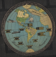
circular Chart of Knowledge by S. G. Bocholtz, Boston (Chart of Knowledge Co. of America). One side of this volvelle (i.e., a �wheel chart� of paper construction with movable parts) is a map of the western hemisphere plus part of Africa and Europe � with
Year
1931
Short Title
circular Chart of Knowledge by S. G. Bocholtz, Boston (Chart of Knowledge Co. of America). One side of this volvelle (i.e., a �wheel chart� of paper construction with movable parts) is a map of the western hemisphere plus part of Africa and Europe � with
Year
1931
Short Title
circular Chart of Knowledge by S. G. Bocholtz, Boston (Chart of Knowledge Co. of America). The second side of this volvelle (a �wheel chart� of paper construction with movable parts) is a map of the United States (with each state named) plus Canada, Mexi
Year
1932
Short Title
circular Chart of Knowledge by S. G. Bocholtz, Boston (Chart of Knowledge Co. of America). The second side of this volvelle (a �wheel chart� of paper construction with movable parts) is a map of the United States (with each state named) plus Canada, Mexi
Year
1932
Short Title
Manuscript map of Lake Weir Florida
Date Range
ca. 1885
Short Title
Map of Dade County Florida 1926 This is a 1926 Associated Map Company map of Dade County, Florida. The map depicts the region from Monroe County and Collier County to the Atlantic Ocean and from Broward County to Monroe County and Florida Bay. Highly detailed, the entire county is divided into townships with every section in each township numbered. Miami is situated in the upper right corner, with numerous streets illustrated and labeled, along with Miami Beach and Key Biscayne. The Okeechobee Road and the Miami Canal are also labeled, as are the Royal Glades Canal and the Miami Trail and Canal. Towns south of Miami along the coast are also identified, including Homestead, Modello, and Florida City. Landmarks along the coast, such as keys, bays, sounds, and beaches are noted. This map was created and published by the Associated Map Company in 1926. The Associated Map Company (fl. c. 1926 - 1928) was a map publishing firm based in Miami, Florida active during the early 20th century.
Year
1926
Short Title
Military Map of Florida South of Tampa Bay
Year
1856
Short Title
Map lands colored blue indicate the territory in which the following companies own land Florida land and Improvement Company Okeechobee Land Co. Kissimmee Land Co. F. Bourquin Litho. Removed from: Florida The Disston Lands.
Year
1885
Author
Florida Land and Improvement Company. Atlantic and Gulf Coast Canal and Okeechobee Land Company
Short Title
Map of the Peninsula of Florida and Adjacent Islands
Year
1912
Author
Land Dept. of the Florida East Coast Railway
Short Title
Granville's Railroad and Township Map of Florida
Year
1886
Author
Charles Granville
Short Title
Granville's Railroad and Township Map of Florida
Year
1886
Author
Charles Granville
Short Title
Fulton's Guide Map of Tampa Fla W. Tampa Features & Suburbs. Map of the City of Tampa and surrounding area produced by Rinaldi Printing Company and distributed by Florida News Company. Map shows downtown Tampa, Tampa Heights, Hyde Park and surrounding neighborhoods. Formerly contained in booket.
Year
1924
Short Title
Booklet formerly containing Fulton's Guide Map of Tampa Fla W. Tampa Features & Suburbs. Back cover highlights places of interest including Ballast Point Park, City Park-Municipal Playground, Desoto Park, and Sulphur Springs.
Year
1924
Short Title
Atlantic Coast Line Railroad - map of the eastern United States (1938)
Year
1938
Short Title
Map to Illustrate the conquest of Florida
Year
1851
Author
J.H. Colton
Short Title
1936 Colotext Pictorial Story Map of the West Indies. The Story Map of the West Indies This is a 1936 Colortext pictorial story map of the West Indies. The map depicts the region from the Gulf of Mexico and the Yucatan Peninsula to the Leeward Islands and Georgetown, Guyana and from New York and Chicago to northern South America. Highly detailed, each island is labeled, along with myriad locations including cities and towns, such as Havana, Port-au-Prince, and San Juan. Flags are used in the Leeward Islands to identify which European country claimed ownership of each island. The British Union Jack is also illustrated next to Bermuda and the Bahamas. Numerous vignettes populate the map, including native birds, animals, and fish, pirates and pirate ships, and locals dressed in indigenous costumes. Historical events are also chronicled, such as Ponce de Leon's first settlement on Puerto Rico and the naval battle of Santiago. Cities in the United States are also noted, including New York City (illustrated by its famous skyline), Washington, D.C. (marked by the U.S. Capitol), Detroit, Chicago, and Miami. The whole is surrounded by a decorative border that employs a motif derived from indigenous tropical fruits and native West Indian handicraft. Publication History and Census This map was published by Colortext Publications, Inc. in 1936. It is part of five different institutional collections and is rare on the market. CARTOGRAPHER Colortext Publications (c. 1933 � 1950) was a Chicago based firm active in the middle part of the 20th century. The firm's earliest work is a series of pamphlets associated with the Chicago Century of Progress International Exposition (1933-1934). Following the exposition Colortext partnered with various artist to create a series of pictorial maps known as 'Story Maps.' The firm partnered with such notable pictorial map artists as Ernest Dudley Chase, Egbert G. Jacobson, Julio de Diego, A. Walker and W.E. Vogelear. Although it is unclear who founded the firm, it is registered business at 8 South Michigan Avenue, Chicago, as early as 1933. In 1938 and 1940, the firm produced to exceptional publications, a panoramic view of Chicago and the Military Panoramap of the Theatre of War. These depart markedly form the 'Story Map' model and reveal a greater level of sophistication than evident in Colortext's earlier publications. Sometime after World War II Colortext was acquired by the Chicago businessman and druggist Paul J. Mandalbach. The firm's last publication was in 1950, a Story Map of the West Indies. OCLC 872330844.
Year
1936
Short Title
Your Guide to South Beach Two-part, color-printed view of South Beach, by Albert. The view presents a lively picture of life along Ocean Drive and on Miami Beach in the early 1990s. Even fairly recent views of South Beach are hard to come, as their separately-issued nature made them ephemeral.
Year
1994
|