WHERE
-
[Map of southern Florida
…
(1)
-
[Pensacola and Mobile are
…
(2)
-
[Pensacola-Mobile area]
(4)
-
[Pensacola-Mobile area].
(2)
-
[Pensacola-Mobile region]
(4)
-
[Pensacola-Mobile region]
…
(2)
-
A Draught of Spirito Sanc
…
(2)
-
A Plan of Pensacola Harbo
…
(1)
-
A Plan of Pensacola Harbo
…
(1)
-
Abaco Island
(1)
-
Africa
(3)
-
Alabama
(29)
-
Alachua
(7)
-
Alachua; Hillsborough
(2)
-
Altamonte Springs
(1)
-
Amelia Island
(2)
-
Anclote Keys
(1)
-
Anna Maria
(1)
-
Apalachicola
(4)
-
Apalachicola River
(1)
-
Apalachicola River area
(2)
-
Aripeka
(2)
-
Arkansas
(1)
-
Asia
(3)
-
At left top inset-Florida
…
(1)
-
Atlantic Coast
(2)
-
Atlantic Coast (Fla.)
(3)
-
Atlantic Coast (U.S.)
(9)
-
Atlantic Intracoastal Wat
…
(1)
-
Atlantic Ocean
(2)
-
Atlantic Ocean; Caribbean
(1)
-
Atlantic Ocean; Gulf of M
…
(1)
-
Atlantic States
(4)
-
Avon Park
(1)
-
Azores
(1)
-
Bahama Islands
(1)
-
Bahamas
(30)
-
Bahia de Matanças int Gr
…
(1)
-
Bahia Honda
(1)
-
Baja Honda int Groodt.
(1)
-
Baker
(2)
-
Baldwin
(2)
-
Banana River
(1)
-
Bar & Entrance of Mobile
…
(1)
-
Bar & Entrance of Pensaco
…
(1)
-
Battle ground of Major Da
…
(2)
-
Battle ground of Major Da
…
(1)
-
Battle ground of Major Da
…
(1)
-
Bay
(2)
-
Bermuda Islands
(1)
-
Big Cypress
(1)
-
Big Pine Key
(2)
-
Black and white map showi
…
(1)
-
Black Hammock Island
(1)
-
Boca Grande
(1)
-
Boca Raton
(3)
-
Border States
(2)
-
Bottom inset: Tampa Bay S
…
(1)
-
bottom portion of Florida
(1)
-
bottom portion of Texas
(1)
-
Braden River
(2)
-
Bradenton
(3)
-
Bradford
(1)
-
Brandon
(2)
-
Brandon Area
(2)
-
Brazil; Cuba; Jamaica; Ba
…
(2)
-
Brevard
(4)
-
Brighton
(1)
-
British East and West Flo
…
(1)
-
British East Florida
(1)
-
Broward
(8)
-
Broward County
(2)
-
Caloosahatchee River
(1)
-
Camp Blanding
(2)
-
Canada
(6)
-
Canal de Bahama
(1)
-
Cape Canaveral
(1)
-
Cape Sable
(1)
-
Caribbean
(2)
-
Caribbean Area
(9)
-
Caribbean; Gulf of Mexico
…
(1)
-
Caroline
(1)
-
Carrabelle
(1)
-
Carte des embouchures du
…
(1)
-
Casey Key
(2)
-
Casselberry
(1)
-
Cedar Key
(1)
-
Cedar Keys
(1)
-
Central America
(6)
-
Central Florida
(2)
-
Central St. Petersburg.
(2)
-
Central Tampa.
(2)
-
Charleston and vicinity
(3)
-
Charleston Harbor
(1)
-
Charlotte
(4)
-
Charlotte Harbor (Bay)
(1)
-
Charlotte Harbor; Sanibel
…
(1)
-
Chart of the currents in
…
(1)
-
Chart of the Eads Jetty S
…
(1)
-
Chart of the mouths of th
…
(3)
-
Chuluota
(1)
-
Citrus
(1)
-
City
(1)
-
City of Temple Terrace.
(4)
-
Civic Center Area
(2)
-
Clay
(3)
-
Clay County
(1)
-
Clearwater
(6)
-
Clermont
(1)
-
Coffin's Patches
(1)
-
Collier
(2)
-
Collier County
(1)
-
Colombia
(1)
-
Color illustration, "Capt
…
(1)
-
Color illustration, "Capt
…
(1)
-
Color illustration, "Exto
…
(1)
-
Color illustration, "The
…
(1)
-
Color illustration, "Then
…
(1)
-
Color illustration, Buffi
…
(1)
-
Color illustration, Judso
…
(1)
-
Color illustration, pirat
…
(1)
-
Color illustration, Sammi
…
(1)
-
Color illustration, two s
…
(1)
-
Color illustration,"Who s
…
(1)
-
Columbia
(2)
-
Comparative elevation of
…
(1)
-
Continuation of Florida
(7)
-
Continuation of Florida.
(3)
-
Continuation of northwest
…
(1)
-
Continuation of Pass-a-Gr
…
(1)
-
Continuation of the Coast
…
(1)
-
Continuation of western F
…
(2)
-
Coral Gables
(3)
-
Costa Rica
(1)
-
Cotee Lake
(1)
-
County Map of North Carol
…
(1)
-
Cross Florida Barge Canal
(2)
-
Crystal River
(1)
-
Cuba
(50)
-
Cuba.
(2)
-
Cuba; Dominican Republic;
…
(1)
-
Cumberland lsland
(1)
-
Cumberland Sound
(2)
-
Dade Battlefield
(1)
-
Dade Battlefield Historic
…
(2)
-
Dade City
(2)
-
Dade County
(2)
-
Dade; Miami Dade
(1)
-
Daytona Beach Shores
(1)
-
Daytona Beach
(7)
-
De Land
(3)
-
De Soto
(10)
-
Deerfield Beach
(2)
-
Del Ray Beach
(1)
-
DeLand
(1)
-
Delray Beach
(2)
-
Der Niagara-Fall und sein
…
(1)
-
Der südliche Teil von Fl
…
(1)
-
Der südliche Teil von Te
…
(1)
-
Distances to Miami
(4)
-
Distances to Miami.
(4)
-
Dixie Highway
(2)
-
Dominican Republic
(2)
-
Downtown Tampa
(8)
-
downtown Tampa
(1)
-
Downtown Tampa.
(22)
-
Dry Tortugas
(36)
-
Dry Tortugas.
(37)
-
Du Noveau Mexique
(1)
-
Dunedin
(2)
-
Duval
(11)
-
Dètroit de la Floride
(1)
-
East (U.S)
(1)
-
East (U.S.)
(1)
-
East Coast of Florida; Ev
…
(2)
-
East Florida
(3)
-
East Florida; West Florid
…
(1)
-
East Tampa
(1)
-
Eastern Entrance to St. G
…
(1)
-
Eastern entrance to St. R
…
(1)
-
Eastern Hemisphere
(1)
-
Eastern portion of the Un
…
(1)
-
Eastern portion of the Un
…
(2)
-
Eastern U.S.
(1)
-
Eastern United States
(2)
-
Eastern United States; At
…
(1)
-
eight regional insets
(2)
-
England
(1)
-
Englewood
(1)
-
Enlarged map of the Tampa
…
(2)
-
Enlarged map of the Tampa
…
(2)
-
Enlarged plan of Pensacol
…
(1)
-
Entrance to Appalachicola
…
(1)
-
Entrance to Mobile Bay Lt
…
(1)
-
Entrance to Ocklockony Ba
…
(1)
-
Entrance to Pensacola Bay
…
(1)
-
Entrance to St. Augustine
…
(1)
-
Entrance to St. John's Ri
…
(1)
-
Entrance to St. Joseph's
…
(1)
-
Entrance to St. Mary's Ha
…
(1)
-
Entrances to St. Andrew's
…
(1)
-
Escambia
(15)
-
Escambia; Monroe
(1)
-
Europe
(6)
-
Europe; Asia; Africa
(3)
-
Evan's Polymetric Table o
…
(1)
-
Everglades
(3)
-
Everglades and Key West
(1)
-
Everglades National Park
(1)
-
Extension of the larger m
…
(1)
-
Fanning Island
(1)
-
Fern Park
(1)
-
Fernandina
(1)
-
Fernandina Beach
(1)
-
Fernandina; Amelia Island
(1)
-
Five road maps showing ho
…
(2)
-
Florida
(1279)
-
Florida (Western section)
(2)
-
Florida and the east coas
…
(2)
-
Florida City
(1)
-
Florida East Coast
(1)
-
Florida Keys
(22)
-
Florida Keys.
(11)
-
Florida Ocidental
(1)
-
Florida Oriental
(1)
-
Florida Panhandle
(9)
-
Florida panhandle
(2)
-
Florida Panhandle; Florid
…
(1)
-
Florida Panhandle; northe
…
(1)
-
Florida Panhandle; northe
…
(1)
-
Florida peninsula
(1)
-
Florida Straits
(1)
-
Florida Territory
(5)
-
Florida West Coast
(2)
-
Florida | Georgia
(2)
-
Florida, Straits of
(1)
-
Florida-Georgia border
(1)
-
Florida; East Florida; We
…
(1)
-
Florida; Georgia
(1)
-
Florida; Georgia; Alabama
(1)
-
Florida; Georgia; Alabama
…
(1)
-
Florida; Georgia; Alabama
…
(2)
-
Florida; Georgia; Alabama
…
(1)
-
Florida; Georgia; South C
…
(3)
-
Florida; Georgia; South C
…
(1)
-
Florida; Georgia; South C
…
(1)
-
Florida; Georgia; South C
…
(1)
-
Floride Occidentale
(1)
-
Floride Orientale
(1)
-
Forest City
(1)
-
Forest Hills - Babe Zahar
…
(2)
-
Forme des balises.
(1)
-
Fort Dallas Park
(2)
-
Fort Lauderdale
(3)
-
Fort Myers
(2)
-
Fort Pierce
(1)
-
Four inset maps show the
…
(1)
-
Franklin
(9)
-
Gadsden
(2)
-
Gandy Bridge
(6)
-
Gateway to Pan America
(2)
-
General map of part of Fl
…
(1)
-
General Map of Part of Fl
…
(1)
-
Geneva
(1)
-
Georgia
(37)
-
Georgia; Florida
(1)
-
Georgia; Florida; Louisia
…
(1)
-
Georgie
(1)
-
Glades
(1)
-
Goldenrod
(1)
-
Green Cove Springs
(1)
-
Greenland
(1)
-
Grove City
(1)
-
Guatemala
(1)
-
Gulf Coast
(1)
-
Gulf Coast (Fla.)
(12)
-
Gulf Coast (Mexico)
(8)
-
Gulf Coast (U.S.)
(19)
-
Gulf of Mexico
(7)
-
Gulf of Mexico; Caribbean
…
(2)
-
Gulf of Mexico; Mexico Ci
…
(1)
-
Gulf States
(4)
-
Gulf Stream
(1)
-
Gulfport
(3)
-
Haines City
(2)
-
Haiti
(2)
-
Halifax River
(2)
-
Harbour of St. Augustine
(5)
-
Harbour of St. Augustine.
(1)
-
Hardee
(2)
-
Havana int Groodt.
(1)
-
Hernando
(3)
-
Highlands
(8)
-
Hilliard
(1)
-
Hillsboro River Drainage
…
(1)
-
Hillsborough
(170)
-
Hillsborough Bay
(3)
-
Hillsborough County
(12)
-
Hillsborough River
(1)
-
Hillsborough; Pinellas
(1)
-
Hilsboro Bay
(1)
-
Hispaniola
(2)
-
Hispanola
(1)
-
Hollywood
(2)
-
Holmes Beach
(1)
-
Holy Hill
(1)
-
Homestead
(2)
-
Homosassa
(1)
-
Honduras
(1)
-
Hours to St. Petersburg f
…
(2)
-
Hudson
(3)
-
Hudson Creek
(1)
-
Ile Ameila
(1)
-
Ile Cumberland
(1)
-
Ile Tiger
(1)
-
Index to Adjoining Sheets
(1)
-
Index to Boundaries
(1)
-
Indian River
(5)
-
Indian River (Lagoon)
(5)
-
Indian River County
(5)
-
Indian Rocks Beach
(2)
-
inset at the lower left c
…
(2)
-
Inset Chart of Key West b
…
(2)
-
Inset maps feature Key We
…
(1)
-
Inset of western Panhandl
…
(1)
-
Inset shows map of Florid
…
(1)
-
Isla de Cuba
(2)
-
Isla de Santo Domingo
(2)
-
Isla Jamayca
(2)
-
Islamorada
(1)
-
Island of New Found Land
(1)
-
Islas Lucayas o de Bahama
(2)
-
Isthmus of Tehuantepec
(1)
-
Jackson
(2)
-
Jacksonville
(20)
-
Jacksonville and Vicinity
(4)
-
Jacksonville and vicinity
(2)
-
Jacksonville to Saint Aug
…
(1)
-
Jacksonville-St. Augustin
…
(3)
-
Jacksonville; Palatka; Ma
…
(1)
-
Jamaica
(10)
-
Jefferson
(1)
-
Jessamine
(1)
-
Jucatan
(1)
-
Jupiter Island
(1)
-
Kennedy Space Center
(2)
-
Kentucky
(4)
-
Key West
(16)
-
Key West as Surveyed Febr
…
(1)
-
Kissimmee
(1)
-
Kissimmee River
(1)
-
Lafayette
(2)
-
Lake
(3)
-
Lake City
(1)
-
Lake County
(4)
-
Lake Mary
(1)
-
Lake Okeechobee
(1)
-
Lake Panasoffkee
(2)
-
Lake Superior
(1)
-
Lake Wales
(3)
-
Lake Worth
(1)
-
Lakeland
(16)
-
Lanark
(2)
-
Largo
(2)
-
Laurel
(1)
-
Lee
(2)
-
Lee County
(3)
-
Leesburg
(2)
-
Lemon Bay
(1)
-
Leo
(1)
-
Leon
(4)
-
Leroy
(9)
-
Les Bermudes
(1)
-
Les costes de la Louisian
…
(1)
-
Levy
(4)
-
Location map : from U.S.C
…
(3)
-
Location map showing Pine
…
(1)
-
Location map, map of Flor
…
(2)
-
Longwood
(1)
-
Looking South from Post O
…
(1)
-
Louisiana
(16)
-
Louisiane
(1)
-
lower peninsula of Florid
…
(1)
-
Lynn Haven
(2)
-
Main Entrance to St. Geor
…
(1)
-
Main entrance to St. Geor
…
(1)
-
Main highways in eastern
…
(1)
-
Maine
(2)
-
Manatee
(16)
-
Manatee River
(4)
-
Map of Florida and the We
…
(9)
-
Map of Florida Panhandle
…
(1)
-
Map of Florida Panhandle.
(2)
-
Map of Florida with steam
…
(1)
-
Map of Greyhound routes t
…
(4)
-
Map of Lee County, Florid
…
(2)
-
Map of North America sout
…
(2)
-
Map of northwest Florida.
(4)
-
Map of northwestern Flori
…
(4)
-
Map of peninsular Florida
…
(1)
-
Map of routes through Geo
…
(2)
-
Map of South Carolina
(1)
-
Map of South Carolina wit
…
(1)
-
Map of southern Florida.
(1)
-
Map of Tampa area (100 mi
…
(4)
-
Map of the Florida Keys a
…
(1)
-
Map showing Georgia, Flor
…
(1)
-
Map showing lines of tran
…
(2)
-
Map showing part of Lake,
…
(1)
-
Map showing part of Lake,
…
(6)
-
Map showing parts of Lake
…
(8)
-
Map showing parts of Lake
…
(2)
-
Map Showing Parts of Lake
…
(1)
-
Map showing parts of Lake
…
(4)
-
Map showing parts of Lake
…
(4)
-
Map showing parts of Lake
…
(2)
-
Map showing parts of Lake
…
(1)
-
Map showing parts of Lake
…
(1)
-
Map showing parts of Lake
…
(2)
-
Map showing parts of Lake
…
(1)
-
Map Showing the Relation
…
(1)
-
Maps Showing the Florida
…
(1)
-
Marianna
(1)
-
Marion
(20)
-
Martin
(2)
-
Merritt Island
(2)
-
Mexico
(20)
-
Mexico, Gulf of
(2)
-
Miami
(32)
-
Miami and Miami Beach
(4)
-
Miami and Vicinity
(4)
-
Miami and vicinity
(4)
-
Miami Beach
(28)
-
Miami Metropolitan Area
(2)
-
Miami-Dade
(29)
-
Miami-Dade County
(2)
-
Miami; Miami Beach
(1)
-
Middle Atlantic States
(3)
-
Middle entrance to St. Ge
…
(1)
-
Middle inset-Old Hillsbor
…
(1)
-
Middle West
(1)
-
Mississippi
(8)
-
Mississippi River
(1)
-
Missouri
(1)
-
Mobile
(9)
-
Mobile.
(5)
-
Monroe
(18)
-
Monroe County
(1)
-
Mosquito Lagoon
(1)
-
Mouths of the Suwanee Riv
…
(1)
-
Mullet Key and vicinity.
(2)
-
Murdock
(1)
-
Myakka City
(1)
-
Myakka River
(1)
-
Nassau
(8)
-
Nassau County
(2)
-
Nassau River
(2)
-
National trails east of t
…
(2)
-
New England
(1)
-
New Mexico
(1)
-
New Port Comfort
(1)
-
New Port Richey
(1)
-
New Providence
(1)
-
New Smyrna
(1)
-
New York
(1)
-
Nicaragua
(1)
-
Nokomis
(1)
-
None
(2)
-
North America
(1370)
-
North America (Caribbean
…
(1)
-
North America; Atlantic O
…
(1)
-
North America; Central Am
…
(1)
-
North America; Europe (sm
…
(1)
-
North America; South Amer
…
(4)
-
North America; South Amer
…
(2)
-
North American continent
…
(1)
-
North Carolina
(13)
-
North Florida
(1)
-
North Orlando
(1)
-
North Palm Beach
(1)
-
North western part of Flo
…
(1)
-
North Western Portion of
…
(1)
-
North western portion of
…
(1)
-
North-western part of Flo
…
(1)
-
North-western portion of
…
(19)
-
North-Western portion of
…
(13)
-
North-Western Portion of
…
(1)
-
North-western portion of
…
(32)
-
northeast Florida
(2)
-
Northeast Florida
(1)
-
northeast Florida; Britis
…
(1)
-
northeast Florida; Britis
…
(1)
-
Northeast Florida; Territ
…
(1)
-
Northern Gulf Coast; Gulf
…
(1)
-
Northwest Florida
(4)
-
Northwest Passage
(1)
-
Northwestern portion of
…
(2)
-
Northwestern Florida
(6)
-
Northwestern Florida.
(2)
-
Northwestern Part of Flor
…
(4)
-
Northwestern part of Flor
…
(3)
-
Northwestern part of Flor
…
(2)
-
Northwestern part of stat
…
(4)
-
Northwestern portion of
…
(13)
-
Northwestern portion of
…
(34)
-
Nouveau Royaume de Leon
(1)
-
Nova Scotia
(1)
-
Ocala
(1)
-
Ochlockonee River; Ochloc
…
(1)
-
Old Spanish Trail
(1)
-
Old Tampa Bay
(2)
-
Olustee; Ocean Pond; nort
…
(1)
-
Orange
(10)
-
Orange Park
(1)
-
Orlando
(9)
-
Ormond Beach
(3)
-
Osceola
(2)
-
Osprey
(1)
-
Oviedo
(1)
-
Palatka
(1)
-
Palm Beach
(9)
-
Palm Harbor
(1)
-
Palmetto
(1)
-
Panama
(3)
-
Panama City
(3)
-
Panhandle of Florida
(1)
-
Parte de la Ysla de Cuba
(1)
-
Pasco
(9)
-
Patrick Air Force Base
(2)
-
Peace River Valley
(1)
-
Pennsylvania
(3)
-
Pensacola
(27)
-
Pensacola Bay
(10)
-
Pensacola Bay Area
(1)
-
Pensacola Bay; Santa Rosa
…
(1)
-
Pensacola-Mobile area
(2)
-
Pensacola-Mobile region
(2)
-
Pensacola-Mobile region.
(6)
-
Pensacola.
(1)
-
Pensacola; Key West
(1)
-
Perdido Bay
(2)
-
Perrine
(1)
-
Pictorial representations
…
(1)
-
Pinellas
(54)
-
Pinellas County
(6)
-
Pinellas Park
(2)
-
Pinellas; Hillsborough; M
…
(1)
-
Placida
(1)
-
Plains States
(1)
-
Plamore
(1)
-
Plan for a new settlement
…
(1)
-
Plan of Charlestown
(1)
-
Plan of government survey
(2)
-
Plan of Grounds and Impro
…
(1)
-
Plan of Pensacola
(2)
-
Plan of St. Augustine
(1)
-
Plan of Tallahassee
(1)
-
Plan of the City of Talla
…
(1)
-
Plan of the Florida Keys
(6)
-
Plan of the Florida Keys
…
(15)
-
Plano de la Aguadilla
(2)
-
Plano del Baxo
(2)
-
Plant City
(1)
-
Polk
(23)
-
Ponce de Leon Inlet
(1)
-
Population of Incorporate
…
(2)
-
Port de Fernandina
(1)
-
Port Everglades
(1)
-
Port of Tampa; Tampa Bay;
…
(2)
-
Port Tampa
(6)
-
Port Tampa City
(1)
-
portion of Florida (Escam
…
(1)
-
portion of Mexico shown w
…
(1)
-
portion of western tip of
…
(1)
-
Principal Highways of Flo
…
(2)
-
Principal products and pr
…
(3)
-
Profile along the sailing
…
(1)
-
Profile along the sailing
…
(1)
-
Profile on line of propos
…
(1)
-
Province of Quebec
(1)
-
Provincia de Yucatan
(1)
-
Punta Gorda
(2)
-
Putnam
(2)
-
Quebec
(1)
-
Ravine State Gardens
(1)
-
Redington Beach
(2)
-
Redland District
(1)
-
Republic of Cuba
(2)
-
Ridgewood
(1)
-
Road map of Florida: From
…
(2)
-
Safety Harbor
(4)
-
Saint Augustine
(1)
-
Saint Johns
(2)
-
Saint Johns River
(14)
-
Saint Marys River
(3)
-
Saint Petersburg
(2)
-
Saint Petersburg Beach
(2)
-
Saint Sebastian River
(5)
-
Saint Vincent Island
(1)
-
Sanford
(1)
-
Sanibel
(1)
-
Sanlando Springs
(1)
-
Santa Rosa
(2)
-
Santa Rosa Island
(1)
-
Sarasota
(13)
-
Sarasota Bay
(2)
-
Savannah and vicinity
(3)
-
Seaboard Air Line around
…
(2)
-
Seabreeze
(2)
-
Sebring
(4)
-
Seminole
(3)
-
Seno Mexicano
(2)
-
Short Canal
(1)
-
Silver Springs
(5)
-
Sketch of Tortugas Island
…
(4)
-
South America
(12)
-
South Atlantic States
(11)
-
South Boundary of General
…
(1)
-
South Carolina
(19)
-
South Florida
(2)
-
South Florida; Southeast
…
(2)
-
South Tampa; Palma Ceia
(1)
-
South-Eastern Portion of
…
(2)
-
Southeast Florida
(1)
-
Southeast United States
(8)
-
Southeastern States
(1)
-
Southeastern United State
…
(3)
-
Southeastern United State
…
(2)
-
Southeastern United State
…
(1)
-
Southeastern United State
…
(1)
-
Southeastern United State
…
(1)
-
Southern Florida Keys.
(1)
-
Southern part of Florida.
(3)
-
Southern part of state
(3)
-
Southern part of state.
(2)
-
Southern part of the Pine
…
(2)
-
Southern portion of Flor
…
(28)
-
Southern portion of Flor
…
(22)
-
Southern portions of Flor
…
(1)
-
Southern States
(37)
-
Southern United States
(1)
-
Spain
(2)
-
Spain; France
(1)
-
Specimen Section official
…
(2)
-
St. Anastatia Island
(1)
-
St. Andrew Bay
(1)
-
St. Andrew's Bay
(2)
-
St. Andrew's Bay (spelled
…
(1)
-
St. Andrews; Gold Town; H
…
(1)
-
St. Augustine
(15)
-
St. Augustine, Ocklawaha
…
(2)
-
St. Augustine; Daytona Be
…
(2)
-
St. George's Island; Apal
…
(1)
-
St. John's River
(1)
-
St. Johns
(9)
-
St. Johns (present day)
(1)
-
St. Johns Cpunty
(1)
-
St. Johns River; northeas
…
(1)
-
St. Lucie
(1)
-
St. Marks River
(2)
-
St. Mary's River
(2)
-
St. Petersburg
(26)
-
St. Petersburg Beach
(1)
-
St. Petersburg; Clearwate
…
(1)
-
St. Petersburg; Gulfport;
…
(2)
-
St.Augustine
(1)
-
State of Florida
(5)
-
state of Florida
(2)
-
State of Florida; souther
…
(1)
-
Ste Marie
(1)
-
Steamship lines from Euro
…
(2)
-
Steamship Lines from Euro
…
(1)
-
Street map of St. Petersb
…
(2)
-
Street map of Tampa showi
…
(2)
-
Street maps of downtown f
…
(2)
-
Streets
(1)
-
Stuart
(1)
-
Sub Sketch Charlotte Harb
…
(1)
-
Sub Sketch of Cedar Keys
(2)
-
Sub sketch of Cedar Keys
(1)
-
Sub Sketch St. John's Riv
…
(1)
-
Sub-Sketch showing the pr
…
(1)
-
Sub-Sketch showing the pr
…
(1)
-
Sumter
(7)
-
Sunshine State Parkway
(2)
-
Supplemento alla Florida
…
(1)
-
Suwannee
(1)
-
Talbot Island
(1)
-
Tallahassee
(7)
-
Tallahassee.
(1)
-
Tampa
(176)
-
Tampa and St. Petersburg
(4)
-
Tampa Bay
(10)
-
Tampa Bay and Vicinity
(4)
-
Tampa Bay and vicinity
(2)
-
Tampa Bay Area
(3)
-
Tampa Bay Region
(5)
-
Tampa Bay Region (Fla.)
(1)
-
Tampa Bay; Fort Brooke
(2)
-
Tampa Bay; south end of t
…
(1)
-
Tampa International Airpo
…
(2)
-
Tampa, FL
(2)
-
Tampa- St. Petersburg dis
…
(2)
-
Tampa-St. Petersburg area
(2)
-
Tangerine
(2)
-
Tarpon Springs
(3)
-
Temple Terrace
(8)
-
Tennessee
(4)
-
Texas
(4)
-
The Bahamas
(1)
-
The coast and river line,
…
(1)
-
The eastern portion of No
…
(1)
-
The Gallapagos Islands
(1)
-
The known world according
…
(1)
-
Tierra Verde and Fort De
…
(2)
-
Titusville
(1)
-
Treasure Island
(3)
-
Two: Jamaica (spelled Iam
…
(1)
-
United Sates
(1)
-
United States
(1349)
-
United States map
(1)
-
United States of America
(5)
-
United States | Cuba
(2)
-
United States; British Co
…
(1)
-
United States; Canada; Me
…
(1)
-
United States; Confederat
…
(1)
-
United States; Cuba; Braz
…
(1)
-
United States; Cuba; Brit
…
(1)
-
United States; Cuba; Domi
…
(1)
-
United States; England
(1)
-
United States; France
(1)
-
United States; Great Brit
…
(2)
-
United States; Mexico; Ca
…
(1)
-
United States; Mexico; Cu
…
(1)
-
United States; Mexico; Cu
…
(1)
-
United States; Northeast;
…
(2)
-
United States; Spain
(1)
-
Unites States
(1)
-
Untitled inset of Florida
…
(1)
-
Venezuela
(1)
-
Venice
(1)
-
Vero Beach
(1)
-
Vicinity Map
(2)
-
View of Gun Cay Light Hou
…
(1)
-
View of Gun Cay Light Hou
…
(1)
-
Virginia
(2)
-
Volusia
(13)
-
Wabasso
(1)
-
Wakulla
(3)
-
Walton
(1)
-
Warrington
(1)
-
Washington; Bay
(1)
-
Washington; Calhoun; Bay
(3)
-
Waterfront of St. Augusti
…
(1)
-
Wauchula
(1)
-
Weekiwachee
(2)
-
West (U.S.)
(1)
-
West Central Florida; Gul
…
(1)
-
West Coast of Florida Anc
…
(1)
-
West Florida
(11)
-
West Indes
(1)
-
West Indies
(17)
-
West Indies and Central A
…
(1)
-
West Indies; Caribbean
(1)
-
West Palm Beach
(3)
-
West Palm Beach and Palm
…
(4)
-
West Palm Beach to Miami
…
(1)
-
West Part of Florida
(2)
-
West part of Florida
(1)
-
West part of Florida.
(2)
-
West Tampa
(1)
-
Western end of state
(2)
-
Western Florida
(29)
-
Western Florida.
(10)
-
Western part of Florida
(5)
-
Western Part of Florida
(1)
-
Western part of Florida.
(4)
-
Western part of state
(1)
-
Western part of state.
(4)
-
Western Portion of Florid
…
(4)
-
western tip of Florida
(1)
-
Westward Extension of Flo
…
(1)
-
Wilmington and vicinity
(3)
-
Windward Passage
(2)
-
Winter Haven
(5)
-
Winter Park
(2)
-
World
(2)
-
Ybor City
(1)
-
Zephyrhills
(3)
Show Less
|
Author
Rand McNally and Company
Short Title
Points of Interest In and Around Tampa Hillsborough County Florida This is a c. 1947 Tampa Chamber of Commerce city map or plan of Tampa, Florida. The map depicts the region from Tampa Bay to the Temple Terrace Golf Club and the Florida Christian College and from Fowler Street and the Tampa Golf and Country Club to MacDill Air Force Base. Meant to be a tourist map, pictorial vignettes populate the map and highlight area attractions and activities. Numerous golf courses are marked by men and women out on the links, as are farmer's markets, baseball stadiums, tennis courts, and beaches. Florida's celebrated orange groves also make an appearance. Other sites, that most likely are not on the average tourist's itinerary, are also illustrated, including cigar factories, a cement plant, the police pistol range, and dairy cattle. Only major streets and avenues are depicted, making this map less about getting around Tampa and more about what there is to see and do. An inset map of downtown Tampa is situated in the lower left corner details this part of the city and features vignettes of Union Station, the bus terminal, city hall, the Greater Tampa Chamber of Commerce, the University of Tampa and the American Hellenic League. A definitive publication history of this map is difficult to determine as no publication information is printed on the map itself. We believe that this map was published by the Greater Tampa Chamber of Commerce c. 1947 because of the presence of MacDill Air Force Base. Although this installation was founded well before 1947, it would not have been known as an Air Force base until the U.S. Air Force was founded in 1947. We have been unable to locate any known examples of this map either on the private market or in institutional collections.
Short Title
Art print of 2019 painted Map of Davis Islands by Tampanian Maggie Sage Shaffer of Sagebrushed printed in 2019. 150# Cotton Cover Paper
Author
Maggie Sage Shaffer
Short Title
Art print of 2017 painted Map of Lake Carroll in Carrollwood by Tampanian Maggie Sage Shaffer of Sagebrushed printed in 2019. 150# Cotton Cover Paper
Author
Maggie Sage Shaffer
Short Title
Florida's State Parks Invite You: Visit Florida State Parks and Historic Memorials. This is a c. 1970 pictorial tourist map of Florida. Ringed by photographs of Florida attractions and activities, the map depicts the state from Alabama to the Atlantic Ocean and from Georgia and Alabama to Key West. Pictorial vignettes highlight state parks and historic memorials throughout the state, including the Florida Caverns, Manatee Springs, Turtle Mound, and Collier Seminole. A key to the left of Key West notes that four different symbols are used when marking sites around the state: circles mark parks that are in operation, squares mark partially developed parks, and triangles note undeveloped parks. Diamonds denote historic landmarks. This map was published by the Florida Board of Parks and Historic Memorials c. 1970.
Author
Florida Board of Parks and Historic Memorials
Short Title
Plano y calado hasta el junto que esta situado/el fuerte de Sn Marcos a Apalache en la Florida/Oriental y Rios inmediatos
Short Title
Chart 10. Sketch Map of Camp "Cuba Libre" in and near Jacksonville, Fla. Occupied by 7th Army Corps. June-Nov. 1898.
Short Title
(Unknown and untitled) - Town of Fort Myers
Short Title
Map of Fort Myers, Florida
Short Title
Map of Fort Myers, Florida
Short Title
Map of Eastern United States and Florida's Holiday Highways
Author
East Coast Highways Association
Short Title
Map of Eastern United States and Florida's Holiday Highways
Author
East Coast Highways Association
Short Title
White fabric pillow covered with colorful embroidered pictures and words connected with Tampa and St. Petersburg. Stuffing pillow removed so only outer cover remains July 2018.
Short Title
Necktie decorated with a map of Florida, predominantly blue and white with multicolored roads and symbols.
Short Title
Souvenir handkerchief mounted on a paper or cardboard backing. It has scalloped edges and is decorated with a map of Florida surrounded by pink flowers. The words "Greetings from Florida" are in the bottom left corner.
Short Title
A'Mexikoi Tenger Obolnek... by Klausen (?)
Short Title
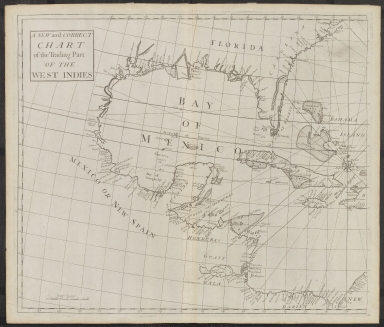
A New and Correct Chart of the Trading Part of the West Indies by Edmund Halley
Short Title
Wind and Current Chart of the North Atlantic by M. F. Maury IMAGE FILE TOO LARGE, SEE FOLDER ON P DRIVE
Short Title
Wind and Current Chart of the North Atlantic by M. F. Maury IMAGE FILE TOO LARGE, SEE FOLDER ON P DRIVE
Short Title
The Florida Land and Mortgage Company, Limited
Author
G. W. and C. B. Colton & Co.
Short Title
The Pirate and the Traders of the West Indies by William Spooner
Short Title
Preliminary Chart of Apalachicola Bay Florida
Short Title
Progress Sketch Sec. VI West Coast of Florida Tampa Bay and Vicinity -1879 United States Coast and Geodetic Survey.
Short Title
Progress Sketch Sec. VI West Coast of Florida Tampa Bay and Vicinity -1879 United States Coast and Geodetic Survey.
Short Title
Head of Tampa Bay, Fla. From Coast Chart No. 77 U. S. C. & G. S. 1887. Includes Report of Captain Black.
Short Title
Map of the Peninsula of Florida and Adjacent Islands
Author
Florida East Coast Railway
Short Title
Map of Polk County Florida Lenox E. Trickle
Short Title
Nova Tabula Exhibens Insulas Cubam et Hispaniolam vulgo S. Domingo Dictam Insulas Lucaias seu Bahamanas ac Peninsulam Floridae . . . (and) Nova Isthmi Americani qui et Panamiensis item Dariensis Tabula in qua Urbes Porto Beelo, Panama et Carthagena. The Spanish Galeon Treasure Route Past Florida and From Havana and Porto Bello To Cartagena Fine joined pair of maps, extending from Florida to Central America, published by Reiner & Josua Ottens in Amsterdam. The top map covers the Florida peninsula, Cuba, the Bahamas, Jamaica and part of Hispaniola. The map was prepared at the time of the War of Jenkin's Ear between Britain and Spain. The map details the route of the Spanish treasure ships arriving in Havana from Spain, and then heading south towards Cartagena. The lower map continues the Spanish shipping route to Cartagena, extending from Provincia Honduras to Nova Granadae and St. Martha, centered on Panama & Costa Rica. Three insets at top depict the harbors of St. Augustine, Havana, and Santo Domingo. The two maps were issued separately and as part of a large six-part map illustrating the War of Jenkin's Ear in 1740-41. While we have seen individual maps on the market and the complete 6-sheet map on the market, this is the first example we have seen which includes these two as a pair.
Short Title
Carte De La Coste De La Floride depuis la Baye de la Mobile jusqu 'aux Cayes de St. Martin
Author
Jacques-Nicolas Bellin
Short Title
Pais Cedes, Sheet 1st. containing the coast of Louisiana and Florida. By Thos. Jefferys, Geographer to His Majesty. This rare pair of charts was the forerunner of Jefferys' 1775 edition titled "The Coast of West Florida and Louisiana and "The Peninsula and Gulf of Florida....". A cursory comparison of the two editions shows a couple of important differences. The coastline west of the Mississippi delta is marked "A Flat Coast little known" and the Florida Peninsula is lacking solid coastlines with the interior a mass of interconnected waterways. The maps are traced with manuscript rhumb lines that appear to be contemporary with the issuance of the maps.
Short Title
Pais Cedes, Sheet 2d. containing the Peninsula & Gulf of Florida, with the Bahama Islands. By Thos. Jefferys, Geographer to His Majesty. This rare pair of charts was the forerunner of Jefferys' 1775 edition titled "The Coast of West Florida and Louisiana and "The Peninsula and Gulf of Florida....". A cursory comparison of the two editions shows a couple of important differences. The coastline west of the Mississippi delta is marked "A Flat Coast little known" and the Florida Peninsula is lacking solid coastlines with the interior a mass of interconnected waterways. The maps are traced with manuscript rhumb lines that appear to be contemporary with the issuance of the maps.
Short Title
Charleston Savannah & Florida Steamship Route and Connections
Short Title
Charleston Savannah & Florida Steamship Route and Connections
Short Title
image of McKenney and Hall�s hand-colored octavo edition of Billy-Bowlegs. A Seminole Chief [Rice Rutter & Co Publishers].
Short Title
Description for McKenney and Hall�s hand-colored octavo edition of Billy-Bowlegs. A Seminole Chief [Rice Rutter & Co Publishers].
Short Title
Description for McKenney and Hall�s hand-colored octavo edition of Billy-Bowlegs. A Seminole Chief [Rice Rutter & Co Publishers].
Short Title
Description for McKenney and Hall�s hand-colored octavo edition of Billy-Bowlegs. A Seminole Chief [Rice Rutter & Co Publishers].
Short Title
Description for McKenney and Hall�s hand-colored octavo edition of Billy-Bowlegs. A Seminole Chief [Rice Rutter & Co Publishers].
Short Title
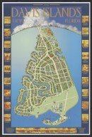
Davis Islands, Florida
Short Title
Rand, McNally & Co.'s Florida.
Author
Rand McNally and Company
Short Title
Rand, McNally & Co.'s Florida.
Author
Rand McNally and Company
Short Title
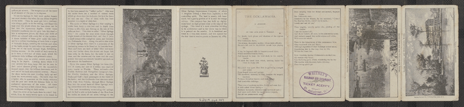
How to get to Silver Springs and the Ocklawaha River from Jacksonville
Short Title
How to get to Silver Springs and the Ocklawaha River from Jacksonville
Short Title
The Road to Florida Highway of History. Motorist May Trace Paths of Armies in Famous Campaigns. Lowell Limpus Sunday News December 29, 1935 Pages 51-54
Short Title
The Road to Florida Highway of History. Motorist May Trace Paths of Armies in Famous Campaigns. Lowell Limpus Sunday News December 29, 1935 Pages 51-54
Short Title
The Road to Florida Highway of History. Motorist May Trace Paths of Armies in Famous Campaigns. Lowell Limpus Sunday News December 29, 1935 Pages 51-54
Short Title
The Tourist News Map of Florida The Tourist News
|
![[Florida]](https://luna.tampabayhistorycenter.org/MediaManager/srvr?mediafile=/Size1/TBHC~3~3/24/M938a.jpg)


![image of McKenney and Hall�s hand-colored octavo edition of Billy-Bowlegs. A Seminole Chief [Rice Rutter & Co Publishers].](https://luna.tampabayhistorycenter.org/MediaManager/srvr?mediafile=/Size1/TBHC~3~3/111/L2019.062.005.001.jpg)
![Description for McKenney and Hall�s hand-colored octavo edition of Billy-Bowlegs. A Seminole Chief [Rice Rutter & Co Publishers].](https://luna.tampabayhistorycenter.org/MediaManager/srvr?mediafile=/Size1/TBHC~3~3/111/L2019.062.005.002-01.jpg)
![Description for McKenney and Hall�s hand-colored octavo edition of Billy-Bowlegs. A Seminole Chief [Rice Rutter & Co Publishers].](https://luna.tampabayhistorycenter.org/MediaManager/srvr?mediafile=/Size2/TBHC~3~3/111/L2019.062.005.002-02.jpg)
![Description for McKenney and Hall�s hand-colored octavo edition of Billy-Bowlegs. A Seminole Chief [Rice Rutter & Co Publishers].](https://luna.tampabayhistorycenter.org/MediaManager/srvr?mediafile=/Size2/TBHC~3~3/111/L2019.062.005.002-03.jpg)
![Description for McKenney and Hall�s hand-colored octavo edition of Billy-Bowlegs. A Seminole Chief [Rice Rutter & Co Publishers].](https://luna.tampabayhistorycenter.org/MediaManager/srvr?mediafile=/Size1/TBHC~3~3/111/L2019.062.005.002-04.jpg)