|
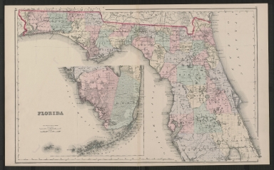
Short Title
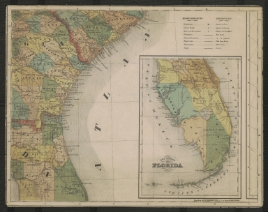
Gray's atlas map of Florida
Date Range
1873-1875
Author
O.W. Gray
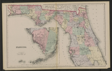
Short Title
Gray's new map of Florida
Year
1886
Author
Frank A. Gray
Short Title
Gray's new map of Florida
Year
1886
Author
Frank A. Gray
Short Title
States of South Carolina, Georgia, Alalbama, and Florida
Year
1857
Author
[Prof. H. D. Rogers, A. Keith Johnston]
Short Title
Sectional map of St Andrews Bay
Year
1911
Author
St. Andrews Bay Development Co.
Short Title
Sectional map of St Andrews Bay
Year
1911
Author
St. Andrews Bay Development Co.
Short Title
Tunison's Florida ; Tunison's Bahama Islands
Year
1903
Author
H. C. Tunison
Short Title
Tunison's Florida
Date Range
1900-1904
Author
H. C. Tunison
Short Title
A new chart of the Bahama Islands and the Windward Passage
Date Range
1716-1767
Author
Saml. Thornton
Short Title
Il paese de selvaggi Outauacesi, e Kilistinesi intorno al Lago Superiore
Date Range
1778-1788
Author
Antonio Zatta
Short Title
Carte de la Florida occidentale et Louisiane ; la peninsule et golfe de la Floride ou canal de Bahama avec les isles de Bahama.
Year
1777
Author
Thomas Jefferys
Short Title
Carte des côtes du Golfe du Mexique.
Year
1800
Author
Depot General de la Marine
Short Title
Map of Florida
Date Range
1881-1883
Author
Rand McNally & Co.
Short Title
General topographical map sheet XI : [peninsular Florida]
Date Range
1891?
Author
United States War Dept.
Short Title
Sinclair road map : Florida.
Year
1937
Author
Rand McNally and Company
Short Title
Sinclair road map : Florida.
Year
1937
Author
Rand McNally and Company
Short Title
Map of Florida showing the main line and branches of The International Railroad and Steamship Company of Florida.
Year
1884
Author
G. W. & C. B. Colton & Co.
Short Title
Map of the state of Florida.
Date Range
ca. 1874
Author
Taintor Bros. & Merrill
Short Title
Historical map of Florida.
Year
1931
Author
Florida State Department of Agriculture
Short Title
Geologic map of Florida.
Year
1945
Author
C. Wythe Cooke
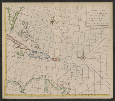
Short Title
A Chart of the Atlantick Ocean from the Oronoque River to the River May, with the Caribee and Bahama Islands
Year
1728
Short Title
East Florida, from surveys made since the last peace, adapted to Dr. Stork's history of that country.
Year
1769
Author
Thomas Jefferys
Short Title
Map of Florida.
Date Range
1910?
Author
George F. Cram
Short Title
Highway map & guide of Florida
Year
1933
Author
Mid-West Map Company
Short Title
Highway map & guide of Florida
Year
1933
Author
Mid-West Map Company
Short Title
New sectional map of eastern and southern Florida.
Date Range
1888?
Author
Matthews, Northrup & Co.
Short Title
The Rand-McNally new commercial atlas map of Florida.
Year
1913
Author
Rand McNally and Company
Short Title
The Rand-McNally new commercial atlas map of Florida.
Year
1913
Author
Rand McNally and Company
Short Title
Sunshine trails of Florida
Date Range
ca. 1924-1925
Author
Guy McHenry
Short Title
Sunshine trails of Florida
Date Range
ca. 1924-1925
Author
Guy McHenry
Short Title
Historical Map of Florida
Year
1924
Author
American Automobile Association
|


![General topographical map sheet XI : [peninsular Florida]](https://luna.tampabayhistorycenter.org/MediaManager/srvr?mediafile=/Size2/TBHC~3~3/24/M129.jpg)