Who What Where WhenWHEREShow More |
Short Title
Map of the Town Site of Clermont Sumter County, Florida
Year
1884
Author
A. F. Wrotnowski
Short Title
Map of St. Andrew's Bay Washington Co. Fla.
Author
Mc Cord Cin.
Short Title
Official Safety and Communications Map Florida International 12-Hour Grand Prix of Endurance
Date Range
ca. 1958
Short Title
Map of Highlands County. Florida
Year
1926
Author
Karl Squires
Short Title
Map Showing Property of Lake Highlands Company. Township 22- Range 26 Lake County Florida
Year
1915
Author
A. P. Gibson
Short Title
Map Showing Property of Lake Highlands Company. Township 22- Range 26 Lake County Florida
Year
1915
Author
A. P. Gibson
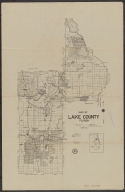
Short Title
Map of Lake County Florida
Year
1926
Author
Karl Squires
Short Title
Map of Summerall Park Heights Tavares, Lake County Florida
Year
1926
Author
G. R. Horne
Short Title
The Coast of West Florida and Louisiana / The Peninsula and Gulf of Florida or Channel of Bahama with the Bahama Islands
Year
1775
Author
Thos. Jefferys
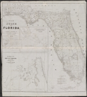
Short Title
The State of Florida
Year
1846
Author
J. Goldsborough Bruff
Short Title
A New Sectional Map of Florida
Year
1888
Author
D. H. Elliott
Short Title
A New Sectional Map of Florida
Year
1888
Author
D. H. Elliott
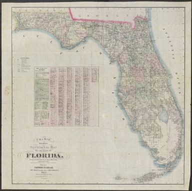
Short Title
Cram's New Indexed Sectional Map of the State of Florida, Showing Private and Government Grants, Prairie, Sawgrass Marsh, Swamp, and Hammock Lands. Compiled from official Records of the General Land Office and other Sources
Year
1884
Short Title
Preliminary Chart of Entrance to Pensacola Bay Florida
Year
1859
Author
[F. H. Gerdes, J. K. Duer]
Short Title
Map of Pensacola Florida
Short Title
Map of Pensacola Florida
Author
Municipal Advertising Board
Short Title
A Chart of the Bay and Harbour of Pensacola in the Province of West Florida
Year
1780
Short Title
Drawing No 69 Proposed Berths for Submarines & Tender Plan of U.S. Navy Yard, Pensacola, Fla.
Year
1910
Author
Warfield?
Short Title
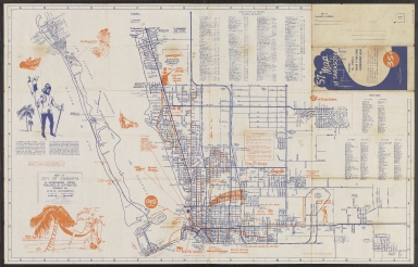
57 Map of Sarasota including all streets, major attractions, surrounding areas
Year
1956
Author
D. O. Nicholls
Short Title
57 Map of Sarasota including all streets, major attractions, surrounding areas
Year
1956
Author
D. O. Nicholls
Short Title
Map of the Highland Farms of Pasco County Florida - Property of the Tampa Bay Land Co
Year
1912
Author
Mr. Knight
Short Title
Preliminary Chart of Western Part of St. George's Sound Florida Survey of the Coast of the United States A. D. Bache
Year
1860
Author
Survey of the Coast of the United States
Short Title
Jacksonville Sectional Aeronautical Chart (P-8)
Year
1943
Author
US Coast & Geodetic Survey (base map)
Short Title
Birds Eye View of Jacksonville Florida. Inset "looking south from post office".
Short Title
Birds Eye View of Jacksonville, Florida
Year
1890
Short Title
Map of Levy County Florida
Year
1925
Author
Karl Squires
Short Title
Map of Levy County Florida
Year
1925
Author
Karl Squires
Short Title
City of Sanibel & Captiva
Date Range
ca. 1980
Author
Clear-View Maps of Florida
Short Title
City of Sanibel & Captiva
Date Range
ca. 1980
Author
Clear-View Maps of Florida
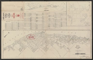
Short Title
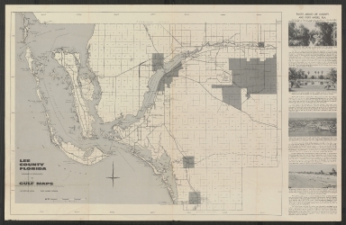
Map of City of Fort Myers Floria
Date Range
ca. 1957
Author
Gulf Maps
Short Title
Map of City of Fort Myers Floria
Date Range
ca. 1957
Author
Gulf Maps
Short Title
Port et Barre D'Amelia de la Floride Orientale
Year
1778
Date Range
1775-1778
Author
Georges Louis Le Rouge
Short Title
Map of the City of Belle Glade, Florida
Year
1965
Author
Department of Public Works of City of Belle Glade
Short Title
Map of the City of Belle Glade, Florida
Year
1965
Author
Department of Public Works of City of Belle Glade
Short Title
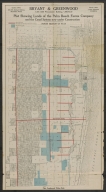
Plat Showing Lands of the Palm Beach Farms Company and the Canal System now under Construction North Section of Plat
Date Range
ca. 1909
Author
Bryant & Greenwood
|


![[Pensacola] Port de Panzacola](https://luna.tampabayhistorycenter.org/MediaManager/srvr?mediafile=/Size2/TBHC~3~3/108/2018.134.001.jpg)