Who What Where WhenWHEREShow MoreWHO
WHEN
|
Short Title
[Florida]
Year
1884
Author
Rand McNally and Company
Short Title
Points of Interest In and Around Tampa Hillsborough County Florida This is a c. 1947 Tampa Chamber of Commerce city map or plan of Tampa, Florida. The map depicts the region from Tampa Bay to the Temple Terrace Golf Club and the Florida Christian College and from Fowler Street and the Tampa Golf and Country Club to MacDill Air Force Base. Meant to be a tourist map, pictorial vignettes populate the map and highlight area attractions and activities. Numerous golf courses are marked by men and women out on the links, as are farmer's markets, baseball stadiums, tennis courts, and beaches. Florida's celebrated orange groves also make an appearance. Other sites, that most likely are not on the average tourist's itinerary, are also illustrated, including cigar factories, a cement plant, the police pistol range, and dairy cattle. Only major streets and avenues are depicted, making this map less about getting around Tampa and more about what there is to see and do. An inset map of downtown Tampa is situated in the lower left corner details this part of the city and features vignettes of Union Station, the bus terminal, city hall, the Greater Tampa Chamber of Commerce, the University of Tampa and the American Hellenic League. A definitive publication history of this map is difficult to determine as no publication information is printed on the map itself. We believe that this map was published by the Greater Tampa Chamber of Commerce c. 1947 because of the presence of MacDill Air Force Base. Although this installation was founded well before 1947, it would not have been known as an Air Force base until the U.S. Air Force was founded in 1947. We have been unable to locate any known examples of this map either on the private market or in institutional collections.
Year
1947
Short Title
Art print of 2019 painted Map of Davis Islands by Tampanian Maggie Sage Shaffer of Sagebrushed printed in 2019. 150# Cotton Cover Paper
Year
2019
Author
Maggie Sage Shaffer
Short Title
Art print of 2017 painted Map of Lake Carroll in Carrollwood by Tampanian Maggie Sage Shaffer of Sagebrushed printed in 2019. 150# Cotton Cover Paper
Year
2019
Author
Maggie Sage Shaffer
Short Title
Florida's State Parks Invite You: Visit Florida State Parks and Historic Memorials. This is a c. 1970 pictorial tourist map of Florida. Ringed by photographs of Florida attractions and activities, the map depicts the state from Alabama to the Atlantic Ocean and from Georgia and Alabama to Key West. Pictorial vignettes highlight state parks and historic memorials throughout the state, including the Florida Caverns, Manatee Springs, Turtle Mound, and Collier Seminole. A key to the left of Key West notes that four different symbols are used when marking sites around the state: circles mark parks that are in operation, squares mark partially developed parks, and triangles note undeveloped parks. Diamonds denote historic landmarks. This map was published by the Florida Board of Parks and Historic Memorials c. 1970.
Year
1970
Author
Florida Board of Parks and Historic Memorials
Short Title
Plano y calado hasta el junto que esta situado/el fuerte de Sn Marcos a Apalache en la Florida/Oriental y Rios inmediatos
Date Range
c. 1760
Short Title
Chart 10. Sketch Map of Camp "Cuba Libre" in and near Jacksonville, Fla. Occupied by 7th Army Corps. June-Nov. 1898.
Year
1898
Short Title
Gandy Bridge
Year
1947
Author
Army Map Service
Short Title
Map of Fort Myers, Florida
Year
1947
Author
Dolph, Frank B.
Short Title
Map of Fort Myers, Florida
Year
1947
Author
Dolph, Frank B.
Short Title
Map of Eastern United States and Florida's Holiday Highways
Year
1953
Author
East Coast Highways Association
Short Title
Map of Eastern United States and Florida's Holiday Highways
Year
1953
Author
East Coast Highways Association
Short Title
White fabric pillow covered with colorful embroidered pictures and words connected with Tampa and St. Petersburg. Stuffing pillow removed so only outer cover remains July 2018.
Short Title
Necktie decorated with a map of Florida, predominantly blue and white with multicolored roads and symbols.
Short Title
Souvenir handkerchief mounted on a paper or cardboard backing. It has scalloped edges and is decorated with a map of Florida surrounded by pink flowers. The words "Greetings from Florida" are in the bottom left corner.
Short Title
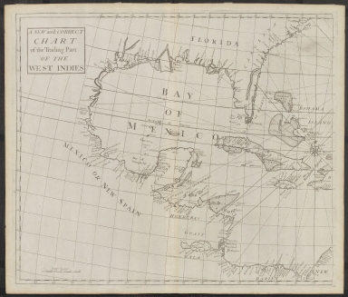
A New and Correct Chart of the Trading Part of the West Indies by Edmund Halley
Year
1728
Short Title
Wind and Current Chart of the North Atlantic by M. F. Maury IMAGE FILE TOO LARGE, SEE FOLDER ON P DRIVE
Year
1852
Short Title
Wind and Current Chart of the North Atlantic by M. F. Maury IMAGE FILE TOO LARGE, SEE FOLDER ON P DRIVE
Year
1852
Short Title
The Florida Land and Mortgage Company, Limited
Year
1884
Author
G. W. and C. B. Colton & Co.
Short Title
The Pirate and the Traders of the West Indies by William Spooner
Year
1847
Short Title
Preliminary Chart of Apalachicola Bay Florida
Year
1858
Author
A. D. Bache
Short Title
Progress Sketch Sec. VI West Coast of Florida Tampa Bay and Vicinity -1879 United States Coast and Geodetic Survey.
Year
1879
Short Title
Progress Sketch Sec. VI West Coast of Florida Tampa Bay and Vicinity -1879 United States Coast and Geodetic Survey.
Year
1879
Short Title
Head of Tampa Bay, Fla. From Coast Chart No. 77 U. S. C. & G. S. 1887. Includes Report of Captain Black.
Year
1887
Short Title
Map of the Peninsula of Florida and Adjacent Islands
Date Range
ca. 1908
Author
Florida East Coast Railway
Short Title
Map of Polk County Florida Lenox E. Trickle
Date Range
ca. 1930s
Author
Lenox E. Trickle
Short Title
Nova Tabula Exhibens Insulas Cubam et Hispaniolam vulgo S. Domingo Dictam Insulas Lucaias seu Bahamanas ac Peninsulam Floridae . . . (and) Nova Isthmi Americani qui et Panamiensis item Dariensis Tabula in qua Urbes Porto Beelo, Panama et Carthagena. The Spanish Galeon Treasure Route Past Florida and From Havana and Porto Bello To Cartagena Fine joined pair of maps, extending from Florida to Central America, published by Reiner & Josua Ottens in Amsterdam. The top map covers the Florida peninsula, Cuba, the Bahamas, Jamaica and part of Hispaniola. The map was prepared at the time of the War of Jenkin's Ear between Britain and Spain. The map details the route of the Spanish treasure ships arriving in Havana from Spain, and then heading south towards Cartagena. The lower map continues the Spanish shipping route to Cartagena, extending from Provincia Honduras to Nova Granadae and St. Martha, centered on Panama & Costa Rica. Three insets at top depict the harbors of St. Augustine, Havana, and Santo Domingo. The two maps were issued separately and as part of a large six-part map illustrating the War of Jenkin's Ear in 1740-41. While we have seen individual maps on the market and the complete 6-sheet map on the market, this is the first example we have seen which includes these two as a pair.
Year
1740
Short Title
Carte De La Coste De La Floride depuis la Baye de la Mobile jusqu 'aux Cayes de St. Martin
Year
1764
Author
Jacques-Nicolas Bellin
Short Title
Pais Cedes, Sheet 1st. containing the coast of Louisiana and Florida. By Thos. Jefferys, Geographer to His Majesty. This rare pair of charts was the forerunner of Jefferys' 1775 edition titled "The Coast of West Florida and Louisiana and "The Peninsula and Gulf of Florida....". A cursory comparison of the two editions shows a couple of important differences. The coastline west of the Mississippi delta is marked "A Flat Coast little known" and the Florida Peninsula is lacking solid coastlines with the interior a mass of interconnected waterways. The maps are traced with manuscript rhumb lines that appear to be contemporary with the issuance of the maps.
Short Title
Pais Cedes, Sheet 2d. containing the Peninsula & Gulf of Florida, with the Bahama Islands. By Thos. Jefferys, Geographer to His Majesty. This rare pair of charts was the forerunner of Jefferys' 1775 edition titled "The Coast of West Florida and Louisiana and "The Peninsula and Gulf of Florida....". A cursory comparison of the two editions shows a couple of important differences. The coastline west of the Mississippi delta is marked "A Flat Coast little known" and the Florida Peninsula is lacking solid coastlines with the interior a mass of interconnected waterways. The maps are traced with manuscript rhumb lines that appear to be contemporary with the issuance of the maps.
Short Title
Charleston Savannah & Florida Steamship Route and Connections
Date Range
1870 - 1873
Short Title
Charleston Savannah & Florida Steamship Route and Connections
Date Range
1870 - 1873
Short Title
image of McKenney and Hall�s hand-colored octavo edition of Billy-Bowlegs. A Seminole Chief [Rice Rutter & Co Publishers].
Date Range
1850s
Short Title
Description for McKenney and Hall�s hand-colored octavo edition of Billy-Bowlegs. A Seminole Chief [Rice Rutter & Co Publishers].
Date Range
1850s
Short Title
Description for McKenney and Hall�s hand-colored octavo edition of Billy-Bowlegs. A Seminole Chief [Rice Rutter & Co Publishers].
Date Range
1850s
Short Title
Description for McKenney and Hall�s hand-colored octavo edition of Billy-Bowlegs. A Seminole Chief [Rice Rutter & Co Publishers].
Date Range
1850s
Short Title
Description for McKenney and Hall�s hand-colored octavo edition of Billy-Bowlegs. A Seminole Chief [Rice Rutter & Co Publishers].
Date Range
1850s
Short Title
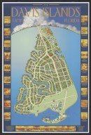
Davis Islands, Florida
Year
2006
Author
Charles Greacen
Short Title
Rand, McNally & Co.'s Florida.
Year
1888
Author
Rand McNally and Company
Short Title
Rand, McNally & Co.'s Florida.
Year
1888
Author
Rand McNally and Company
Short Title
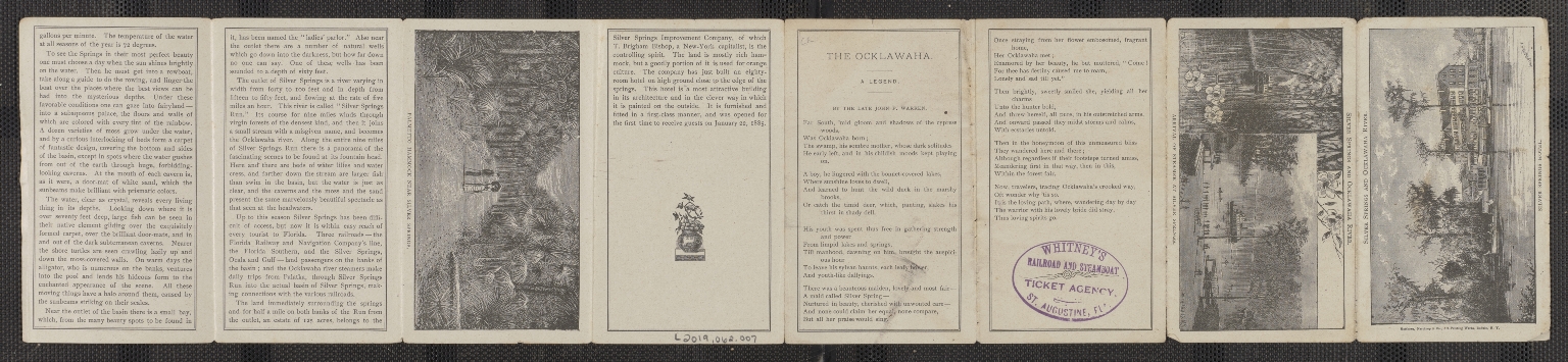
How to get to Silver Springs and the Ocklawaha River from Jacksonville
Date Range
c. 1886
Short Title
How to get to Silver Springs and the Ocklawaha River from Jacksonville
Date Range
c. 1886
Short Title
The Road to Florida Highway of History. Motorist May Trace Paths of Armies in Famous Campaigns. Lowell Limpus Sunday News December 29, 1935 Pages 51-54
Year
1935
Author
Lowell Limpus
Short Title
The Road to Florida Highway of History. Motorist May Trace Paths of Armies in Famous Campaigns. Lowell Limpus Sunday News December 29, 1935 Pages 51-54
Year
1935
Author
Lowell Limpus
Short Title
The Road to Florida Highway of History. Motorist May Trace Paths of Armies in Famous Campaigns. Lowell Limpus Sunday News December 29, 1935 Pages 51-54
Year
1935
Author
Lowell Limpus
|
![[Florida]](https://luna.tampabayhistorycenter.org/MediaManager/srvr?mediafile=/Size1/TBHC~3~3/24/M938a.jpg)


![image of McKenney and Hall�s hand-colored octavo edition of Billy-Bowlegs. A Seminole Chief [Rice Rutter & Co Publishers].](https://luna.tampabayhistorycenter.org/MediaManager/srvr?mediafile=/Size1/TBHC~3~3/111/L2019.062.005.001.jpg)
![Description for McKenney and Hall�s hand-colored octavo edition of Billy-Bowlegs. A Seminole Chief [Rice Rutter & Co Publishers].](https://luna.tampabayhistorycenter.org/MediaManager/srvr?mediafile=/Size1/TBHC~3~3/111/L2019.062.005.002-01.jpg)
![Description for McKenney and Hall�s hand-colored octavo edition of Billy-Bowlegs. A Seminole Chief [Rice Rutter & Co Publishers].](https://luna.tampabayhistorycenter.org/MediaManager/srvr?mediafile=/Size2/TBHC~3~3/111/L2019.062.005.002-02.jpg)
![Description for McKenney and Hall�s hand-colored octavo edition of Billy-Bowlegs. A Seminole Chief [Rice Rutter & Co Publishers].](https://luna.tampabayhistorycenter.org/MediaManager/srvr?mediafile=/Size2/TBHC~3~3/111/L2019.062.005.002-03.jpg)
![Description for McKenney and Hall�s hand-colored octavo edition of Billy-Bowlegs. A Seminole Chief [Rice Rutter & Co Publishers].](https://luna.tampabayhistorycenter.org/MediaManager/srvr?mediafile=/Size1/TBHC~3~3/111/L2019.062.005.002-04.jpg)