|
Short Title
Harbour of St. Augustine
Date Range
18th century
Short Title
Florida.
Date Range
ca. 1889-1892
Author
George F. Cram
Short Title
Pensacola Bay Florida & Key West Island Florida
Year
1872
Date Range
1864-1872
Author
Archibald Fullarton
Short Title
Map of Florida.
Date Range
ca. 1900-1909
Author
George F. Cram
Short Title
Map of Florida.
Date Range
ca. 1900-1909
Author
George F. Cram
Short Title
Map of Florida.
Date Range
1902?
Author
George F. Cram
Short Title
Cram's rail road & township map of Florida
Year
1881
Author
George F. Cram
Short Title
Railroad and county map of Florida
Date Range
1889?
Author
George F. Cram
Short Title
Railroad and county map of Florida
Date Range
between 1887 and 1900?
Author
George F. Cram
Short Title
Railroad and county map of Florida
Date Range
between 1887 and 1900?
Author
George F. Cram
Short Title
Map of Lake View Highlands, in sect's 4.5.8 and 9, twp. 2.5, r. 21, east, Pasadena, Pasro County, Florida.
Year
1889
Author
J. H. Neff
Short Title
Railroad and county map of Florida
Date Range
between 1888 and 1900
Author
George F. Cram
Short Title
Railroad and county map of Florida
Date Range
between 1888 and 1900
Author
George F. Cram
Short Title
Granville's Railroad and Township Map of Florida
Year
1886
Author
Charles Granville
Short Title
Florida.
Year
1911
Author
Rand, McNally and Company
Short Title
Florida.
Year
1895
Author
Rand McNally and Company
Short Title
Plan de la Baye de Pensacola dans la Floride.
Year
1764
Author
Jacques Nicolas Bellin
Short Title
The Rand McNally new commercial atlas map of Florida.
Date Range
1917?
Author
Rand McNally and Company
Short Title
The Rand McNally new commercial atlas map of Florida.
Date Range
1917?
Author
Rand McNally and Company
Short Title
Florida.
Year
1906
Author
Rand McNally and Company
Short Title
[Deposition of work "A new chart of East Florida and the Bahama Banks" by Edmund M. Blunt in U.S.District Court.]
Year
1818
Author
Edmund Blunt
Short Title
[Deposition of work "A new chart of East Florida and the Bahama Banks" by Edmund M. Blunt in U.S.District Court.]
Year
1818
Author
Edmund Blunt
Short Title
[Topographic maps of lands in Indian River County area, Florida]. Plate 3.
Date Range
1800s
Short Title
[Topographic maps of lands in Indian River County area, Florida]. Plate 4
Date Range
1800s
Short Title
[Topographic maps of lands in Indian River County area, Florida]. Plate 5
Date Range
1800s
Short Title
[Topographic maps of lands in Indian River County area, Florida]. Plate 6.
Date Range
1800s
Author
George J.F. Clarke
Short Title
[Topographic maps of lands in Indian River County area, Florida]. Plate 7.
Date Range
1800s
Short Title
Florida.
Year
1895
Author
Rand McNally and Company
Short Title
Florida.
Year
1895
Author
Rand McNally and Company
Short Title
State of Florida Township No. One North, Range No. 2 East ; Township No. 1 North, Range No. 3 East.
Date Range
1800s
Short Title
A Map of the seat of war in Florida
Year
1836
Short Title
A map of the seat of war in Florida
Year
1836
Short Title
Copy of a map of the seat of war in Florida forwarded to the War Department by Major Genl. W. Scott U.S.A.
Year
1836
Author
Lieut. J.E. Johnston
Short Title
Copy of a map of the seat of war in Florida forwarded to the War Department by Major Genl. W. Scott U.S.A.
Year
1836
Author
Lieut. J.E. Johnston
Short Title
Map of Florida showing the distribution of the pine forests, with special reference to the lumber industry.
Year
1881
Author
Charles Sprague Sargent
Short Title
[Map showing flow of St. Johns River north from Jacksonville to Atlantic Ocean]
Date Range
1900s
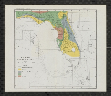
Short Title
Florida geology.
Year
1891
Author
William Healey Dall
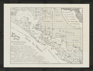
Short Title
St. Andrew's Bay.
Year
1889
Short Title
Map of DeLand, Volusia County, Florida
Year
1945
Author
Moneypenny Engineering Co.
Short Title
Florida.
Year
1879
Author
Encyclopaedia Britannica
Short Title
Florida.
Year
1879
Author
Encyclopaedia Britannica
Short Title
Florida.
Date Range
1880-1884
Author
Encyclopaedia Britannica
Short Title
Florida.
Date Range
1888 or after
Author
Encyclopaedia Britannica
|


![[Deposition of work "A new chart of East Florida and the Bahama Banks" by Edmund M. Blunt in U.S.District Court.]](https://luna.tampabayhistorycenter.org/MediaManager/srvr?mediafile=/Size1/TBHC~3~3/45/M1238.jpg)
![[Deposition of work "A new chart of East Florida and the Bahama Banks" by Edmund M. Blunt in U.S.District Court.]](https://luna.tampabayhistorycenter.org/MediaManager/srvr?mediafile=/Size2/TBHC~3~3/45/M1238+back.jpg)
![[Topographic maps of lands in Indian River County area, Florida]. Plate 3.](https://luna.tampabayhistorycenter.org/MediaManager/srvr?mediafile=/Size1/TBHC~3~3/24/M1243%28a%29.jpg)
![[Topographic maps of lands in Indian River County area, Florida]. Plate 4](https://luna.tampabayhistorycenter.org/MediaManager/srvr?mediafile=/Size1/TBHC~3~3/24/M1243%28b%29.jpg)
![[Topographic maps of lands in Indian River County area, Florida]. Plate 5](https://luna.tampabayhistorycenter.org/MediaManager/srvr?mediafile=/Size1/TBHC~3~3/24/M1243%28c%29.jpg)
![[Topographic maps of lands in Indian River County area, Florida]. Plate 6.](https://luna.tampabayhistorycenter.org/MediaManager/srvr?mediafile=/Size1/TBHC~3~3/24/M1243%28d%29.jpg)
![[Topographic maps of lands in Indian River County area, Florida]. Plate 7.](https://luna.tampabayhistorycenter.org/MediaManager/srvr?mediafile=/Size1/TBHC~3~3/24/M1243%28e%29.jpg)


![[Map showing flow of St. Johns River north from Jacksonville to Atlantic Ocean]](https://luna.tampabayhistorycenter.org/MediaManager/srvr?mediafile=/Size2/TBHC~3~3/24/M355.jpg)