|
Short Title
Chart no. 17, sponging grounds of the coast of Florida.
Year
1887
Author
Charles E. Gorham
Short Title
[Map of Patrick Air Force Base area.]
Date Range
1960s
Author
Office of Information, Air Force Eastern Test Range
Short Title
[Map of Patrick Air Force Base area.]
Date Range
1960s
Author
Office of Information, Air Force Eastern Test Range
Short Title
The sea level route, or the Ocean Highway, to Florida.
Year
1937
Author
American Automobile Association
Short Title
The sea level route, or the Ocean Highway, to Florida.
Year
1937
Author
American Automobile Association
Short Title
Map of the State of Florida.
Date Range
1829?
Author
Fenner, Sears & Co.
Short Title
Map of the State of Florida.
Year
1832
Author
Fenner, Sears & Co.
Short Title
Map of the State of Florida.
Date Range
1830s?
Author
Fenner, Sears & Co.
Short Title
Florida.
Date Range
1930s?
Author
John Bartholomew & Son
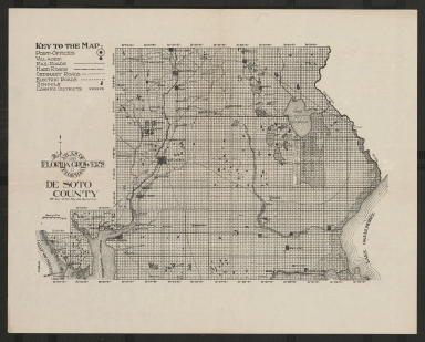
Short Title
De Soto County
Year
1914
Author
Florida Grower's Press
Short Title
N. & S. Carolina, Georgia & Florida.
Year
1828
Author
J. H. Young
Short Title
[Road map of Florida].
Year
1930
Author
American Automobile Association
Short Title
[Road map of Florida].
Year
1930
Author
American Automobile Association
Short Title
Lakes of special types. Parts of Arredondo and Williston (Fla.) sheets.
Year
1908
Author
U.S. Geological Survey
Short Title
This is Florida : summer attractions in Florida.
Date Range
1940s?
Author
Leon Cusson
Short Title
This is Florida : summer attractions in Florida.
Date Range
1940s?
Author
Leon Cusson
Short Title
Sketch map to show the approximate early or mid-Pleistocene submergence, based on the distribution of marine shell Marls and limestones.
Year
1920
Author
E. H. Sellards
Short Title
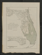
Map of Florida showing the location of three leading winter resort hotels.
Date Range
1884-1885
Short Title
LaBelle Park Lands and Citrus Center, De Soto County, Florida
Date Range
1922?
Author
Southern Land & Investment Co.
Short Title
LaBelle Park Lands and Citrus Center, De Soto County, Florida
Date Range
1922?
Author
Southern Land & Investment Co.
Short Title
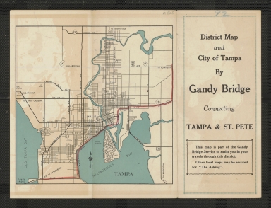
District map and city of Tampa by Gandy Bridge : connecting Tampa & St. Pete.
Year
1939
Author
Bowman Studios
Short Title
District map and city of Tampa by Gandy Bridge : connecting Tampa & St. Pete.
Year
1939
Author
Bowman Studios
Short Title
North Carolina, South Carolina, Georgia and Florida.
Date Range
after 1890
Author
James Monteith
Short Title
North Carolina, South Carolina, Georgia and Florida.
Year
1890
Author
James Monteith
Short Title
North Carolina, South Carolina, Georgia and Florida.
Year
1890
Author
James Monteith
Short Title
Township map of peninsular Florida.
Date Range
1890s
Author
Geo. Fox
Short Title
Florida and the Coast Line.
Date Range
1928?
Author
Atlantic Coast Line Railroad Co.
Short Title
The Cross Florida Barge Canal : key to Florida's integrated inland waterways system.
Year
1964
Author
Canal Authority of Florida
Short Title
The Cross Florida Barge Canal : key to Florida's integrated inland waterways system.
Year
1964
Author
Canal Authority of Florida
Short Title
Pocket guide, Greater Miami : accurate, complete.
Date Range
between 1956 and 1959
Author
Guide Publishing Co.
Short Title
Pocket guide, Greater Miami : accurate, complete.
Date Range
between 1956 and 1959
Author
Guide Publishing Co.
Short Title
Cleveland Heights : a highly restricted residential golf and country club development, Lakeland, Florida.
Date Range
ca. 1925
Author
H.A. Stahl Florida Properties Co.
Short Title
Cleveland Heights : a highly restricted residential golf and country club development, Lakeland, Florida.
Date Range
ca. 1925
Author
H.A. Stahl Florida Properties Co.
Short Title
Greater Miami In and Out guide
Year
1943
Author
Dade County Newsdealers Supply Co.
Short Title
Greater Miami In and Out guide
Year
1943
Author
Dade County Newsdealers Supply Co.
Short Title
[Property map of Pensacola, Florida.]
Year
1834
Short Title
Florida.
Date Range
1894?
Author
George F. Cram Company
Short Title
Florida.
Date Range
1894-1896?
Author
George F. Cram Company
Short Title
Florida.
Date Range
1885?
Author
George F. Cram Company
Short Title
Florida.
Date Range
1895?
Author
George F. Cram Company
Short Title
Florida.
Date Range
1887?
Author
George F. Cram Company
Short Title
Florida.
Date Range
1892?
Author
George F. Cram Company
|

![[Map of Patrick Air Force Base area.]](https://luna.tampabayhistorycenter.org/MediaManager/srvr?mediafile=/Size2/TBHC~3~3/24/M1867b.jpg)
![[Map of Patrick Air Force Base area.]](https://luna.tampabayhistorycenter.org/MediaManager/srvr?mediafile=/Size2/TBHC~3~3/24/M1867a.jpg)


![[Road map of Florida].](https://luna.tampabayhistorycenter.org/MediaManager/srvr?mediafile=/Size2/TBHC~3~3/24/M1642b.jpg)
![[Road map of Florida].](https://luna.tampabayhistorycenter.org/MediaManager/srvr?mediafile=/Size1/TBHC~3~3/24/M1642a.jpg)


![[Property map of Pensacola, Florida.]](https://luna.tampabayhistorycenter.org/MediaManager/srvr?mediafile=/Size2/TBHC~3~3/69/M1017.jpg)